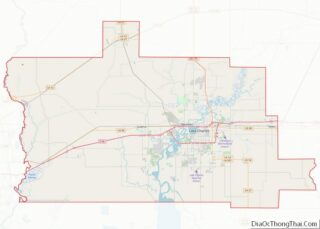
Humphreys County is a county located in the U.S. state of Mississippi. As of the 2020 census, the population was 7,785. Its county seat is Belzoni. The county is named for Benjamin G. Humphreys. Humphreys County is Mississippi’s newest county, having been formed in 1918. Humphreys County is located in the Mississippi Delta region. It ... Read more
Map of US Counties
Lincoln County is a county located in the U.S. state of Mississippi. As of the 2020 census, the population was 34,907. Its county seat is Brookhaven. The county was created by the legislature on April 7, 1870, during the Reconstruction Era. It was formed from portions of Lawrence, Pike, Franklin, Copiah, and Amite counties. It ... Read more
Prentiss County is a county located in the U.S. state of Mississippi. As of the 2020 census, the population was 25,008. Its county seat is Booneville. The county is named for Seargent Smith Prentiss, a noted speaker and US Congressman from Natchez. (Seargent was his first name, not a military title.) Prentiss County overview: Name: ... Read more
Warren County is a county located in the U.S. state of Mississippi. As of the 2020 census, the population was 44,722. Its county seat is Vicksburg. Established by legislative act of December 22, 1809, Warren County is named for American Revolutionary War officer Joseph Warren. Part of the Mississippi Delta and the historic cotton culture, ... Read more
Bollinger County is a county located in the southeastern part of the U.S. state of Missouri. As of the 2020 census, the county’s population was 10,567. The county seat is Marble Hill. The county was officially organized in 1851. Bollinger County is part of the Cape Girardeau, MO-IL Metropolitan Statistical Area. The county is the ... Read more
Clinton County is a county located in the U.S. state of Missouri and is part of the Kansas City metropolitan area. As of the 2010 U.S. Census, the county had a population of 20,743. Its county seat is Plattsburg. The county was organized January 2, 1833 and named for Governor DeWitt Clinton of New York. ... Read more
Harrison County is a county located in the northwest portion of the U.S. state of Missouri. As of the 2020 census, the population was 8,157. It’s county seat is Bethany. The county was organized February 14, 1845 and named for U.S. Representative Albert G. Harrison of Missouri. Harrison County overview: Name: Harrison County FIPS code: ... Read more
Lincoln County overview: Name: Lincoln County FIPS code: 29-113 State: Missouri Founded: December 14, 1818 Named for: Benjamin Lincoln Seat: Troy Largest city: Troy Total Area: 640 sq mi (1,700 km²) Land Area: 627 sq mi (1,620 km²) Total Population: 59,574 Population Density: 93/sq mi (36/km²) Time zone: UTC−6 (Central) Summer Time Zone (DST): UTC−5 (CDT) Website: www.lcmo.us Lincoln County location map. ... Read more
Newton County is a county located in the southwest portion of the U.S. state of Missouri. As of the 2010 census, the population was 58,114. Its county seat is Neosho. The county was organized in 1838 and is named in honor of John Newton, a hero who fought in the Revolutionary War. Newton County is ... Read more
Ray County is a county located in the northwestern portion of the U.S. state of Missouri and is part of the Kansas City metropolitan area. As of the 2020 census, the population was 23,158. Its county seat is Richmond. The county was organized November 16, 1820 and named for John Ray, a Missouri state legislator ... Read more
Sullivan County is a county located in the northern portion of the U.S. state of Missouri. As of the 2020 census, the population was 5,999. Its county seat is Milan. The county was organized February 14, 1845 and named for Major General John Sullivan of the American Revolutionary War. Sullivan County overview: Name: Sullivan County ... Read more
Cascade County overview: Name: Cascade County FIPS code: 30-013 State: Montana Founded: 1887 Named for: Great Falls of the Missouri River Seat: Great Falls Largest city: Great Falls Total Area: 2,711 sq mi (7,020 km²) Land Area: 2,698 sq mi (6,990 km²) Total Population: 84,414 Population Density: 31/sq mi (12/km²) Time zone: UTC−7 (Mountain) Summer Time Zone (DST): UTC−6 (MDT) Website: www.cascadecountymt.gov/index.php ... Read more