Dnipropetrovsk Oblast (Ukrainian: Дніпропетро́вська о́бласть, romanized: Dnipropetrovska oblast), also referred to as Dnipropetrovshchyna (Ukrainian: Дніпропетро́вщина), is an oblast (province) of southeastern Ukraine, the most important industrial region of the country. It was created on February 27, 1932. Dnipropetrovsk Oblast has a population of about 3,096,485 (2022 est.), approximately 80% of whom live centering on administrative centers: Dnipro, Kryvyi Rih, Kamianske, Nikopol and Pavlohrad. The Dnieper River runs through the oblast.
In 2019, the Constitutional Court of Ukraine approved the change of the oblast’s name to Sicheslav Oblast (Ukrainian: Січесла́вська о́бласть, romanized: Sicheslavska oblast). The change is not yet implemented.
| Unit Name | Dnipropetrovs'k Oblast |
|---|---|
| Administrative center | Dnipro |
| Major cities | Dnipro, Kryvyi Rih, Kamianske, Nikopol |
| Total area | 31.974 km² (12.345 sq mi) |
| Area Rank | Rank 2nd |
| Population (2021) | 3.142.035 |
| Time zone | UTC+2 (EET) |
| Summer (DST) | UTC+3 (EEST) |
| Postal code | 49-53xxx |
| Area code | +380-56 |
| ISO 3166 code | UA-12 |
| Website | www.adm.dp.gov.ua www.rada.gov.ua |
| Flag |  |
| Coat of arms |  |
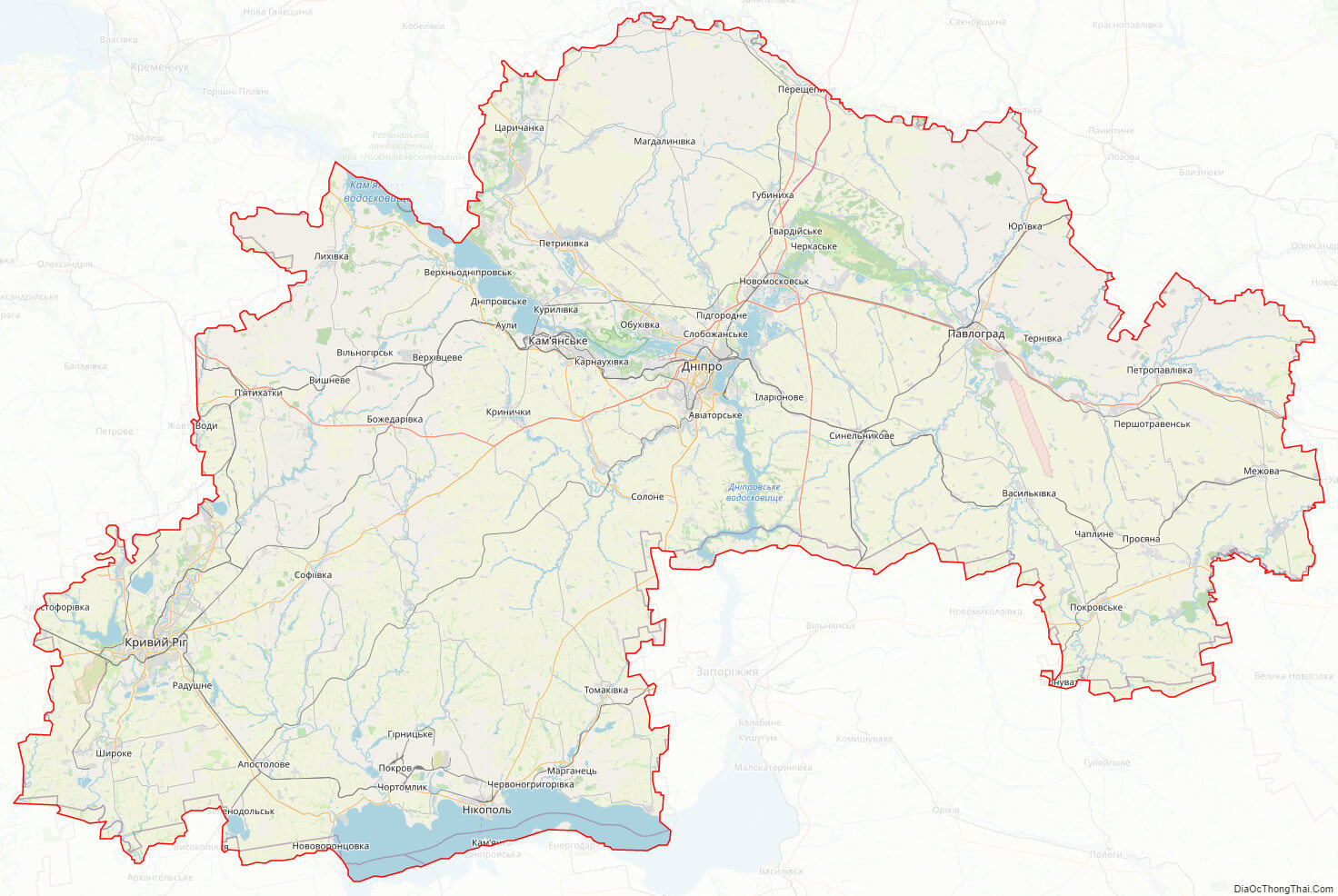
Online subdivision map of Dnipropetrovs’k oblast
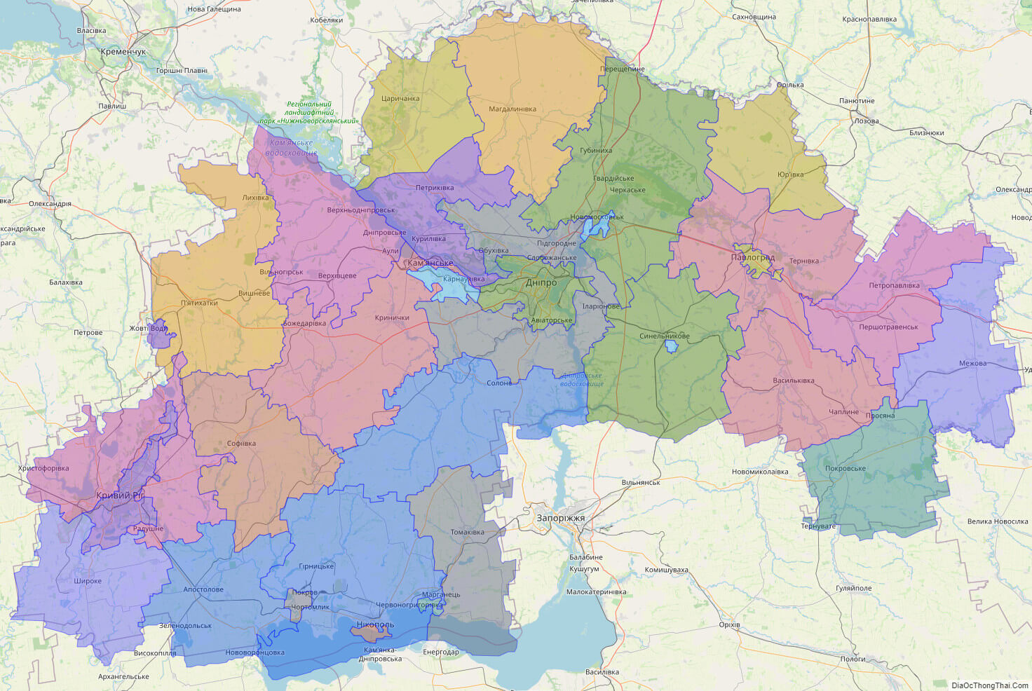
Dnipropetrovs’k oblast is one of the largest regions in Ukraine, known for its industrial centers and cultural landmarks. If you’re looking for a comprehensive map of the area’s subdivisions, you can easily find it online. This online subdivision map of Dnipropetrovs’k oblast uses OpenStreetMap and satellite imagery to provide an accurate and detailed view of the region’s borders and boundaries.
The map’s cover layer is color-coded to highlight the different sub-administrative units within the oblast. Each unit is clearly marked with a different color, making it easy to distinguish between them. With this map, you can zoom in to see individual buildings and streets or zoom out to get a broader overview of the entire region.
Whether you’re a resident of Dnipropetrovs’k oblast or just visiting, this online subdivision map is a useful tool for navigating the area. You can use it to plan your travels, find local landmarks, or simply explore the region’s unique geography. With its detailed information and user-friendly interface, this map is a must-have for anyone interested in Dnipropetrovs’k oblast.
Click on ![]() to view map in "full screen" mode.
to view map in "full screen" mode.
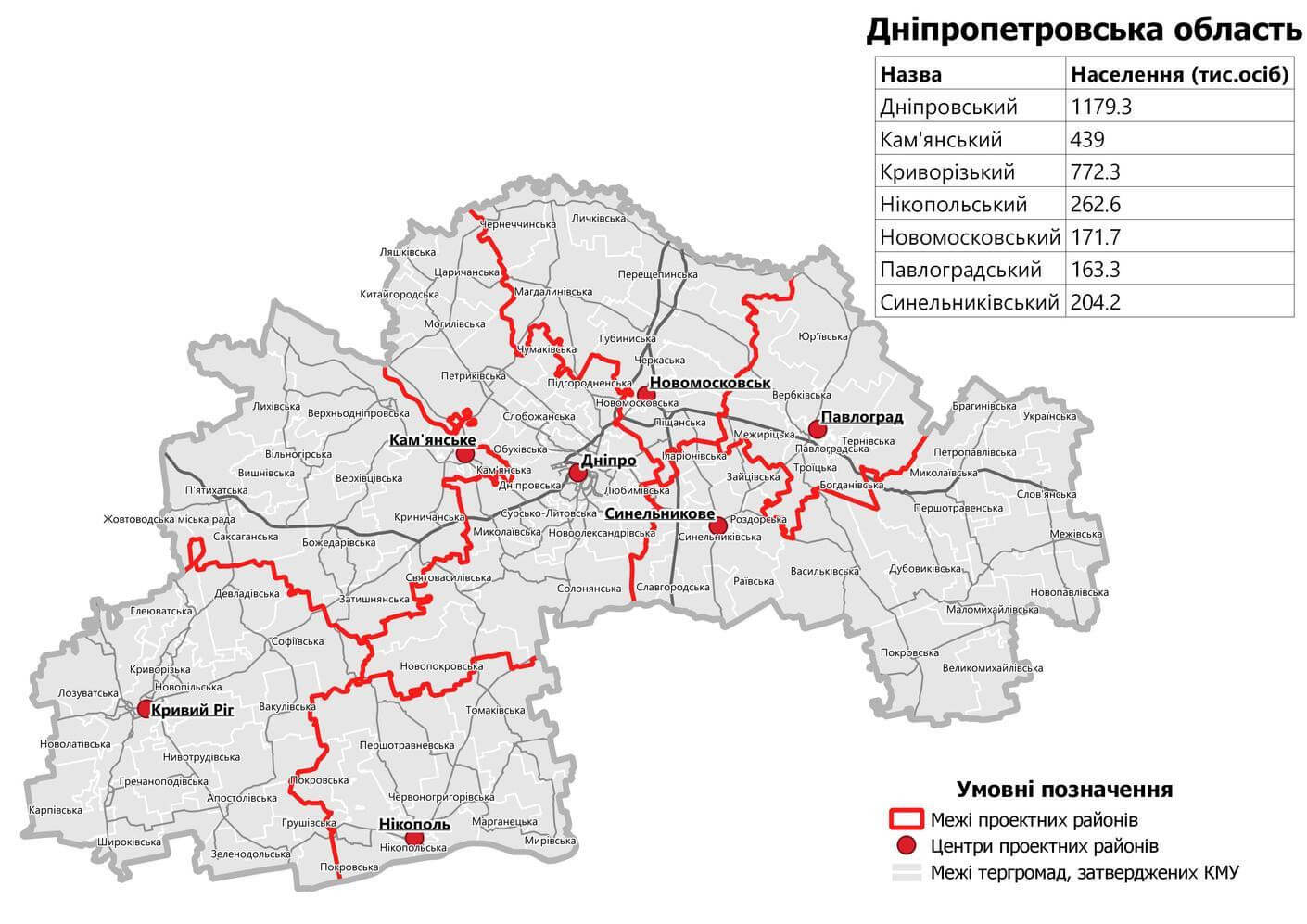
List administrative sub-division of Dnipropetrovs’k oblast
| # | Name | Type |
|---|---|---|
| 1 | Dniprodzerzhyns’ka | Mis’ka Rada |
| 2 | Dnipropetrovs’ka | Mis’ka Rada |
| 3 | Marhanets’ka | Mis’ka Rada |
| 4 | Zhovtovods’ka | Mis’ka Rada |
| 5 | KryvyiRig | Misto |
| 6 | Nikopol’s’ka | Misto |
| 7 | Novomoskovs’ka | Misto |
| 8 | Ordzhonikidzevs’ka | Misto |
| 9 | Pavlograd | Misto |
| 10 | Synel’nykivs’ka | Misto |
| 11 | Apostolivs’kyi | Raion |
| 12 | Dnipropetrovs’kyi | Raion |
| 13 | Iurïvs’kyi | Raion |
| 14 | Krynychans’kyi | Raion |
| 15 | Kryvoriz’kyi | Raion |
| 16 | Mahdalynivs’kyi | Raion |
| 17 | Mezhivs’kyi | Raion |
| 18 | Nikopol’s’kyi | Raion |
| 19 | Novomoskovs’kyi | Raion |
| 20 | Pavlohrads’kyi | Raion |
| 21 | Petropavlivs’kyi | Raion |
| 22 | Petrykivs’kyi | Raion |
| 23 | Piatykhats’kyi | Raion |
| 24 | Pokrovs’kyi | Raion |
| 25 | Shyrokivs’kyi | Raion |
| 26 | Sofi‹vs’kyi | Raion |
| 27 | Solonians’kyi | Raion |
| 28 | Synel’nykivs’kyi | Raion |
| 29 | Tomakivs’kyi | Raion |
| 30 | Tsarychans’kyi | Raion |
| 31 | Vasyl’kivs’kyi | Raion |
| 32 | Verkhn’odniprovs’kyi | Raion |
Explaination:
- Mis’ka Rada: City municipalities (governed by a mayor and a city council)
- Misto: city at least 10,000 people (not a town).
- Raion: often translated as “district”.
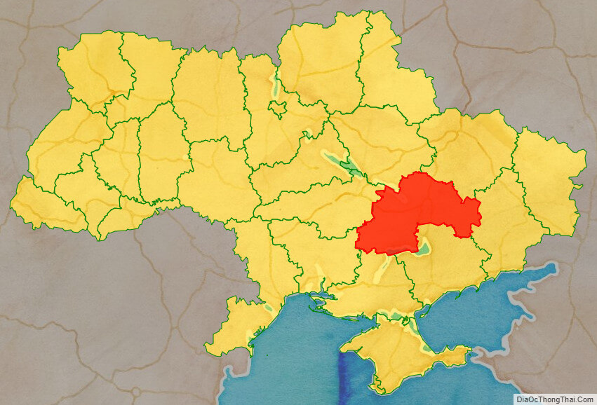
Location map of Dnipropetrovs’k oblast, Ukraine

Political map of Dnipropetrovs’k oblast

Detail map of Dnipropetrovs’k oblast
Dnipropetrovs’k oblast streeet map
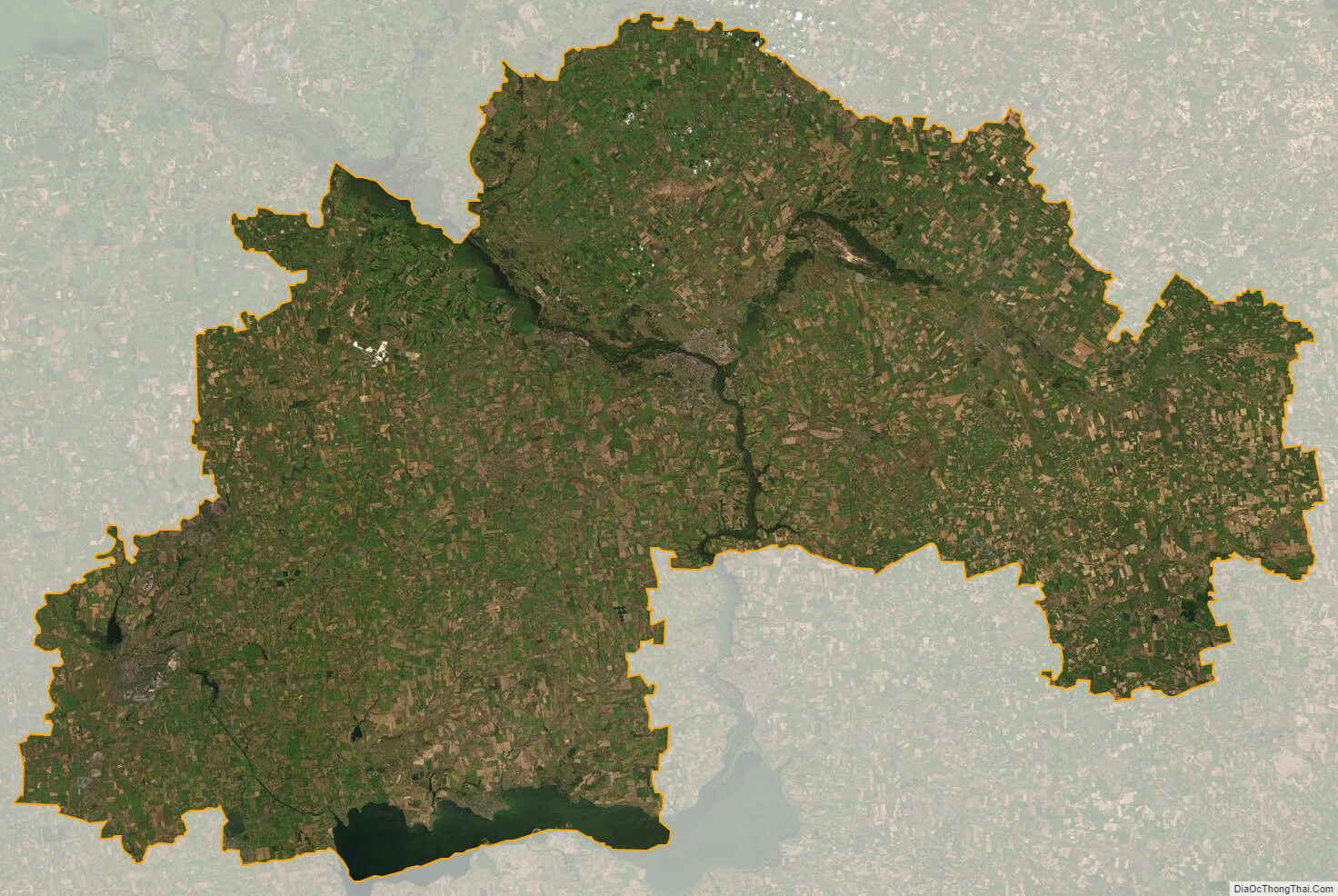
Dnipropetrovs’k oblast satellite map