Donetsk Oblast (Ukrainian: Донецька область, romanized: Donetska oblast, IPA: [doˈnɛtsʲkɐ ˈɔblɐsʲtʲ]), also referred to as Donechchyna (Донеччина), is an oblast in eastern Ukraine. It is Ukraine’s most populous province, with around 4.1 million residents. Its administrative centre is Donetsk, though due to the ongoing Russo-Ukrainian War, the regional administration was moved to Kramatorsk. Historically, the region has been an important part of the Donbas region. From its creation in 1938 until November 1961, it bore the name Stalino Oblast as Donetsk was then named “Stalino”, in honour of Joseph Stalin. As part of the de-Stalinization process, it was renamed after the Siversky Donets river, the main artery of Eastern Ukraine. Its population is estimated as 4,100,280 (2021 est.)
The oblast is known for its urban sprawl of Donetsk–Makiivka and Horlivka–Yenakiieve and it is often associated with the coal mining industry.
In 2014, parts of the oblast, including Donetsk, came under the control of Russian-backed separatists who declared the Donetsk People’s Republic, leading to a war against government forces; the de facto administrative center was subsequently moved to Mariupol and then Kramatorsk. During the 2022 Russian invasion of Ukraine, the oblast again became the site of heavy fighting, and Russia later declared the annexation of the entirety of the oblast as well as three other regions, though the annexation remains internationally unrecognized and only about half of the oblast is under Russian military occupation.
| Unit Name | Donets'k Oblast |
|---|---|
| Administrative center | Donetsk (de jure)Kramatorsk (de facto, due to war in Donbas) |
| Total area | 26.517 km² (10.238 sq mi) |
| Area Rank | Rank 11th |
| Population (2021) | 4.100.280 |
| Time zone | UTC+2 (EET) |
| Summer (DST) | UTC+3 (EEST) |
| Postal code | 83000–87999 |
| Area code | +380-62 |
| ISO 3166 code | UA-14 |
| Website | dn.gov.ua |
| Flag |  |
| Coat of arms |  |
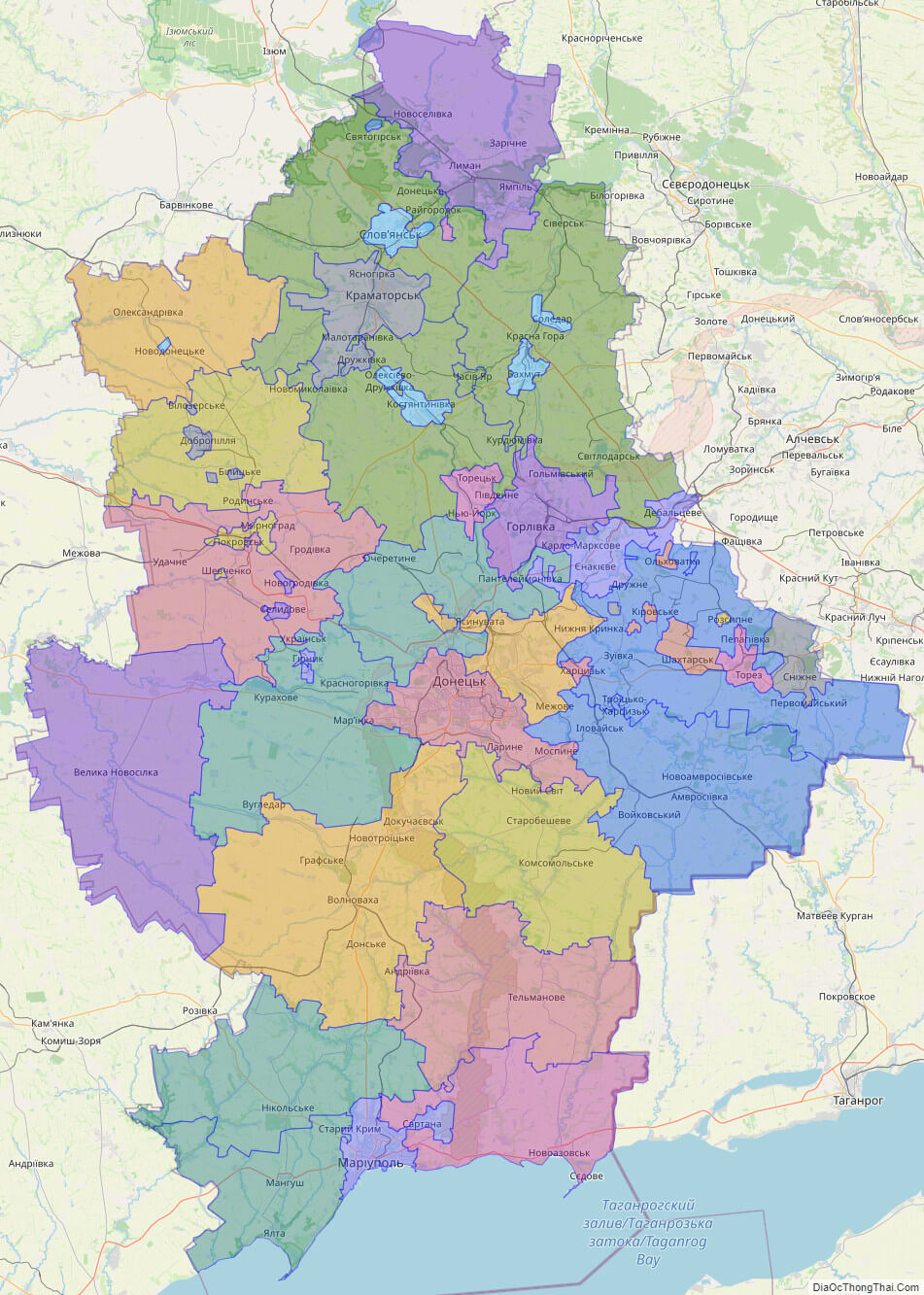
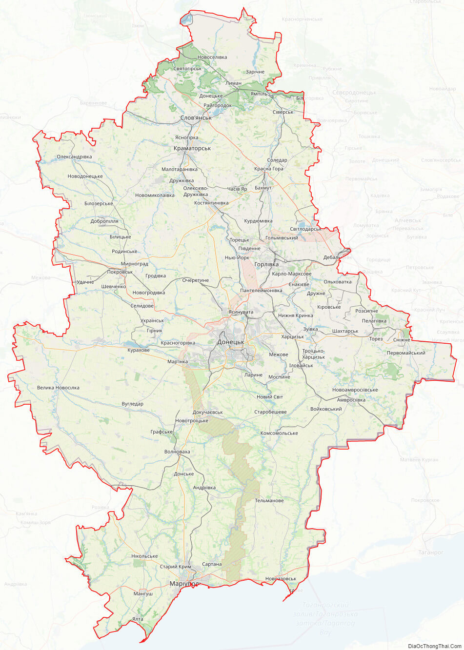
Online subdivision map of Donets’k oblast
If you’re looking to explore the Donets’k Oblast of Ukraine, an online subdivision map can be a great tool to have on hand. This type of map provides an in-depth view of the region’s sub-administrative units, including raions and municipalities.
Using an online base map, such as OpenStreetMap or satellite imagery, the subdivision map of Donets’k Oblast displays each sub-administrative unit with its own distinct color, making it easy to distinguish between them. You can zoom in and out of the map to explore the area in more detail, and easily identify important landmarks and points of interest.
Whether you’re a local resident or planning a visit to the region, an online subdivision map of Donets’k Oblast can provide valuable insights into the area’s layout and geography. With its detailed information and easy-to-use interface, it’s a great resource to have at your fingertips.
Click on ![]() to view map in "full screen" mode.
to view map in "full screen" mode.
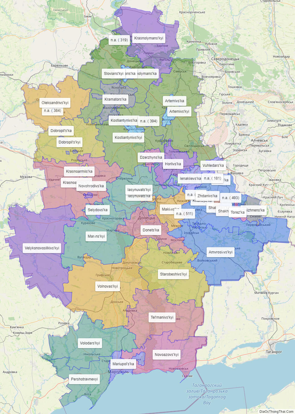
List administrative sub-division of Donets’k oblast
| # | Name | Type |
|---|---|---|
| 1 | Artemivs’ka | Mis’ka Rada |
| 2 | Dobropil’s’ka | Mis’ka Rada |
| 3 | Donets’ka | Mis’ka Rada |
| 4 | Dzerzhyns’ka | Mis’ka Rada |
| 5 | Horlivs’ka | Mis’ka Rada |
| 6 | Ienakiievs’ka | Mis’ka Rada |
| 7 | Khartsyz’ka | Mis’ka Rada |
| 8 | Kramators’ka | Mis’ka Rada |
| 9 | Krasnoarmiis’ka | Mis’ka Rada |
| 10 | Krasnolymans’ka | Mis’ka Rada |
| 11 | Maki‹vs’ka | Mis’ka Rada |
| 12 | Mariupol’s’ka | Mis’ka Rada |
| 13 | Selydovs’ka | Mis’ka Rada |
| 14 | Shakhtars’ka | Mis’ka Rada |
| 15 | Slovians’ka | Mis’ka Rada |
| 16 | Snizhnens’ka | Mis’ka Rada |
| 17 | Torez’ka | Mis’ka Rada |
| 18 | Zhdanivs’ka | Mis’ka Rada |
| 19 | Iasynuvats’ka | Misto |
| 20 | Kirovs’ka | Misto |
| 21 | Kostiantynivs’ka | Misto |
| 22 | Novohrodivs’ka | Misto |
| 23 | Vuhledars’ka | Misto |
| 24 | Amvrosi‹vs’kyi | Raion |
| 25 | Artemivs’kyi | Raion |
| 26 | Dobropil’s’kyi | Raion |
| 27 | Iasynuvats’kyi | Raion |
| 28 | Kostiantynivs’kyi | Raion |
| 29 | Krasnoarmiis’kyi | Raion |
| 30 | Krasnolymans’kyi | Raion |
| 31 | Mar‹ns’kyi | Raion |
| 32 | Novoazovs’kyi | Raion |
| 33 | Oleksandrivs’kyi | Raion |
| 34 | Pershotravnevyi | Raion |
| 35 | Shakhtars’kyi | Raion |
| 36 | Slovians’kyi | Raion |
| 37 | Starobeshivs’kyi | Raion |
| 38 | Tel’manivs’kyi | Raion |
| 39 | Velykonovosilkivs’kyi | Raion |
| 40 | Volnovas’kyi | Raion |
| 41 | Volodars’kyi | Raion |
| 42 | n.a. ( 181) | |
| 43 | n.a. ( 319) | |
| 44 | n.a. ( 384) | |
| 45 | n.a. ( 394) | |
| 46 | n.a. ( 488) | |
| 47 | n.a. ( 493) | |
| 48 | n.a. ( 511) |
Explaination:
- Mis’ka Rada: City municipalities (governed by a mayor and a city council)
- Misto: city at least 10,000 people (not a town).
- Raion: often translated as “district”.
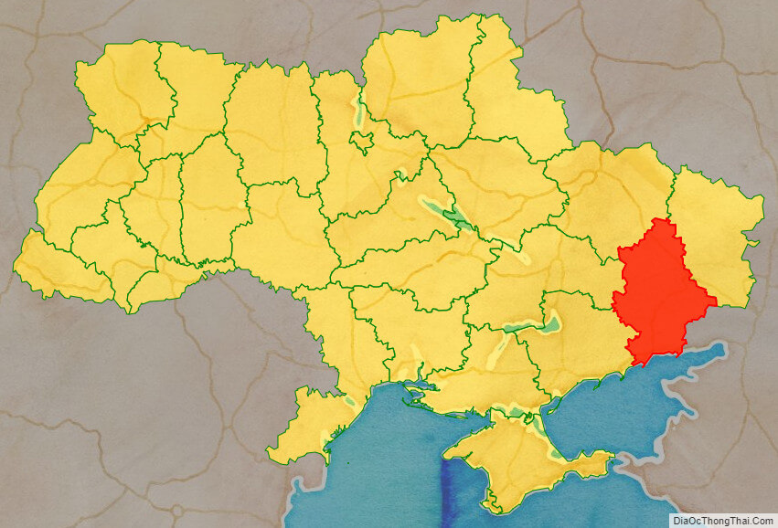
Location map of Donets’k oblast, Ukraine

Political map of Donets’k oblast
Donets’k oblast streeet map
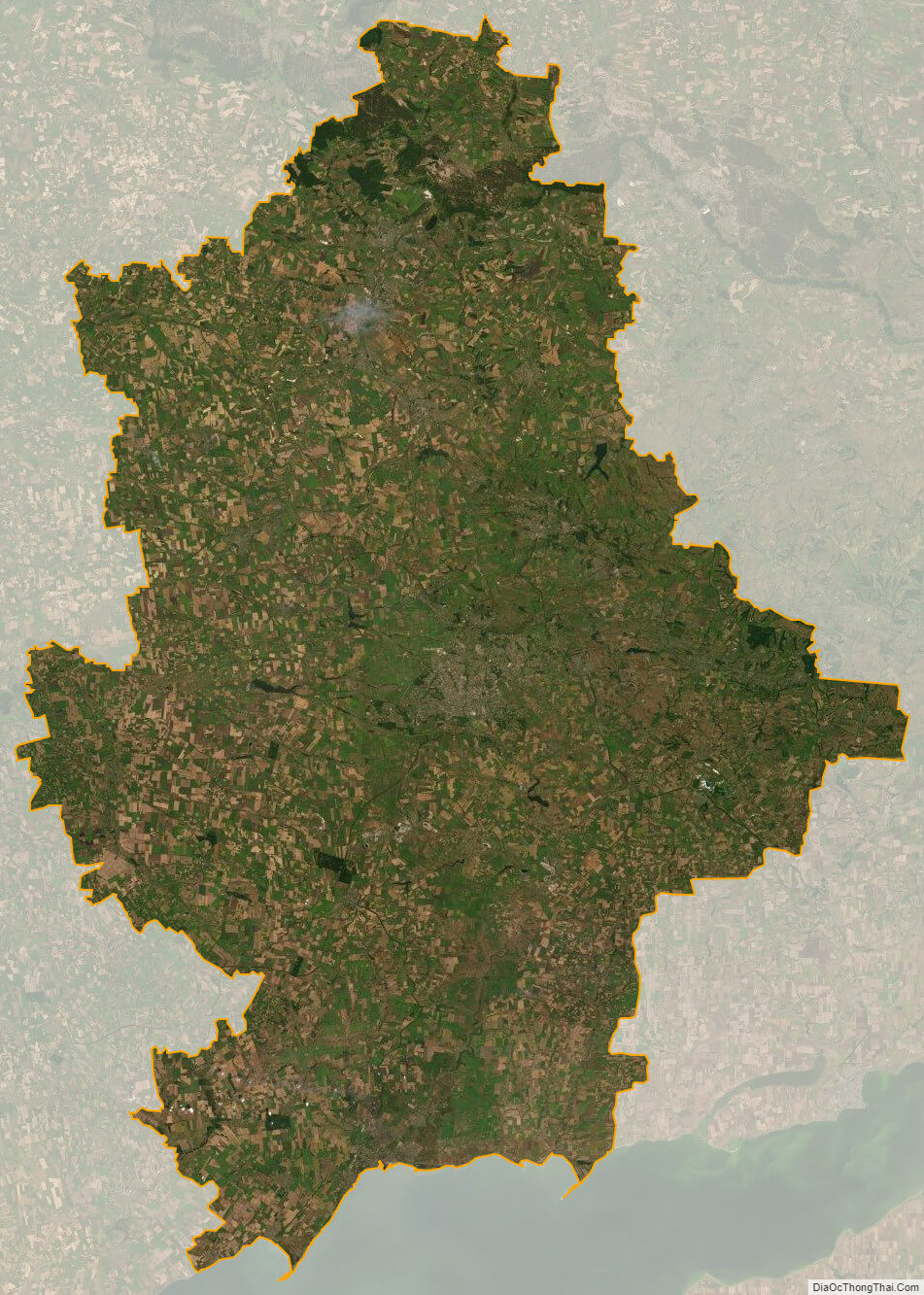
Donets’k oblast satellite map