Map of Hammondville town

Map of Hammondville town

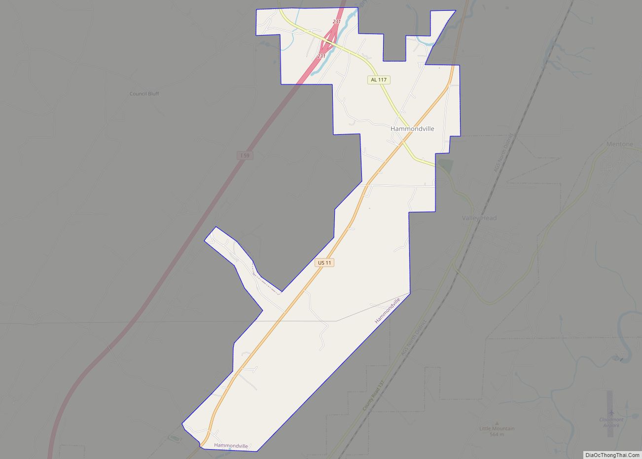
Hammondville is a town in DeKalb County, Alabama, United States. It was incorporated in 1937. As of the 2010 census, the population of the town is 488. Hammondville town overview: Name: Hammondville town LSAD Code: 43 LSAD Description: town (suffix) State: Alabama County: DeKalb County Elevation: 1,007 ft (307 m) Total Area: 4.86 sq mi (12.59 km²) Land Area: 4.85 sq mi … Read more

Map of Hamilton city

Map of Hamilton city, Alabama

Hamilton is a city in and the county seat of Marion County, Alabama, United States. It incorporated in 1896 and since 1980 has been the county’s largest city, surpassing Winfield. It was previously the largest town in 1910. At the 2020 census, the population was 7,042. Hamilton city overview: Name: Hamilton city LSAD Code: 25 … Read more

Map of Haleyville city

Map of Haleyville city

Haleyville is a city in Winston and Marion counties in the U.S. state of Alabama. It incorporated on February 28, 1889. Most of the city is located in Winston County, with a small portion of the western limits entering Marion County. Haleyville was originally named “Davis Cross Roads”, having been established at the crossroads of … Read more

Map of Hartford city

Map of Hartford city, Alabama

Hartford is a city in Geneva County, Alabama, United States. It incorporated in 1896. It is part of the Dothan, Alabama Metropolitan Statistical Area. At the 2020 census the population was 2,651, up from 2,624 in 2010. Hartford city overview: Name: Hartford city LSAD Code: 25 LSAD Description: city (suffix) State: Alabama County: Geneva County … Read more

Map of Harpersville town

Map of Harpersville town

Harpersville is a town in Shelby County, Alabama, United States. According to the 1950 U.S. Census, it formally incorporated in 1943. At the 2020 census the population was 1,614, compared to 1,637 in 2010 and 1,620 in 2000. It is located southeast of the Birmingham metro area. Harpersville town overview: Name: Harpersville town LSAD Code: … Read more

Map of Hanceville city

Map of Hanceville city

Hanceville is a city in Cullman County, Alabama, United States. At the 2020 census, the population was 3,217. Hanceville city overview: Name: Hanceville city LSAD Code: 25 LSAD Description: city (suffix) State: Alabama County: Cullman County Elevation: 548 ft (167 m) Total Area: 4.39 sq mi (11.36 km²) Land Area: 4.37 sq mi (11.32 km²) Water Area: 0.01 sq mi (0.04 km²) Total Population: 3,217 Population … Read more

Map of Hatton CDP

Map of Hatton CDP, Alabama

Hatton is a census-designated place and unincorporated community in Lawrence County, Alabama, United States. Its population was 261 as of the 2010 census. Hatton CDP overview: Name: Hatton CDP LSAD Code: 57 LSAD Description: CDP (suffix) State: Alabama County: Lawrence County Elevation: 699 ft (213 m) Total Area: 1.34 sq mi (3.47 km²) Land Area: 1.33 sq mi (3.45 km²) Water Area: 0.01 sq mi … Read more

Map of Harvest CDP

Map of Harvest CDP

Harvest is an unincorporated community and census-designated place (CDP) in the northwestern part of Madison County, Alabama, United States, and is included in the Huntsville-Decatur Combined Statistical Area. According to the 2020 U.S. Census, the population of the community is 5,893. Harvest CDP overview: Name: Harvest CDP LSAD Code: 57 LSAD Description: CDP (suffix) State: … Read more

Map of Hartselle city

Map of Hartselle city

Hartselle is the second largest city in Morgan County, Alabama, United States, 13 miles (21 km) south of Decatur. It is part of the Decatur Metropolitan Area and the Huntsville-Decatur Combined Statistical Area. As of the 2020 census, the population of the city was 15,455. Hartselle was founded in 1869 with the arrival of the South … Read more

Map of Hazel Green CDP

Map of Hazel Green CDP, Alabama

Hazel Green is an unincorporated community and census-designated place (CDP) in Madison County, Alabama, United States, and is included in the Huntsville-Decatur Combined Statistical Area. As of the 2020 census, the population of the community was 4,105, up from 3,630 at the 2010 census. Hazel Green CDP overview: Name: Hazel Green CDP LSAD Code: 57 … Read more

Map of Hayneville town

Map of Hayneville town

Hayneville is a town in Lowndes County, Alabama, United States and its county seat. At the 2010 census the population was 932, down from its record high of 1,177 in 2000. It is also part of the Montgomery Metropolitan Statistical Area. It initially incorporated in 1831, but lapsed, finally reincorporating in 1967. Before 1970, the … Read more

Map of Hayden town

Map of Hayden town, Alabama

Hayden is a town in Blount County, Alabama, United States. At the 2020 census, the population was 1,342. Hayden town overview: Name: Hayden town LSAD Code: 43 LSAD Description: town (suffix) State: Alabama County: Blount County Elevation: 564 ft (172 m) Total Area: 4.01 sq mi (10.39 km²) Land Area: 4.01 sq mi (10.39 km²) Water Area: 0.00 sq mi (0.00 km²) Total Population: 1,342 Population … Read more