Map of Heflin city

Map of Heflin city, Alabama

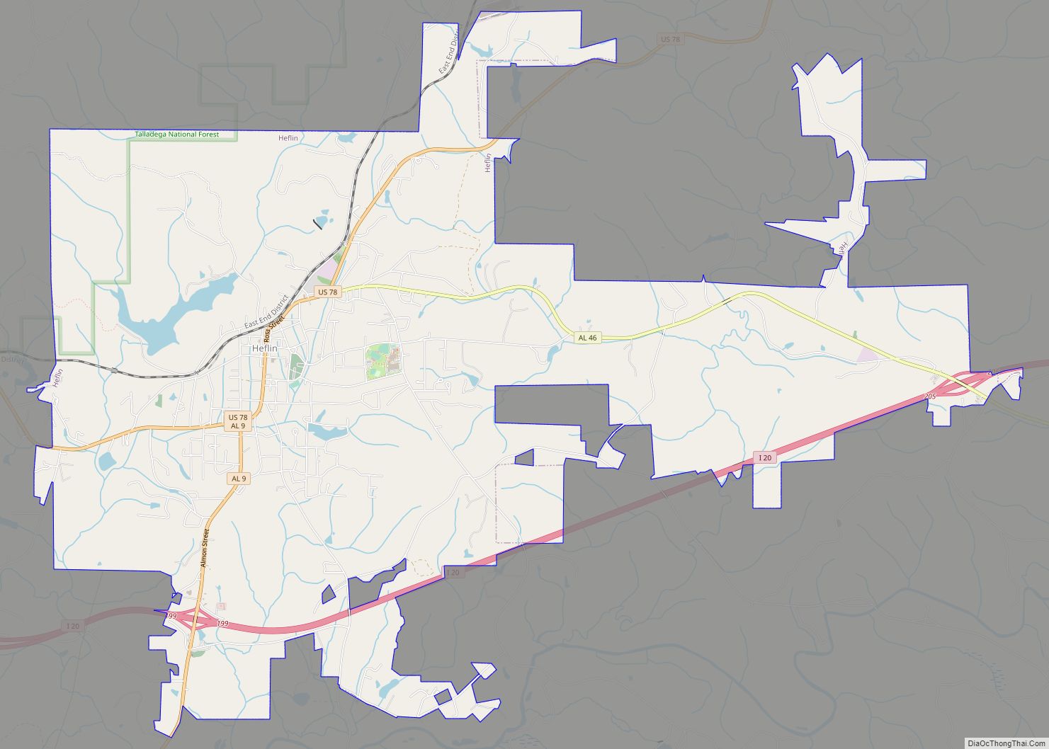
Heflin is a city and the county seat of Cleburne County, Alabama, United States. At the 2020 census, the population was 3,431. It is located approximately halfway between Birmingham and Atlanta along Interstate 20. Heflin city overview: Name: Heflin city LSAD Code: 25 LSAD Description: city (suffix) State: Alabama County: Cleburne County Incorporated: 1886 Elevation: … Read more

Map of Heath town

Map of Heath town, Alabama

Heath is a town in Covington County, Alabama, United States. At the 2020 census, the population was 236. Heath town overview: Name: Heath town LSAD Code: 43 LSAD Description: town (suffix) State: Alabama County: Covington County Elevation: 361 ft (110 m) Total Area: 0.90 sq mi (2.33 km²) Land Area: 0.89 sq mi (2.31 km²) Water Area: 0.01 sq mi (0.03 km²) Total Population: 236 Population … Read more

Map of Headland city

Map of Headland city

Headland is the largest city in Henry County, Alabama, United States. It is part of the Dothan metropolitan area. In 2020, the population was 4,973, up from 4,510 in the 2010 census. Ray Marler is the current mayor. Headland city overview: Name: Headland city LSAD Code: 25 LSAD Description: city (suffix) State: Alabama County: Henry … Read more

Map of Highland Lake town

Map of Highland Lake town

Highland Lake is a town in Blount County, Alabama, United States. At the 2020 census, the population was 412. Highland Lake town overview: Name: Highland Lake town LSAD Code: 43 LSAD Description: town (suffix) State: Alabama County: Blount County Elevation: 892 ft (272 m) Total Area: 1.99 sq mi (5.15 km²) Land Area: 1.63 sq mi (4.23 km²) Water Area: 0.36 sq mi (0.92 km²) Total … Read more

Map of Henagar city

Map of Henagar city

Henagar is a city in DeKalb County, Alabama, United States. At the 2020 census, the population was 2,292. Henagar is located on top of Sand Mountain, a southern extension of the Cumberland Plateau. Henagar city overview: Name: Henagar city LSAD Code: 25 LSAD Description: city (suffix) State: Alabama County: DeKalb County Elevation: 1,486 ft (453 m) Total … Read more

Map of Helena city

Map of Helena city, Alabama

Helena (/həˈlinə/) is a city in Jefferson and Shelby counties in the state of Alabama. Helena is considered a suburb of Birmingham and part of the Birmingham-Hoover Metropolitan Area. As of 2022 the United States Census Bureau estimates the population to be 21,560. Helena is highly regarded as a place to live and raise children; … Read more

Map of Hissop CDP

Map of Hissop CDP

Hissop is a census-designated place and unincorporated community in Coosa County, Alabama, United States. Its population was 209 as of the 2020 census. Hissop CDP overview: Name: Hissop CDP LSAD Code: 57 LSAD Description: CDP (suffix) State: Alabama County: Coosa County Elevation: 794 ft (242 m) Total Area: 10.93 sq mi (28.31 km²) Land Area: 10.93 sq mi (28.30 km²) Water Area: 0.00 sq mi … Read more

Map of Hillsboro city

Map of Hillsboro town, Alabama

Hillsboro is a town in Lawrence County, Alabama, and is included in the Decatur Metropolitan Area, as well as the Huntsville-Decatur Combined Statistical Area. It was incorporated in 1899. As of the 2010 census, the population of the town is 552, down from its record high of 608 in 2000. Along with North Courtland, it … Read more

Map of Highland Lakes CDP

Map of Highland Lakes CDP, Alabama

Highland Lakes is a census-designated place in Shelby County, Alabama, United States. Its population was 3,926 as of the 2010 census. Highland Lakes CDP overview: Name: Highland Lakes CDP LSAD Code: 57 LSAD Description: CDP (suffix) State: Alabama County: Shelby County Elevation: 810 ft (250 m) Total Area: 3.96 sq mi (10.25 km²) Land Area: 3.82 sq mi (9.88 km²) Water Area: 0.14 sq mi … Read more

Map of Hodges town

Map of Hodges town, Alabama

Hodges is a town in Franklin County, Alabama, United States. At the 2020 census, the population was 265. Hodges was laid out in 1902. It was incorporated in 1913. Hodges town overview: Name: Hodges town LSAD Code: 43 LSAD Description: town (suffix) State: Alabama County: Franklin County Elevation: 863 ft (263 m) Total Area: 4.13 sq mi (10.71 km²) Land … Read more

Map of Hobson CDP

Map of Hobson CDP, Alabama

Hobson is a census-designated place and unincorporated community in Washington County, Alabama, United States. Its population was 126 as of the 2010 census. Hobson CDP overview: Name: Hobson CDP LSAD Code: 57 LSAD Description: CDP (suffix) State: Alabama County: Washington County Elevation: 148 ft (45 m) Total Area: 2.97 sq mi (7.70 km²) Land Area: 2.94 sq mi (7.63 km²) Water Area: 0.03 sq mi … Read more

Map of Hobson City town

Map of Hobson City town

Hobson City is a town in Calhoun County, Alabama, United States. At the 2020 census, the population was 759. It is included in the Anniston-Oxford Metropolitan Statistical Area. Hobson City was Alabama’s first self-governed all-black municipality. Hobson City town overview: Name: Hobson City town LSAD Code: 43 LSAD Description: town (suffix) State: Alabama County: Calhoun … Read more