Map of Millbrook city

Map of Millbrook city, Alabama

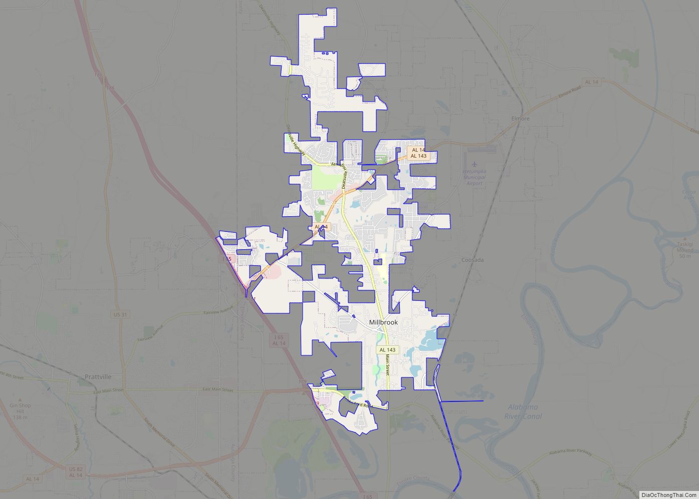
Millbrook is a city in Autauga and Elmore counties in the U.S. state of Alabama. The population was 16,564 at the 2020 census, up from 14,640 in 2010. It is part of the Montgomery Metropolitan Statistical Area. Millbrook city overview: Name: Millbrook city LSAD Code: 25 LSAD Description: city (suffix) State: Alabama County: Autauga County, … Read more

Map of Mignon CDP

Map of Mignon CDP

Mignon is a census-designated place (CDP) in Talladega County, Alabama, United States. At the 2020 census, the population was 1,186. Mignon CDP overview: Name: Mignon CDP LSAD Code: 57 LSAD Description: CDP (suffix) State: Alabama County: Talladega County Elevation: 522 ft (159 m) Total Area: 2.04 sq mi (5.27 km²) Land Area: 2.00 sq mi (5.19 km²) Water Area: 0.03 sq mi (0.09 km²) Total Population: … Read more

Map of Midway town

Map of Midway town, Alabama

Midway is a town located in eastern Bullock County, Alabama, United States. At the 2020 census, the population was 421. Midway town overview: Name: Midway town LSAD Code: 43 LSAD Description: town (suffix) State: Alabama County: Bullock County Elevation: 538 ft (164 m) Total Area: 3.31 sq mi (8.57 km²) Land Area: 3.31 sq mi (8.57 km²) Water Area: 0.00 sq mi (0.00 km²) Total Population: … Read more

Map of Millry town

Map of Millry town

Millry is a town in Washington County, Alabama, United States. According to the 1950 U.S. Census records, it incorporated in 1947. The population was 546 at the 2010 census, down from 615 in 2000. Millry town overview: Name: Millry town LSAD Code: 43 LSAD Description: town (suffix) State: Alabama County: Washington County Elevation: 105 ft (32 m) … Read more

Map of Millport town

Map of Millport town, Alabama

Millport is a town in Lamar County, Alabama, United States. It incorporated in 1887. At the 2010 census the population was 1,049, down from 1,160 in 2000. After its incorporation from 1890-1900, it was the largest town in Lamar County, losing the distinction to Sulligent. Since 1940, it has been the 3rd largest town. Millport … Read more

Map of Millerville CDP

Map of Millerville CDP, Alabama

Millerville is a census-designated place and unincorporated community in Clay County, Alabama, United States. Its population was 303 as of the 2020 census. Millerville CDP overview: Name: Millerville CDP LSAD Code: 57 LSAD Description: CDP (suffix) State: Alabama County: Clay County Elevation: 856 ft (261 m) Total Area: 6.72 sq mi (17.41 km²) Land Area: 6.70 sq mi (17.35 km²) Water Area: 0.02 sq mi … Read more

Map of Minor CDP

Map of Minor CDP

Minor is a census-designated place (CDP) in Jefferson County, Alabama, United States. It is located north of the Birmingham suburb, Pleasant Grove and has a population of 1,094 (2010 census). Minor was damaged by an F5 tornado on April 8, 1998, including damage inflicted on the non-denominational Open Door Church. Minor CDP overview: Name: Minor … Read more

Map of Montevallo city

Map of Montevallo city

Montevallo is a city in Shelby County, Alabama, United States. A college town, it is the home of the University of Montevallo, a public liberal arts university with approximately 3,000 students. As of the 2020 census, the population of the city of Montevallo is 7,229. Montevallo city overview: Name: Montevallo city LSAD Code: 25 LSAD … Read more

Map of Monroeville city

Map of Monroeville city, Alabama

Monroeville is the county seat of Monroe County, Alabama, United States. At the 2020 census its population was 5,951. Monroeville is known as the hometown of two prominent writers of the post-World War II period, Truman Capote and Harper Lee, who were childhood friends in the 1930s. Lee’s 1960 novel To Kill a Mockingbird earned … Read more

Map of Mooresville town

Map of Mooresville town, Alabama

Mooresville is a town in Limestone County, Alabama, United States, located southeast of the intersection of Interstate 565 and Interstate 65, and north of Wheeler Lake. The town is between Huntsville and Decatur, and is part of the Huntsville-Decatur Combined Statistical Area; its population as of the 2010 census is 53, down from 59 in … Read more

Map of Moores Mill CDP

Map of Moores Mill CDP

Moores Mill is an unincorporated community and census-designated place (CDP) in Madison County, Alabama, United States, and is included in the Huntsville-Decatur Combined Statistical Area. The population was 6,729 at the 2020 census, up from 5,682 at the 2010 census. Moores Mill CDP overview: Name: Moores Mill CDP LSAD Code: 57 LSAD Description: CDP (suffix) … Read more

Map of Moody city

Map of Moody city, Alabama

Moody is a city located in St. Clair County, Alabama. The city was founded in 1907, and it was named after a local businessman named Epps Moody. It is located about 22 miles east of Birmingham and has a population of approximately 12,000 people. The city covers an area of 24.5 square miles, with a … Read more