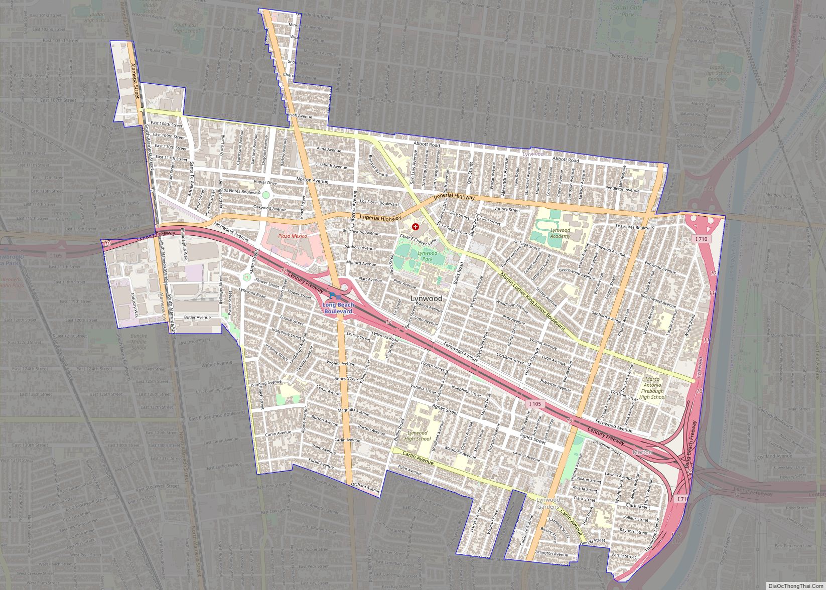
Map of Madera Acres CDP

Map of Madera Acres CDP

Madera Acres (Madera, Spanish for “wood”) is a census-designated place (CDP) in Madera County, California, United States. It is part of the Madera Metropolitan Statistical Area. The population was 9,162 at the 2020 census, virtually unchanged from 2010. Madera Acres CDP overview: Name: Madera Acres CDP LSAD Code: 57 LSAD Description: CDP (suffix) State: California … Read more

Map of Mad River CDP

Map of Mad River CDP

Mad River (formerly Kuntz) is a census-designated place (CDP) in Trinity County, California. Mad River is located in the southern part of the county. Mad River sits at an elevation of 2,484 feet (757 m). The ZIP Code is 95552. Its population is 361 as of the 2020 census, down from 420 from the 2010 census. … Read more

Map of Macdoel CDP

Map of Macdoel CDP

Macdoel is a census-designated place (CDP) in Siskiyou County, California, United States. Macdoel is located on U.S. Route 97 approximately halfway between Klamath Falls, Oregon and Weed. Its population is 86 as of the 2020 census, down from 133 from the 2010 census. Macdoel CDP overview: Name: Macdoel CDP LSAD Code: 57 LSAD Description: CDP … Read more

Map of Magalia CDP

Map of Magalia CDP

Magalia (formerly Butte Mills and Dogtown) is an unincorporated community and census-designated place (CDP) in Butte County, California, United States. The population was 11,310 at the 2010 census. Magalia CDP overview: Name: Magalia CDP LSAD Code: 57 LSAD Description: CDP (suffix) State: California County: Butte County Elevation: 2,333 ft (711 m) Total Area: 14.019 sq mi (36.309 km²) Land Area: … Read more

Map of Madison CDP, California

Map of Madison CDP, California

Madison is a census-designated place in Yolo County, California. Madison’s ZIP Code is 95653 and its area code 530. It is located 10.5 miles (17 km) west of Woodland, at an elevation of 151 feet (46 m). The 2020 United States census reported Madison’s population was 721. Madison CDP overview: Name: Madison CDP LSAD Code: 57 … Read more

Map of Madera city

Map of Madera city

Madera (Spanish for “Wood”) is a city and county seat of Madera County, California. As of the 2020 United States census, the city’s population was 66,224. Located in the San Joaquin Valley, Madera is the principal city of the Madera Metropolitan Statistical Area, which is part of the Fresno-Madera-Hanford Combined Statistical Area. The city is … Read more

Map of Mammoth Lakes town

Map of Mammoth Lakes town

Mammoth Lakes is a town in Mono County, California, and is the county’s only incorporated community. It is located immediately to the east of Mammoth Mountain, at an elevation of 7,880 feet (2,400 m). As of the 2020 United States Census, the population was 7,191, reflecting a 12.7% decrease from the 2010 Census. Mammoth Lakes town … Read more

Map of Malibu city

Map of Malibu city

Malibu (/ˈmælɪbuː/ MAL-ih-boo; Spanish: Malibú; Chumash: Humaliwo) is a beach city in the Santa Monica Mountains region of Los Angeles County, California, situated about 30 miles (48 km) west of Downtown Los Angeles. It is known for its Mediterranean climate and its 21-mile (34 km) strip of the Pacific coast, incorporated in 1991 into the city. The … Read more

Map of Malaga CDP

Map of Malaga CDP, California

Malaga (Spanish: Málaga) is a census-designated place in Fresno County, California. It is located 6 miles (9.7 km) south-southeast of downtown Fresno, at an elevation of 295 feet (90 m). As of the 2010 census, Malaga had a population of 947. Malaga CDP overview: Name: Malaga CDP LSAD Code: 57 LSAD Description: CDP (suffix) State: California … Read more

Map of Manila CDP, California

Map of Manila CDP, California

Manila is a census-designated place located adjacent to Humboldt Bay in Humboldt County, California. It is located 3.25 miles (5.2 km) north of downtown Eureka, at an elevation of 13 feet (4 m). The ZIP Code is 95521. The population was 784 at the 2010 census. Manila CDP overview: Name: Manila CDP LSAD Code: 57 LSAD … Read more

Map of Manhattan Beach city

Map of Manhattan Beach city, California

Manhattan Beach is a city in southwestern Los Angeles County, California, United States, on the Pacific coast south of El Segundo, west of Hawthorne and Redondo Beach, and north of Hermosa Beach. As of the 2010 census, the population was 35,135. Manhattan Beach is one of the three Beach Cities, along with Hermosa Beach and … Read more

Map of Manchester city

Map of Manchester CDP, California

Manchester is a census-designated place in Mendocino County, California, United States. It is located 5 miles (8 km) north of Point Arena at an elevation of 85 feet (26 m). The population was 159 at the 2020 census, down from 195 in 2010. Manchester CDP overview: Name: Manchester CDP LSAD Code: 57 LSAD Description: CDP (suffix) State: … Read more