Map of Mansfield Center CDP

Map of Mansfield Center CDP, Connecticut

Mansfield Center is a village within the town of Mansfield in Tolland County, Connecticut, United States. The village is the basis of a census-designated place (CDP) of the same name with a population of 947 at the 2010 census. The CDP includes the original settlement of Mansfield, Mansfield Center or Mansfield Village, as well as … Read more

Map of Meriden city

Map of Meriden city, Connecticut

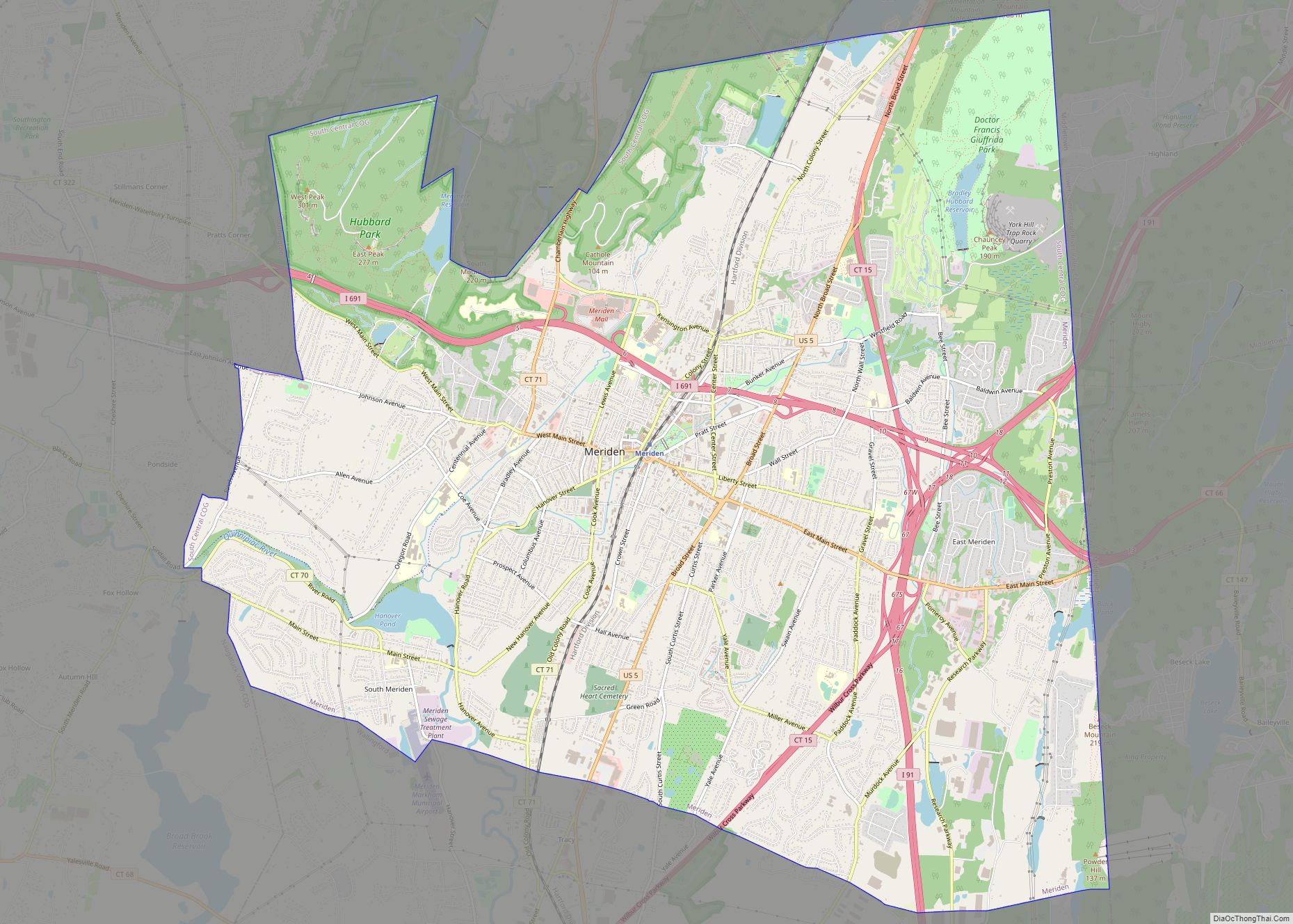
Meriden is a city in New Haven County, Connecticut, United States, located halfway between the regional cities of New Haven and Hartford. The city is part of the South Central Connecticut Planning Region. In 2020, the population of the city was 60,850. Meriden city overview: Name: Meriden city LSAD Code: 25 LSAD Description: city (suffix) … Read more

Map of Mashantucket CDP

Map of Mashantucket CDP

Mashantucket is a census-designated place (CDP) in the northeast part of the town of Ledyard, New London County, Connecticut, United States. It consists of land held by the Mashantucket Pequot Tribe. The Foxwoods Resort Casino is in the northeast part of the CDP, along Connecticut Route 2. As of the 2010 census, the CDP had … Read more

Map of Moodus CDP

Map of Moodus CDP

Moodus is a village in the town of East Haddam, Connecticut, United States. The village is the basis of a census-designated place (CDP) of the same name. The population of the CDP was 1,982 as of the census of 2020. Moodus CDP overview: Name: Moodus CDP LSAD Code: 57 LSAD Description: CDP (suffix) State: Connecticut … Read more

Map of Milford city (balance)

Map of Milford city (balance)

Milford city (balance) overview: Name: Milford city (balance) LSAD Code: 00 LSAD Description: 0 State: Connecticut County: New Haven County FIPS code: 0947515 Online Interactive Map Milford city (balance) online map. Source: Basemap layers from Google Map, Open Street Map (OSM), Arcgisonline, Wmflabs. Boundary Data from Database of Global Administrative Areas. Milford city (balance) location … Read more

Map of Middletown city, Connecticut

Map of Middletown city, Connecticut

Middletown is a city in Middlesex County, Connecticut, United States. Located along the Connecticut River, in the central part of the state, it is 16 miles (26 kilometers) south of Hartford. Middletown is the largest city in the Lower Connecticut River Valley Planning Region. In 1650, it was incorporated by English settlers as a town … Read more

Map of Naugatuck borough

Map of Naugatuck borough

Naugatuck is a consolidated borough and town in New Haven County, Connecticut, United States. The town spans both sides of the Naugatuck River just south of Waterbury and includes the communities of Union City on the east side of the river, which has its own post office, Straitsville on the southeast (along Route 63), and … Read more

Map of Mystic CDP

Map of Mystic CDP, Connecticut

Mystic is a village and census-designated place (CDP) in Groton and Stonington, Connecticut. Historically, Mystic was a significant Connecticut seaport with more than 600 ships built over 135 years starting in 1784. Mystic Seaport, one of the largest maritime museums in the United States, has preserved a number of sailing ships, such as the whaling … Read more

Map of Moosup CDP

Map of Moosup CDP

Moosup is a village and census-designated place (CDP) in the town of Plainfield, Connecticut in the United States. The population was 3,231 at the 2010 census. Moosup CDP overview: Name: Moosup CDP LSAD Code: 57 LSAD Description: CDP (suffix) State: Connecticut County: Windham County Elevation: 246 ft (75 m) Total Area: 2.3 sq mi (6 km²) Land Area: 2.2 sq mi (6 km²) … Read more

Map of New London city

Map of New London city, Connecticut

New London is a seaport city and a port of entry on the northeast coast of the United States, located at the mouth of the Thames River in New London County, Connecticut. The city is part of the Southeastern Connecticut Planning Region. New London is home to the United States Coast Guard Academy, Connecticut College, … Read more

Map of New Hartford Center CDP

Map of New Hartford Center CDP

New Hartford Center is a census-designated place (CDP) in Litchfield County, Connecticut, United States. It comprises the village of New Hartford, the adjacent Pine Meadow Historic District, and some surrounding forest land, all within the town of New Hartford. As of the 2010 census, the population of New Hartford Center was 1,385, out of 6,970 … Read more

Map of New Britain city

Map of New Britain city, Connecticut

New Britain is a city in Hartford County, Connecticut, United States. It is located approximately 9 miles (14 km) southwest of Hartford. The city is part of the Capitol Planning Region. According to 2020 Census, the population of the city is 74,135. Among the southernmost of the communities encompassed within the Hartford-Springfield Knowledge Corridor metropolitan region, … Read more