Map of San Castle CDP

Map of San Castle CDP

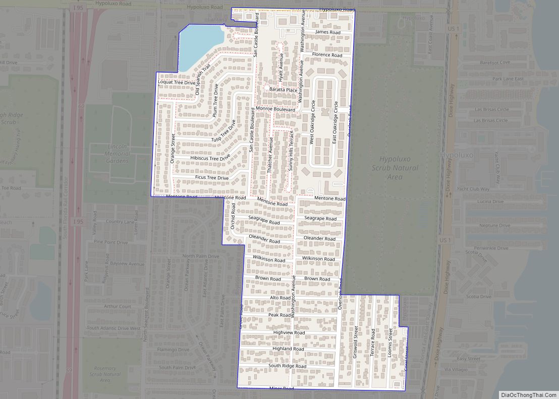
San Castle is an unincorporated community and census-designated place in Palm Beach County, Florida, United States. Its population was 3,755 as of the 2020 census. San Castle is located between Interstate 95 and the Intracoastal Waterway; it borders Lantana to the south, Hypoluxo to the west and Boynton Beach to the northeast. San Castle CDP … Read more

Map of San Carlos Park CDP

Map of San Carlos Park CDP

San Carlos Park is a census-designated place (CDP) in Lee County, Florida, United States. The population was 18,563 at the 2020 census. It is part of the Cape Coral-Fort Myers, Florida Metropolitan Statistical Area. San Carlos Park CDP overview: Name: San Carlos Park CDP LSAD Code: 57 LSAD Description: CDP (suffix) State: Florida County: Lee … Read more

Map of San Antonio city

Map of San Antonio city, Florida

San Antonio, or unofficially San Ann as the locals call it, is a city in Pasco County, Florida, United States. It is a suburban city included in the Tampa-St. Petersburg-Clearwater, Florida Metropolitan Statistical Area. It lies within Florida’s 12th congressional district. The population was 1,138 at the 2010 census. It was established as a Catholic … Read more

Map of Sarasota Springs CDP

Map of Sarasota Springs CDP

Sarasota Springs is a census-designated place (CDP) in Sarasota County, Florida, United States. The population was 14,395 at the 2010 census. It is part of the Bradenton–Sarasota–Venice Metropolitan Statistical Area. Sarasota Springs CDP overview: Name: Sarasota Springs CDP LSAD Code: 57 LSAD Description: CDP (suffix) State: Florida County: Sarasota County Elevation: 23 ft (7 m) Total Area: … Read more

Map of Sanibel city

Map of Sanibel city

Sanibel is an island and city in Lee County, Florida, United States. The population was 6,382 at the 2020 census. It is part of the Cape Coral-Fort Myers, Florida Metropolitan Statistical Area. The island, also known as Sanibel Island, constitutes the entire city. It is a barrier island—a collection of sand on the leeward side … Read more

Map of Sanford city, Florida

Map of Sanford city, Florida

Sanford is a city in the U.S. state of Florida and the county seat of Seminole County. It is located in Central Florida and its population was 61,051 as of the 2020 census. Known as the “Historic Waterfront Gateway City”, Sanford sits on the southern shore of Lake Monroe at the head of navigation on … Read more

Map of Sawgrass CDP

Map of Sawgrass CDP

Sawgrass is a census-designated place (CDP) in St. Johns County, Florida, United States. The population was 4,880 per the 2010. This population change is a -1.3% decrease since 2000. The area is located in Ponte Vedra Beach. Sawgrass is home to The Players Championship (TPC), established in 1974. The tournament offers the highest prize fund … Read more

Map of Satellite Beach city

Map of Satellite Beach city

Satellite Beach is a coastal city in Brevard County, Florida, U.S. The population was 11,346 at the 2020 United States Census, and it is located with the Atlantic Ocean to the east and the Indian River to the west. Satellite Beach is part of the Palm Bay–Melbourne–Titusville Metropolitan Statistical Area. Satellite Beach city overview: Name: … Read more

Map of Sarasota city

Map of Sarasota city

Sarasota (/ˌsærəˈsoʊtə/) is a city in Sarasota County, Florida. It is located in the southern end of the Greater Tampa Bay Area and north of Fort Myers and Punta Gorda. Its official limits include Sarasota Bay and several barrier islands between the bay and the Gulf of Mexico. Sarasota is a principal city of the … Read more

Map of Sebastian city

Map of Sebastian city, Florida

Sebastian is a city in Indian River County, Florida, United States at the confluence of the St. Sebastian River and the Indian River. It is two miles away from the Atlantic Ocean. It is the largest city in Indian River County and the biggest population center between Palm Bay and Fort Pierce. The city’s economy … Read more

Map of Sea Ranch Lakes village

Map of Sea Ranch Lakes village

Sea Ranch Lakes is a village in Broward County, Florida, United States. The population was 540 at the 2020 census. It is located on North Ocean Drive (Highway A1A) and is surrounded by Lauderdale-by-the-Sea. The majority of the village is a gated community, with the remainder being a public shopping plaza and a private beach … Read more

Map of Schall Circle CDP

Map of Schall Circle CDP

Schall Circle is a census-designated place (CDP) in Palm Beach County, Florida, United States. The population was 792 at the 2020 census. Schall Circle CDP overview: Name: Schall Circle CDP LSAD Code: 57 LSAD Description: CDP (suffix) State: Florida County: Palm Beach County Elevation: 13 ft (4 m) Total Area: 0.24 sq mi (0.62 km²) Land Area: 0.24 sq mi (0.62 km²) Water … Read more