Map of Milan city, Georgia
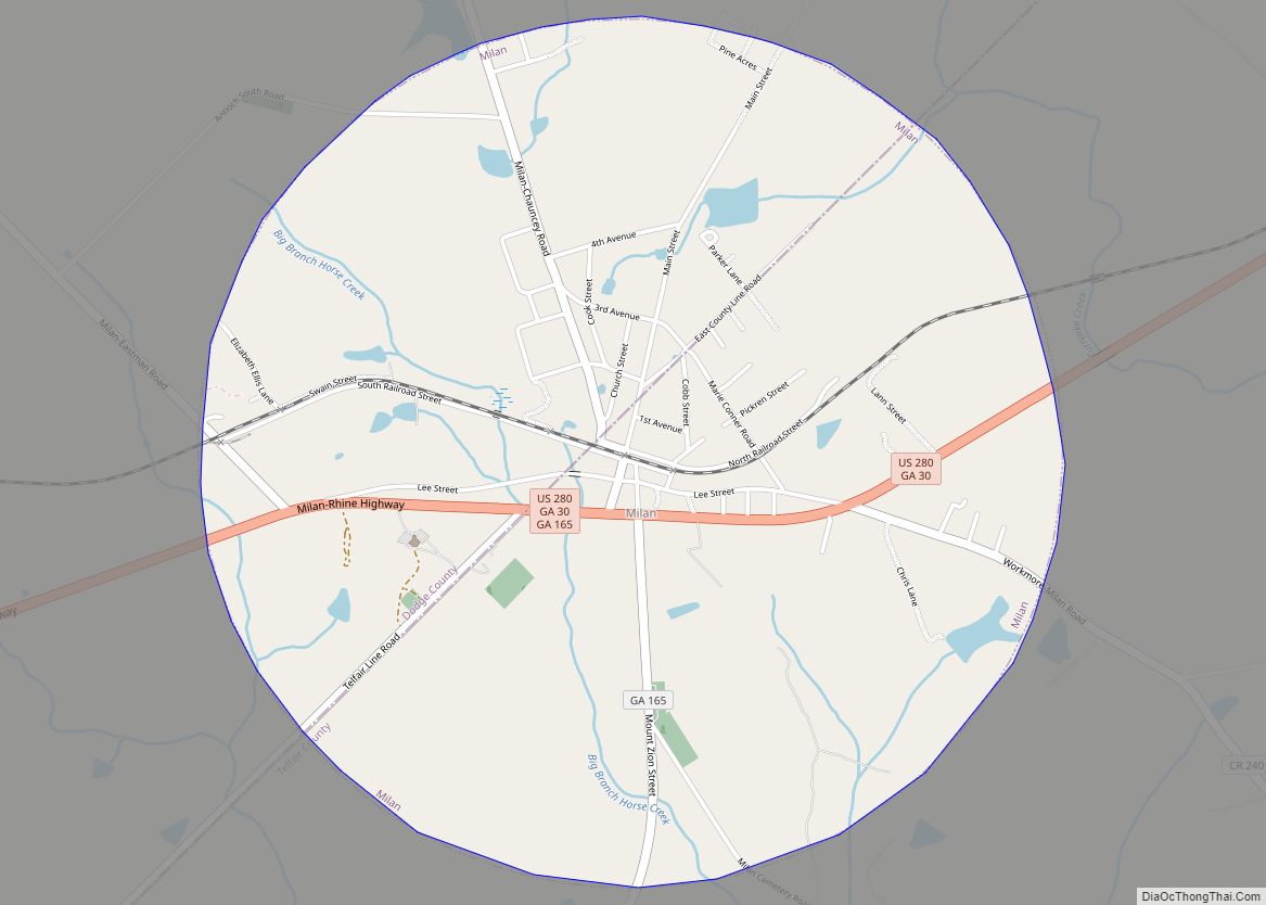
Milan (/ˈmaɪlən/ MY-lən) is a city in Dodge and Telfair counties in the U.S. state of Georgia. The population was 700 at the 2010 census, down from 1,012 in 2000. Milan city overview: Name: Milan city LSAD Code: 25 LSAD Description: city (suffix) State: Georgia County: Dodge County, Telfair County Elevation: 312 ft (95 m) Total Area: ... Read more
Map of Milan city, Georgia
Map of Mineral Bluff CDP
Mineral Bluff is a census-designated place and unincorporated community located in Fannin County in the U.S. state of Georgia. Its population was 223 as of the 2020 census. The community is situated 6 miles (10 km) northeast of the city of Blue Ridge, the county seat, 80 miles (130 km) east of Chattanooga, Tennessee, and 100 miles ... Read more
Map of Mineral Bluff CDP
Map of Milton city, Georgia
Milton is a city in Fulton County, Georgia, United States. Located about 30 miles due north of Atlanta, Milton is known for its rural and equestrian heritage. The City was incorporated on December 1, 2006, out of the unincorporated northernmost part of northern Fulton County. As of the 2010 census, Milton’s population was 32,661, with ... Read more
Map of Milton city, Georgia
Map of Milner city
Milner is a city in Lamar County, Georgia, United States. The population was 610 at the 2010 census, up from 522 at the 2000 census. Milner is part of the official Atlanta 29 County Metropolitan Statistical Area – MSA. Milner city overview: Name: Milner city LSAD Code: 25 LSAD Description: city (suffix) State: Georgia County: ... Read more
Map of Milner city
Map of Monroe city, Georgia
Monroe is a city in Walton County, Georgia, United States, serving as the county seat. It is located both one hour east of Atlanta via US 78 and GA 138 to I-20 and east of Hartsfield–Jackson International Airport and is one of the exurban cities in the Atlanta metropolitan area. The population was 14,928 at ... Read more
Map of Monroe city, Georgia
Map of Molena city
Molena is a city in Pike County, Georgia, United States. The population was 475 at the 2000 census. Molena city overview: Name: Molena city LSAD Code: 25 LSAD Description: city (suffix) State: Georgia County: Pike County Elevation: 768 ft (234 m) Total Area: 1.89 sq mi (4.89 km²) Land Area: 1.87 sq mi (4.85 km²) Water Area: 0.01 sq mi (0.04 km²) Total Population: 392 Population ... Read more
Map of Molena city
Map of Mitchell town, Georgia
Mitchell is a town in Glascock County, Georgia, United States. The population was 199 at the 2010 census. Mitchell is home to the Mitchell Depot Historical Museum. Mitchell town overview: Name: Mitchell town LSAD Code: 43 LSAD Description: town (suffix) State: Georgia County: Glascock County Elevation: 535 ft (163 m) Total Area: 1.48 sq mi (3.85 km²) Land Area: 1.48 sq mi ... Read more
Map of Mitchell town, Georgia
Map of Monticello city, Georgia
Monticello is the largest city in and the county seat of Jasper County, Georgia, United States. The city includes historic buildings such as the Jasper County Courthouse, Monticello High School and the Monticello Historic District. The population was 2,657 at the 2010 census. It is 56 miles (90 km) southeast of Atlanta. Monticello city overview: Name: ... Read more
Map of Monticello city, Georgia
Map of Montgomery CDP, Georgia
Montgomery is a census-designated place (CDP) in Chatham County, Georgia, United States. The population was 4,443 at the 2020 United States Census, down slightly from 4,523 in 2010. It is a suburb of Savannah and is part of the Savannah metropolitan area. Montgomery CDP overview: Name: Montgomery CDP LSAD Code: 57 LSAD Description: CDP (suffix) ... Read more
Map of Montgomery CDP, Georgia
Map of Montezuma city, Georgia
Montezuma is a city in Macon County, Georgia (ZIP code 31063). The population was 3,047 at the 2020 census, down from 3,460 in 2010. It is home to the armory of Bravo Company, 648th Engineers of the Georgia Army National Guard. Montezuma city overview: Name: Montezuma city LSAD Code: 25 LSAD Description: city (suffix) State: ... Read more
Map of Montezuma city, Georgia
Map of Moreland town, Georgia
Moreland is a town in Coweta County, Georgia, United States. As of the 2020 census, the town population was 382. The author Erskine Caldwell was born in Moreland in 1903. Newspaper columnist Lewis Grizzard grew up in the town. Moreland town overview: Name: Moreland town LSAD Code: 43 LSAD Description: town (suffix) State: Georgia County: ... Read more
Map of Moreland town, Georgia
Map of Moody AFB CDP
Moody Air Force Base (AFB) (IATA: VAD, ICAO: KVAD, FAA LID: VAD) is a United States Air Force installation near Valdosta, Georgia. Moody AFB CDP overview: Name: Moody AFB CDP LSAD Code: 57 LSAD Description: CDP (suffix) State: Georgia County: Lowndes County Elevation: 71 metres (233 ft) FIPS code: 1352556 Website: www.moody.af.mil/ Online Interactive Map Moody ... Read more
Map of Moody AFB CDP