Map of Middleton city

Map of Middleton city, Idaho

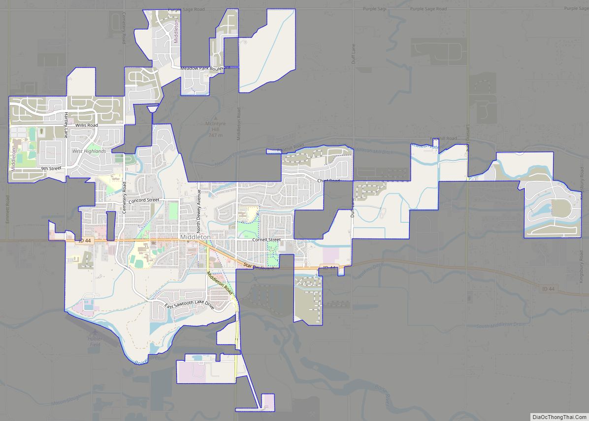
Middleton is a city in Canyon County, Idaho, United States. The population amounted to 9,091 at the 2021 census estimate, up from 5,524 at the 2010 census and 2,978 in 2000. It is part of the Boise City–Nampa, Idaho Metropolitan Statistical Area. Middleton city overview: Name: Middleton city LSAD Code: 25 LSAD Description: city (suffix) … Read more

Map of Moreland CDP, Idaho

Map of Moreland CDP, Idaho

Moreland is a census-designated place in Bingham County, Idaho, United States. Its population was 1,278 as of the 2010 census. Moreland CDP overview: Name: Moreland CDP LSAD Code: 57 LSAD Description: CDP (suffix) State: Idaho County: Bingham County Elevation: 4,462 ft (1,360 m) Total Area: 2.437 sq mi (6.31 km²) Land Area: 2.437 sq mi (6.31 km²) Water Area: 0 sq mi (0 km²) Total Population: … Read more

Map of Moore city

Map of Moore city, Idaho

Moore is a city in Butte County, Idaho, United States. The population was 162 at the 2020 census. Moore city overview: Name: Moore city LSAD Code: 25 LSAD Description: city (suffix) State: Idaho County: Butte County Elevation: 5,472 ft (1,668 m) Total Area: 0.28 sq mi (0.74 km²) Land Area: 0.28 sq mi (0.74 km²) Water Area: 0.00 sq mi (0.00 km²) Total Population: 162 Population … Read more

Map of Montpelier city

Map of Montpelier city, Idaho

Montpelier is a city in Bear Lake County, Idaho, United States. The population was 2,538 at the 2019 estimation, down from 2,597 in 2010 census. The city is the largest community in the Bear Lake Valley, a farming region north of Bear Lake in southeastern Idaho along the Utah border. It was settled in 1863 … Read more

Map of Mud Lake city

Map of Mud Lake city

Mud Lake is a city in Jefferson County, Idaho, United States. It is part of the Idaho Falls, Idaho Metropolitan Statistical Area. The population was 358 at the 2010 census. Since then the population has grown to 419 as seen in the 2020 census as well as idaho demographics Mud Lake is also home to … Read more

Map of Moyie Springs city

Map of Moyie Springs city

Moyie Springs is a city in Boundary County, Idaho, United States. The population was 718 at the 2010 census. Moyie Springs city overview: Name: Moyie Springs city LSAD Code: 25 LSAD Description: city (suffix) State: Idaho County: Boundary County Elevation: 2,215 ft (675 m) Total Area: 1.51 sq mi (3.91 km²) Land Area: 1.51 sq mi (3.91 km²) Water Area: 0.00 sq mi (0.00 km²) Total … Read more

Map of Mountain Home city, Idaho

Map of Mountain Home city, Idaho

Mountain Home is the largest city and county seat of Elmore County, Idaho, United States. The population was 15,979 in the 2020 census. Mountain Home is the principal city of the Mountain Home, Idaho Micropolitan Statistical Area, which includes Elmore County. Mountain Home was originally a post office at Rattlesnake Station, a stagecoach stop on … Read more

Map of Mountain Home AFB CDP

Map of Mountain Home AFB CDP

Mountain Home Air Force Base (IATA: MUO, ICAO: KMUO, FAA LID: MUO) is a United States Air Force (USAF) installation in the western United States. Located in southwestern Idaho in Elmore County, the base is twelve miles (20 km) southwest of Mountain Home, which is forty miles (65 km) southeast of Boise via Interstate 84. The base … Read more

Map of Moscow city

Map of Moscow city, Idaho

Moscow (/ˈmɒskoʊ/ MOS-koh) is a city in North Central Idaho, United States. Located along the state border with Washington, it had a population of 25,435 at the 2020 census. The county seat and largest city of Latah County, Moscow is the home of the University of Idaho, the state’s land-grant institution and primary research university. … Read more

Map of New Plymouth city

Map of New Plymouth city

New Plymouth is a city in Payette County, Idaho. The population was 1,538 at the 2010 census, up from 1400 in 2000. It was incorporated on February 15, 1896. It is the host of the annual Payette County Fair and rodeo. New Plymouth is part of the Ontario, OR–ID Micropolitan Statistical Area. New Plymouth city … Read more

Map of New Meadows city

Map of New Meadows city

New Meadows is a rural city in Adams County, Idaho, United States, at the southern and upper end of the Meadows Valley, on the Little Salmon River. Located in the west central part of the state, just south of the 45th parallel, the population was 496 at the 2010 census, down from 533 in 2000. … Read more

Map of Murtaugh city

Map of Murtaugh city

Murtaugh is a rural town in Twin Falls County, Idaho, United States. The population was 115 at the 2010 census, down from 139 in 2000. It is part of the Twin Falls, Idaho Micropolitan Statistical Area. Murtaugh has existed since at least the early 1950s, and is named after Mark Murtaugh, who oversaw a local … Read more