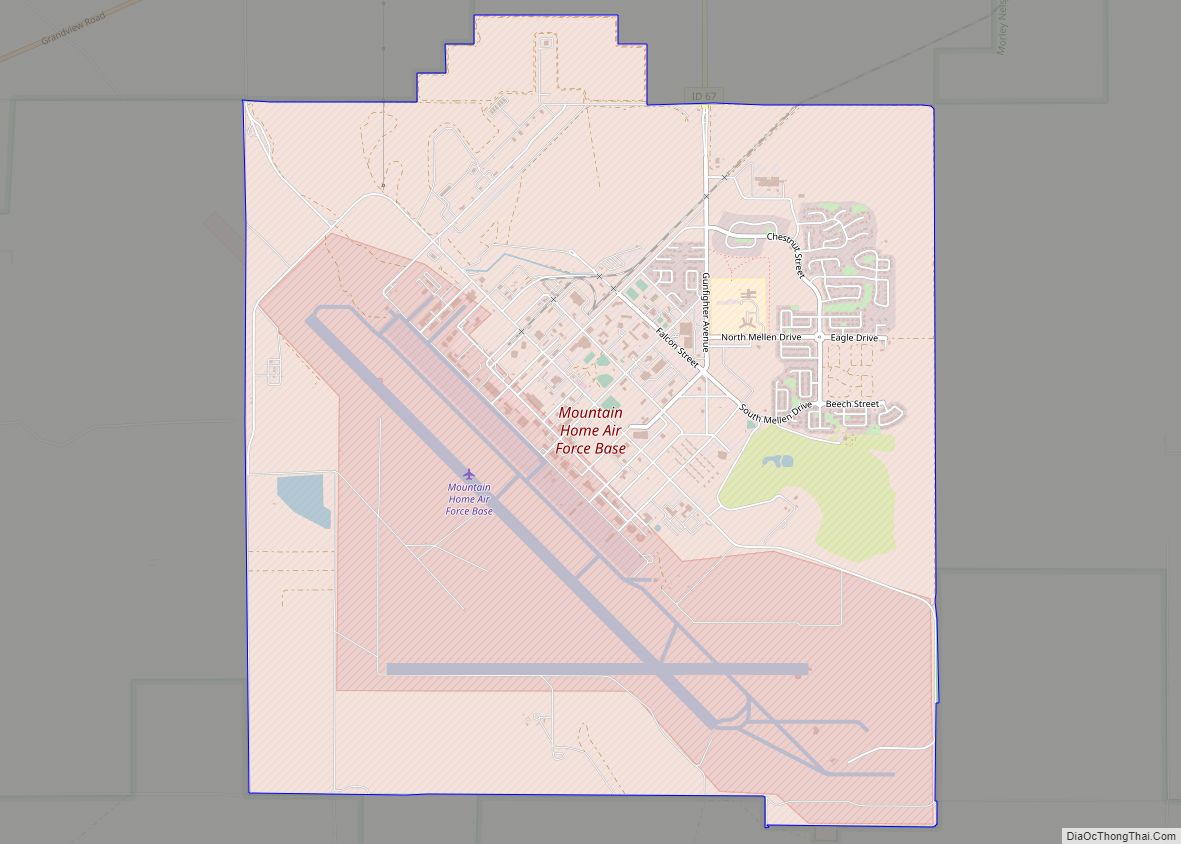
Mountain Home Air Force Base (IATA: MUO, ICAO: KMUO, FAA LID: MUO) is a United States Air Force (USAF) installation in the western United States. Located in southwestern Idaho in Elmore County, the base is twelve miles (20 km) southwest of Mountain Home, which is forty miles (65 km) southeast of Boise via Interstate 84. The base is also used by the Republic of Singapore Air Force (RSAF), which has a detachment of F-15SG combat aircraft on long term assignment to the base and a squadron composing of RSAF and USAF personnel.
The host unit at Mountain Home since 1972 has been the 366th Fighter Wing (366 FW) of Air Combat Command (ACC), nicknamed the “Gunfighters.” The base’s primary mission is to provide combat airpower and combat support capabilities to respond to and sustain worldwide contingency operations.
Constructed in the early 1940s during World War II as a training base for bombers, after the war it briefly had transports, then was a bomber and missile base. It became a fighter base 57 years ago in 1966.
Part of the base is a census-designated place (CDP); the population was 3,238 at the 2010 census.
| Name: | Mountain Home AFB CDP |
|---|---|
| LSAD Code: | 57 |
| LSAD Description: | CDP (suffix) |
| State: | Idaho |
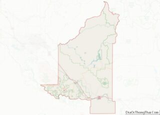
| County: | Elmore County |
| Elevation: | 913.1 metres (2,996 ft) |
| FIPS code: | 1654820 |
| Website: | www.mountainhome.af.mil |
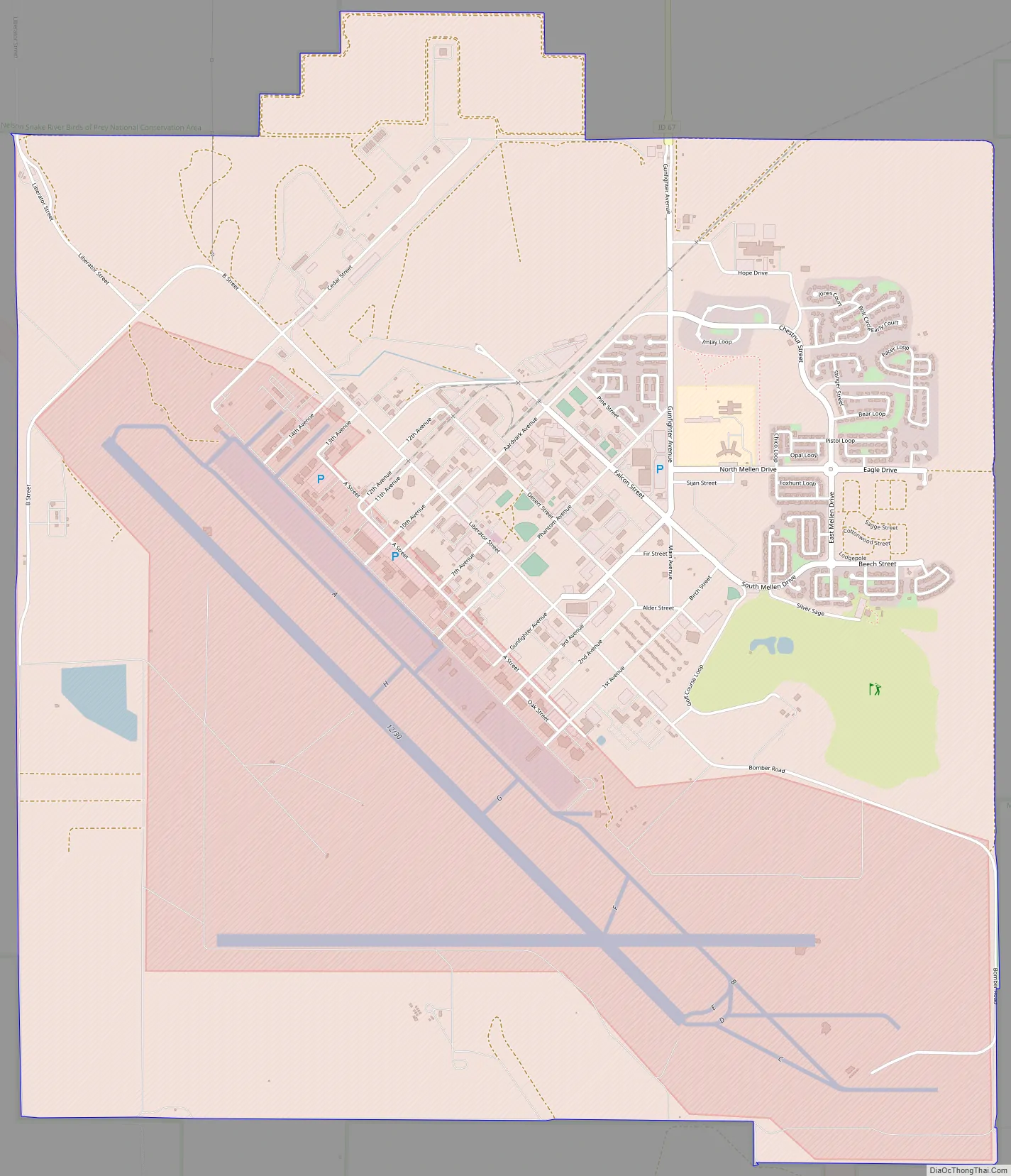
Online Interactive Map
Click on ![]() to view map in "full screen" mode.
to view map in "full screen" mode.
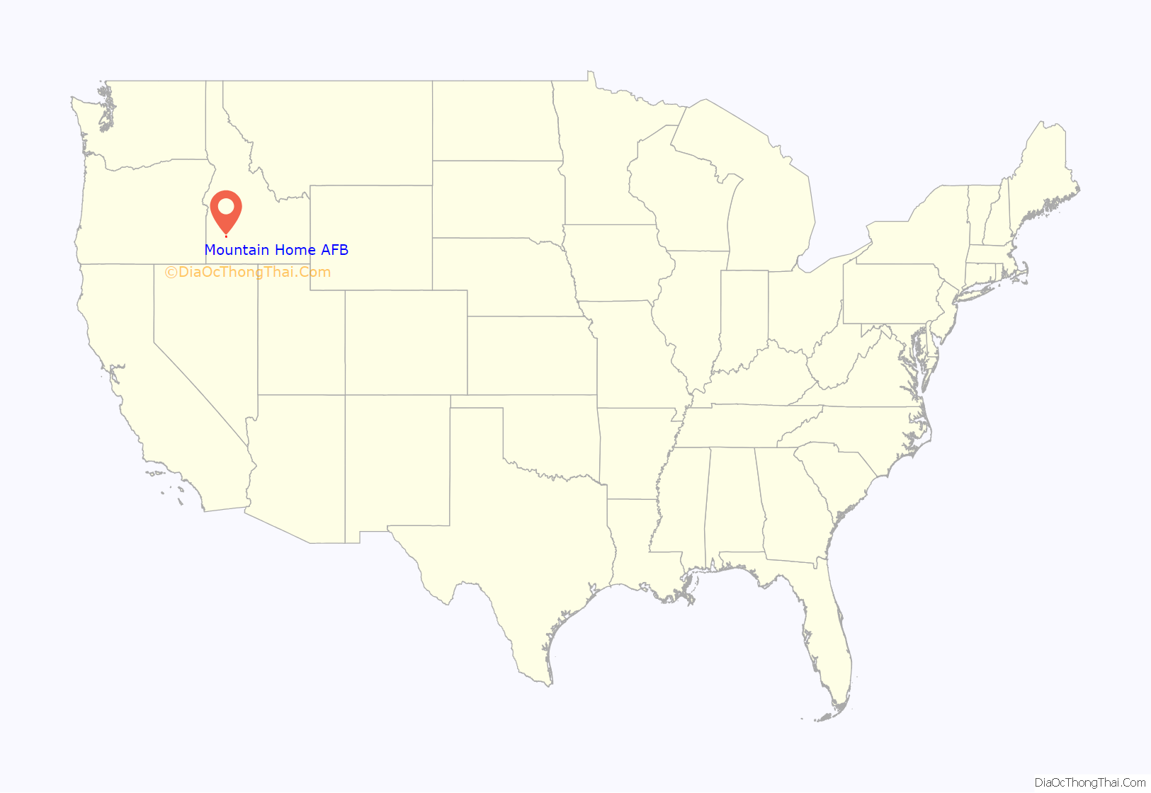
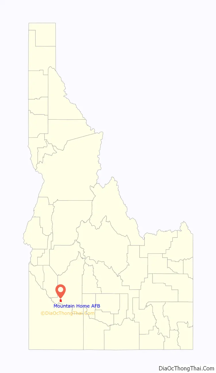
Mountain Home AFB location map. Where is Mountain Home AFB CDP?
History
Crews started building the base in November 1942 and the new field officially opened on 7 August 1943. Shortly thereafter, airmen at the field began training U.S. Army Air Forces crews for World War II. The 396th Bombardment Group (Heavy) was the first unit assigned and its planned mission was to train crews for the B-17 Flying Fortress. However, before the first B-17s arrived, plans for the field changed and the 396th was transferred to Moses Lake AAF, Washington.
Instead of training B-17 crews, Mountain Home airmen began training crews for the B-24 Liberator. The first group to do so was the 470th Bombardment Group (Heavy), which trained at Mountain Home from May 1943 until January 1944, when the unit moved to Tonopah AAF Nevada. The 490th Bombardment Group (Heavy) replaced the 470th and trained B-24 crews until it deployed to RAF Eye England in April 1944. The 494th Bombardment Group then replaced the 490th, once more training Liberator crews.
The base was placed in inactive status in October 1945.
Postwar era
The base remained inactive for over three years, until December 1948, when the newly independent U.S. Air Force reopened the base. The 4205th Air Base Group, was activated on 12 December to prepare the newly re-designated Mountain Home Air Force Base for operational use.
Three wings of the Air Resupply and Communications Service used the base in the early 1950s.
In 1953, the base was transferred to Strategic Air Command (SAC), which assigned its 9th Bombardment Wing to Mountain Home. The 9th relocated to Mountain Home AFB in May 1953, and began flying B-29 bombers and KB-29H refueling aircraft. The 9th began converting to the new B-47 Stratojet bomber and the KC-97 tanker in September 1954, keeping alert bombers ready for war at a moments notice and continuing its mission as a deterrent force throughout the Cold War years of the 1950s and early 1960s.
In 1959, construction of three SM-68 Titan missile sites began in the local area, and missiles arrived in April 1962. The 569th Strategic Missile Squadron controlled these sites and was assigned to the 9th Bombardment Wing in August 1962. To prepare for the addition of missiles to its bomber forces, it was redesignated the 9th Strategic Aerospace Wing in April 1962.
A few years later, SAC’s mission at Mountain Home began to wind down, and in November 1964, the U.S. Air Force announced that the missile sites would close by mid-1965, part of a major round of base closures announced by Secretary of Defense Robert McNamara. Other closures in the region were also USAF facilities: the Cottonwood radar station in north central Idaho and SAC’s Larson AFB, a B-52E Stratofortress (and KC-135A Stratotanker) installation in eastern Washington at Moses Lake.
In late 1965, the USAF also began phasing out the aging B-47 and announced plans to bring the 67th Tactical Reconnaissance Wing to Mountain Home, transferring the base from SAC to the Tactical Air Command (TAC) in early 1966.
366th Fighter Wing
The 366th Fighter Wing (in various designations) has been the host unit at Mountain Home for over 50 years, following its return from the Vietnam War in late 1972.
Before the 366th Tactical Fighter Wing’s arrival at Mountain Home, the 389th, 390th, and 391st Tactical Fighter Squadrons had returned from South Vietnam, joined the 347th, and began converting to F-111A Aardvark aircraft. For the first time since it left for Vietnam, the wing once again had its three original flying units.
During 1969, a tenant unit began operating at the south end of the base, using part of the original SAC alert area, and about half of the Mole Hole alert facility, sharing the other half with an NCO leadership school from the main base. Det. 1, 320 BW carried out an alert mission with two B-52 bombers and two KC-135 tankers. The unit disbanded in the spring of 1975 and returned to Mather AFB.
Operations continued unchanged for several years. The wing tested its readiness in August 1976 when a border incident in Korea prompted the U.S. to augment its military contingent in South Korea as a show of force. The 366th deployed a squadron of 20 F-111 fighters, which reached South Korea only 31 hours after receiving launch notification. Tensions eased shortly afterward and the detachment returned home.
In early 1991, the USAF announced that the 366th would become the Air Force’s premier “air intervention” composite wing. The wing would grow with the addition of a squadron of EF-111A Raven electronic warfare aircraft and a squadron of B-1B Lancer bombers to become a dynamic, five squadron wing with the ability to deploy rapidly and deliver integrated combat airpower.
The air intervention composite wing’s rapid transition from concept to reality began in October 1991 when the USAF redesignated the wing as the 366th Wing. The wing’s newly reactivated “fighter squadrons” became part of the composite wing in March 1992. The 389th Fighter Squadron began flying the dual-role F-16C Fighting Falcon, while the 391st Fighter Squadron was equipped with the new F-15E Strike Eagle. These two squadrons provide the Gunfighters round-the-clock precision strike capability.
Following the terrorist attacks on 11 September 2001, the resultant initiation of Operation Enduring Freedom, the 366th Wing once again got the call. While the 34th Bomb Squadron deployed to Diego Garcia as the B-1 component of the 28th Air Expeditionary Wing, the wing sent a Base Operations Support package to Al Udeid Air Base, Qatar, to transform the bare base into a fully functional airfield for large-scale combat operations. In October 2001, the 391st Fighter Squadron deployed to Al Jaber Air Base, Kuwait, while the 389th Fighter Squadron went to Al Udeid in November.
Following the wing’s return from Southwest Asia, the USAF began consolidating its B-1 Lancer and KC-135 Stratotanker forces. This led to the reallocation of the wing’s bombers and tankers. The 22 ARS’ aircraft began transferring to McConnell AFB, Kansas, in May 2002 and the squadron inactivated the following August. The 34 BS’ B-1Bs began moving to Ellsworth AFB, South Dakota, in June and the squadron officially moved in September. Following the departure of these assets, the USAF re-designated the 366th as a Fighter Wing. With these changes, the wing’s 10-year mission as the Air Force’s only standing air expeditionary wing came to an end. A continued reconstruction of the 366 Fighter Wing was official with the 2005 base realignment, coinciding with the large scale integration of the 150+ F-22 Raptors. After the F-16 departure, Mountain Home AFB was chosen to become an F-15E installation because of its ideal training terrain range that is suited for air-to-ground, and air-to-air training missions.
The base was the site of a Thunderbirds crash on 14 September 2003 in which no one was killed. Captain Chris Stricklin, flying Thunderbird 6 (opposing solo, serial #87-0327), attempted a “Split S” maneuver (which he had performed over 200 times) immediately after takeoff based on an incorrect mean-sea-level elevation. Similar in desert appearance, Mountain Home AFB is 1,100 feet (340 m) higher than the Thunderbirds’ home at Nellis AFB near Las Vegas, Nevada.
Climbing to only 1,670 ft (510 m) above ground level (AGL) instead of 2,500 ft (760 m), Stricklin had insufficient altitude to complete the descending half-loop maneuver. He guided the F-16C aircraft down runway 30, away from the spectators and ejected less than one second before impact. His parachute deployed when he was just above the ground and Stricklin survived with only minor injuries. No one on the ground was injured, but the $20 million aircraft was destroyed.
Official procedure for demonstration “Split-S” maneuvers was changed, and the USAF now requires Thunderbird pilots and airshow ground controllers to both work in above mean-sea-level (AMSL) altitudes, as opposed to ground control working in AGL and pilots in AMSL, which led to two sets of numbers that had to be reconciled by the pilot. Thunderbird pilots now also climb an extra 1,000 ft (300 m) before performing the Split S maneuver.
On June 24th 2022, nineteen Air Force ROTC cadets were participating in a training exercise at the base when there was an accident involving a Humvee. One cadet, nineteen-year-old Mackenzie Wilson, was pronounced dead on the scene while two other cadets were taken to nearby St. Alphonsus Hospital and treated for injuries.
After an investigation by the Idaho State Police with assistance from the Air Force Office of Special Investigations, it was discovered that the Humvees the cadets were driving were not authorized for use as transportation and did not meet the Air Force standards for maintenance. The investigator of the case told the bomb range manager, who had let the cadets drive the Humvees unsupervised on their final day of training, that he was suspected for the crime of misusing government property. An ROTC officer who had been supervising the group during the week was also informed he was suspected of dereliction of duty under the military code.
Previous names
- Army Air Base, Mountain Home, Nov 1942
- Mountain Home Army Air Field, 2 Dec 1943.
- Mountain Home Air Force Base, 13 Jan 1948 – present
Major commands to which assigned
- Second Air Force, 29 August 1942
- Fourth Air Force, 15 February 1945
- Continental Air Forces, 16 April 1945
- Strategic Air Command, 21 March 1946
- Military Air Transport Service, 24 January 1951
- Strategic Air Command, 1 May 1953
- Tactical Air Command, 1 January 1966
- Air Combat Command, 1 June 1992 – present
Major units assigned
Intercontinental ballistic missile facilities
The 569th Strategic Missile Squadron Operated three HGM-25A Titan I ICBM sites: (1 Jun 1961 – 25 Jun 1965). The first missiles arrived in April 1962.
Mountain Home AFB Road Map
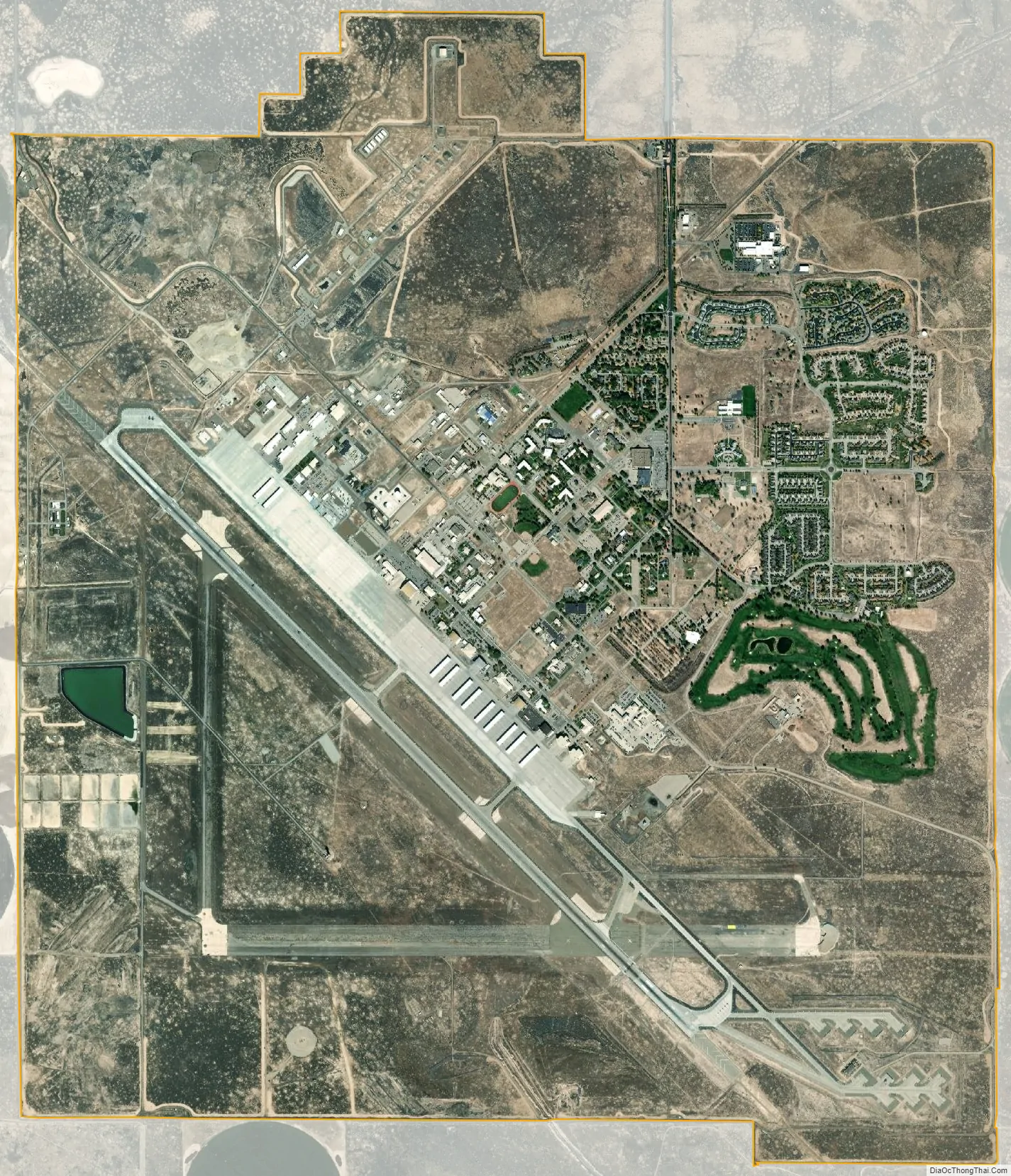
Mountain Home AFB city Satellite Map
Geography
Mountain Home AFB is located at (43.049511, −115.866452), at an elevation of 2,996 ft (913 m) above sea level. It is in the western portion of the Snake River Plain, about 3 miles (5 km) north of C. J. Strike Reservoir, an impoundment of the Snake River (and Bruneau River).
According to the United States Census Bureau, the CDP has a total area of 9.9 sq mi (26 km), and 0.10% is water.
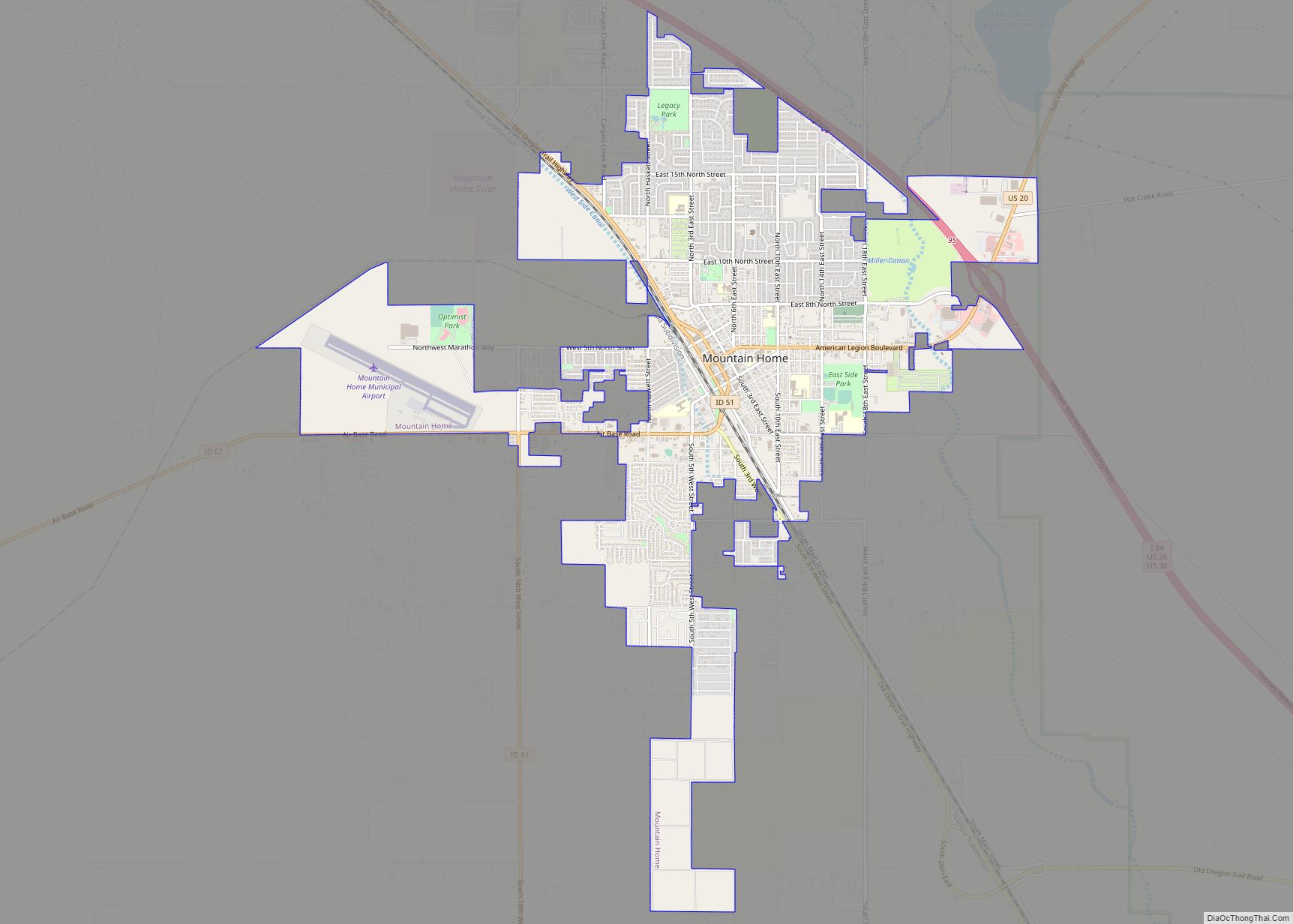
It is connected to the city of Mountain Home by State Highway 67.
See also
Map of Idaho State and its subdivision:- Ada
- Adams
- Bannock
- Bear Lake
- Benewah
- Bingham
- Blaine
- Boise
- Bonner
- Bonneville
- Boundary
- Butte
- Camas
- Canyon
- Caribou
- Cassia
- Clark
- Clearwater
- Custer
- Elmore
- Franklin
- Fremont
- Gem
- Gooding
- Idaho
- Jefferson
- Jerome
- Kootenai
- Latah
- Lemhi
- Lewis
- Lincoln
- Madison
- Minidoka
- Nez Perce
- Oneida
- Owyhee
- Payette
- Power
- Shoshone
- Teton
- Twin Falls
- Valley
- Washington
- Alabama
- Alaska
- Arizona
- Arkansas
- California
- Colorado
- Connecticut
- Delaware
- District of Columbia
- Florida
- Georgia
- Hawaii
- Idaho
- Illinois
- Indiana
- Iowa
- Kansas
- Kentucky
- Louisiana
- Maine
- Maryland
- Massachusetts
- Michigan
- Minnesota
- Mississippi
- Missouri
- Montana
- Nebraska
- Nevada
- New Hampshire
- New Jersey
- New Mexico
- New York
- North Carolina
- North Dakota
- Ohio
- Oklahoma
- Oregon
- Pennsylvania
- Rhode Island
- South Carolina
- South Dakota
- Tennessee
- Texas
- Utah
- Vermont
- Virginia
- Washington
- West Virginia
- Wisconsin
- Wyoming