Map of Carbondale city, Illinois
Carbondale is a city in Jackson County, Illinois, United States, within the Southern Illinois region informally known as “Little Egypt”. The city developed from 1853 because of the stimulation of railroad construction into the area. Today, the major roadways of Illinois Route 13 and U.S. Route 51 intersect in the city. The city is 96 ... Read more
Map of Carbondale city, Illinois
Map of Cave-In-Rock village
Cave-In-Rock is a village in Hardin County, Illinois, United States. Its principal feature and tourist attraction is nearby Cave-In-Rock, on the banks of the Ohio River. In 1816, the earliest known permanent white settlers arrived and started building a town near the cave. The town was originally known as Rock and Cave, Illinois, with a ... Read more
Map of Cave-In-Rock village
Map of Catlin village
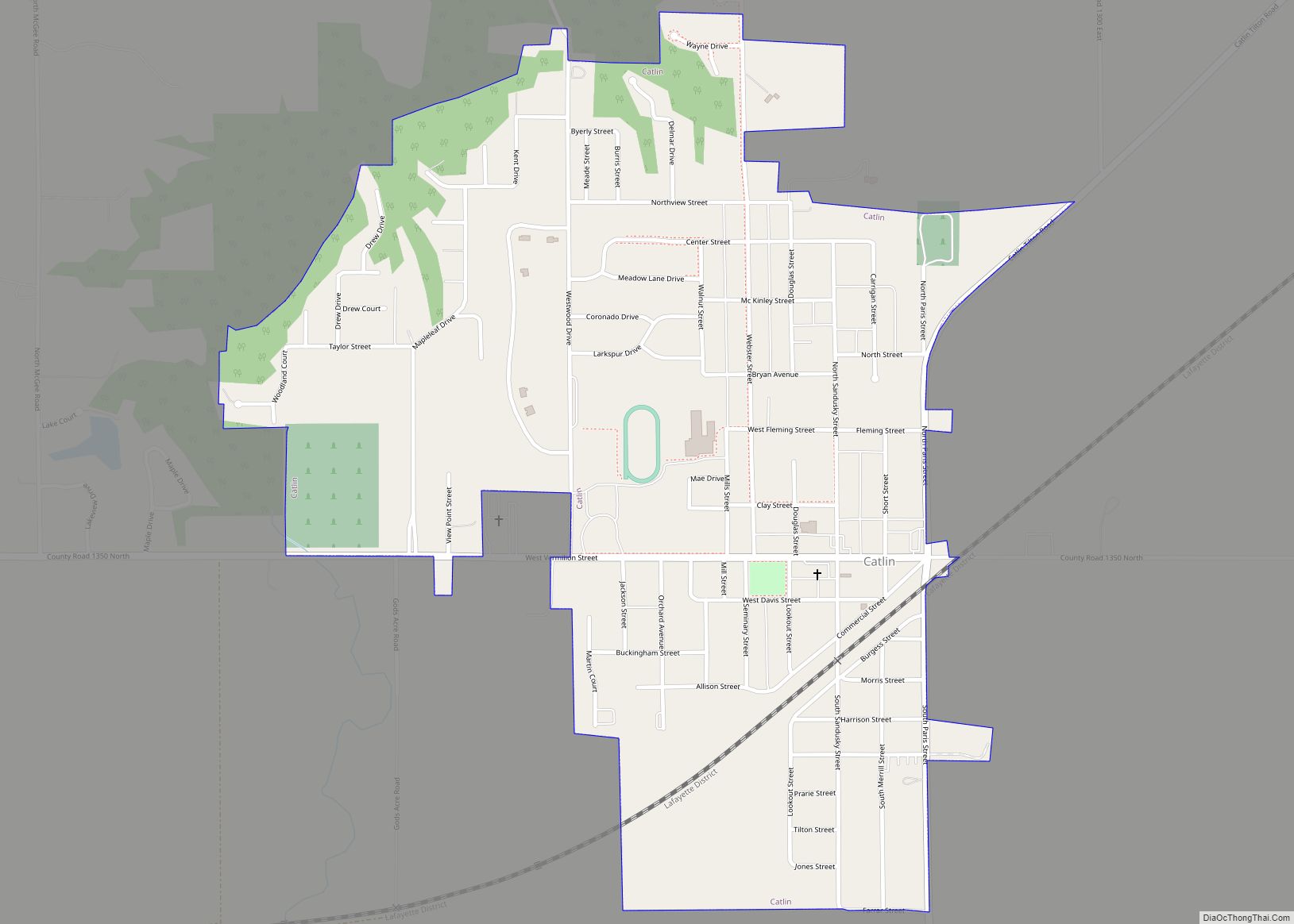
Catlin is a village in Vermilion County, Illinois, United States. It is part of the Danville, Illinois Metropolitan Statistical Area. The population was 2,040 at the 2010 census, and 1,952 in 2018. Catlin is the hometown of Illinois State Representative Chad Hays, who represents the 104th Representative District of Illinois. Catlin village overview: Name: Catlin ... Read more
Map of Catlin village
Map of Caseyville village
Caseyville is a village in St. Clair County, Illinois, United States. The population was 4,245 at the 2010 census, a decline from 4,310 in 2000. Caseyville village overview: Name: Caseyville village LSAD Code: 47 LSAD Description: village (suffix) State: Illinois County: St. Clair County Elevation: 420 ft (130 m) Total Area: 7.43 sq mi (19.24 km²) Land Area: 7.27 sq mi (18.83 km²) ... Read more
Map of Caseyville village
Map of Casey city, Illinois
Casey (pronounced CAY-see) is a city in Clark and Cumberland counties in the U.S. state of Illinois. The population was 2,404 at the 2020 census. The Cumberland County portion of Casey is part of the Charleston–Mattoon Micropolitan Statistical Area. Casey is the home to several Guinness World Record constructions – super-sized items in the form ... Read more
Map of Casey city, Illinois
Map of Cary village, Illinois
Cary is a village located in Algonquin Township, McHenry County, Illinois, and Cuba Township, Lake County, Illinois, United States. Per the 2020 census, the population was 17,826. Cary village overview: Name: Cary village LSAD Code: 47 LSAD Description: village (suffix) State: Illinois County: McHenry County Founded: 1833 Elevation: 823 ft (251 m) Total Area: 6.60 sq mi (17.10 km²) Land ... Read more
Map of Cary village, Illinois
Map of Carthage city, Illinois
Carthage is a city in and the county seat of Hancock County, Illinois, United States. Its population was 2,490 as of the 2020 census. Carthage is best known for being the site of the 1844 death of Joseph Smith, who founded the Latter Day Saint movement. Carthage city overview: Name: Carthage city LSAD Code: 25 ... Read more
Map of Carthage city, Illinois
Map of Carterville city, Illinois
Carterville is a city in Williamson County, Illinois, United States. At the 2020 census, the city’s population was 5,848. The city is part of the Carbondale-Marion-Herrin combined statistical area and has grown considerably as a residential community of Carbondale and Marion. The city is located next to Crab Orchard National Wildlife Refuge. The Refuge’s 44,000 ... Read more
Map of Carterville city, Illinois
Map of Carrollton city, Illinois
Carrollton is a city in and the county seat of Greene County, Illinois, United States. The population was 2,484 as of the 2010 census. Carrollton city overview: Name: Carrollton city LSAD Code: 25 LSAD Description: city (suffix) State: Illinois County: Greene County Elevation: 607 ft (185 m) Total Area: 1.90 sq mi (4.93 km²) Land Area: 1.90 sq mi (4.93 km²) Water Area: ... Read more
Map of Carrollton city, Illinois
Map of Carrier Mills village
Carrier Mills, formerly Carrier’s Mills and Morrilsville, also known as Catskin, is a village in Saline County, Illinois, United States. The population was 1,672 at the 2020 census. Carrier Mills was named after George Washington Carrier’s saw and grist mills, and was one of the early Cairo and Vincennes Railroad boomtowns. Founded as a mill ... Read more
Map of Carrier Mills village
Map of Carpentersville village
Carpentersville is a village in Kane County, Illinois, United States. The population was 37,983 at the 2020 census. Carpentersville village overview: Name: Carpentersville village LSAD Code: 47 LSAD Description: village (suffix) State: Illinois County: Kane County Total Area: 8.08 sq mi (20.93 km²) Land Area: 7.87 sq mi (20.39 km²) Water Area: 0.21 sq mi (0.54 km²) Total Population: 37,983 Population Density: 4,824.46/sq mi (1,862.82/km²) ... Read more
Map of Carpentersville village
Map of Carol Stream village
Carol Stream is a village in DuPage County, Illinois, United States, and a suburb of Chicago. Carol Stream was incorporated on January 5, 1959, and named after its founder’s daughter. Per the 2020 census, the population was 39,854. Carol Stream village overview: Name: Carol Stream village LSAD Code: 47 LSAD Description: village (suffix) State: Illinois ... Read more
Map of Carol Stream village