Carlyle is a city in Clinton County, Illinois, United States. The population was 3,253 at the 2020 census. It is the county seat of Clinton County.
Carlyle is located approximately 50 miles (80 km) east of St. Louis, Missouri, and is home to Illinois’ largest man-made lake, Carlyle Lake, and to the General Dean Suspension Bridge, a suspension bridge that is the only one of its kind in Illinois and crosses the Kaskaskia River.
| Name: | Carlyle city |
|---|---|
| LSAD Code: | 25 |
| LSAD Description: | city (suffix) |
| State: | Illinois |
| County: | Clinton County |
| Elevation: | 469 ft (143 m) |
| Total Area: | 3.43 sq mi (8.87 km²) |
| Land Area: | 3.42 sq mi (8.87 km²) |
| Water Area: | 0.00 sq mi (0.00 km²) |
| Total Population: | 3,253 |
| Population Density: | 949.78/sq mi (366.76/km²) |
| Area code: | 618 |
| FIPS code: | 1711228 |
| GNISfeature ID: | 2393749 |
| Website: | carlylelake.com |
Online Interactive Map
Click on ![]() to view map in "full screen" mode.
to view map in "full screen" mode.
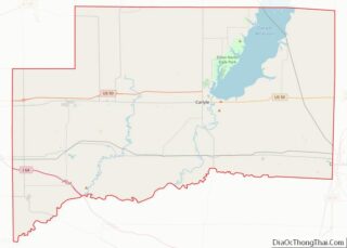
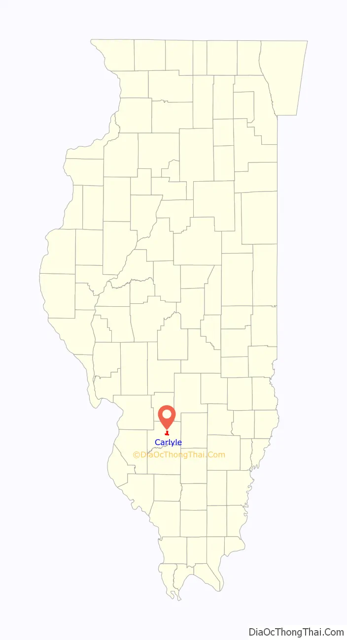
Carlyle location map. Where is Carlyle city?

History
In 1811 or 1812, a man named John Hill built one of several “block” houses along the Goshen Trail, located at what is currently 201 Fairfax Street. The houses were reportedly built to serve as a line of defense against Native Americans. John Hill built the first house to be located in what has become Carlyle. He also established what could be considered Carlyle’s first business: a ferry to carry traffic across the Kaskaskia River, including a small shelter at the river which served as a toll house.
In 1816, Charles Slade and two of his brothers reached the John Hill settlement and bought him out. Charles farmed the land, took over the ferry, and within a year partnered with a man named Hubbard to start the first store, a mercantile business located at what is now 301 Fairfax Street. In 1818, a man named Calvin Barnes laid out town lots. On March 10, 1819, a post office was first established under the name Carlisle, Illinois. This spelling might have been a clerical error.
The area was settled after the 1809 creation of the Illinois Territory but before Illinois achieved statehood, six to seven years after John Hill had already built his establishment. Illinois’ first state capitol was located in Kaskaskia, but in 1820 the state decided that it should be moved. Carlyle lost to Vandalia by one vote. In 1824, the State of Illinois created Clinton County by carving it out of Washington, Bond, and Fayette counties. Carlyle was to be the county seat should land be donated for this purpose. Charles Slade donated 20 acres (8.1 ha) of property so that the county seat would be located in Carlyle.
Carlyle was founded in 1818 by Charles W. Slade, father of Joseph “Jack” Slade, who named the town after his grandmother’s family. It was incorporated as a town on 2/10/1837 and incorporated as a city on 4/17/1884. Carlyle celebrated 150 years and used the 1837 date.
Charles Slade pushed hard for Carlyle to become the state capital of Illinois, but lost by one vote to Vandalia in 1819. In 1824, Clinton County was formed, and Carlyle became the county seat in July 1825, both at the initiative of Charles Slade.
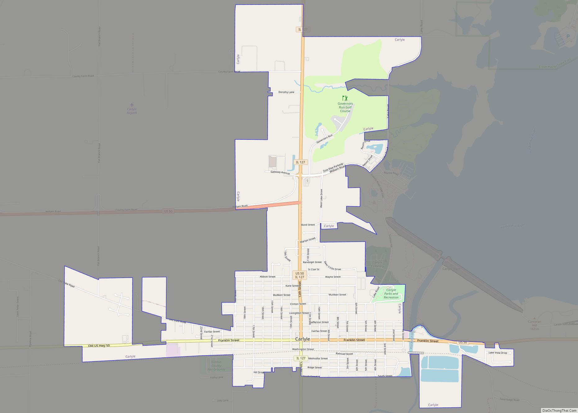
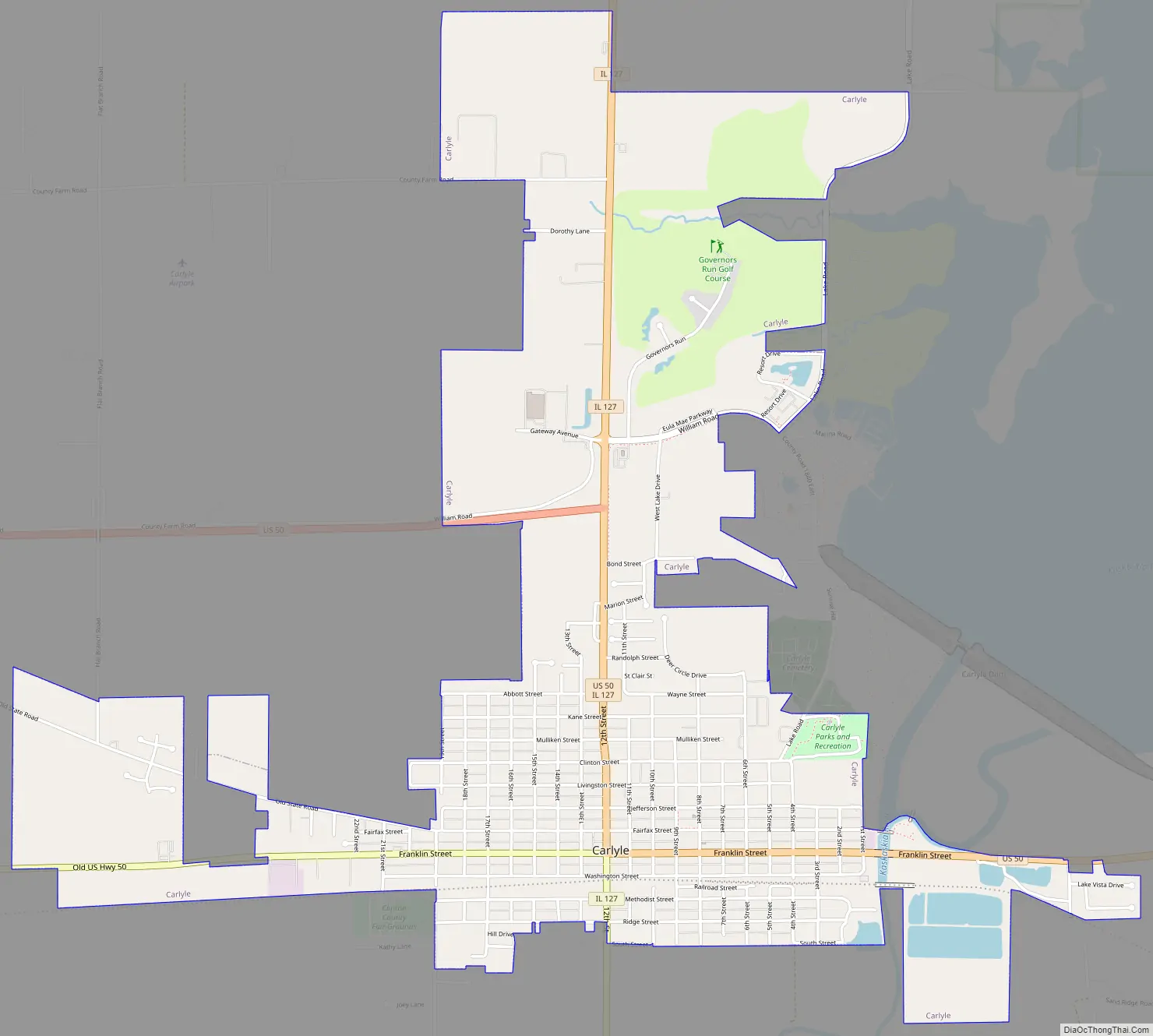
Carlyle Road Map
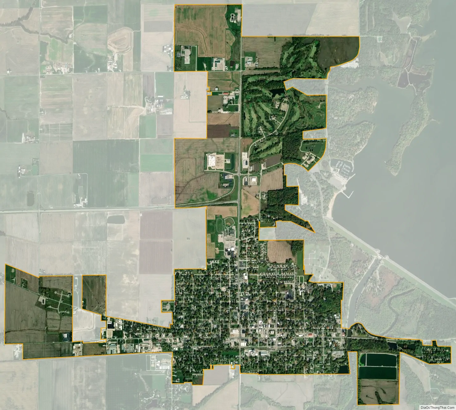
Carlyle city Satellite Map
Geography
Carlyle is located slightly east of the center of Clinton County at 38°36′46″N 89°22′15″W / 38.61278°N 89.37083°W / 38.61278; -89.37083 (38.612642, -89.370789). The Kaskaskia River flows through the easternmost part of the city out of Carlyle Dam, located just northeast of the city limits and which impounds Carlyle Lake, the largest lake wholly in Illinois.
U.S. Route 50 passes through the city, leading east 23 miles (37 km) to Salem and west 50 miles (80 km) to St. Louis. Illinois Route 127 leads north 21 miles (34 km) to Greenville and south 19 miles (31 km) to Nashville, Illinois. The General Dean Suspension Bridge, built in 1859 and named after Major General William F. Dean in 1953, crosses the Kaskaskia River just north of the current US 50 bridge.
According to the 2021 census gazetteer files, Carlyle has a total area of 3.43 square miles (8.88 km), of which 3.43 square miles (8.88 km) (or 99.97%) is land and 0.00 square miles (0.00 km) (or 0.03%) is water.
See also
Map of Illinois State and its subdivision:- Adams
- Alexander
- Bond
- Boone
- Brown
- Bureau
- Calhoun
- Carroll
- Cass
- Champaign
- Christian
- Clark
- Clay
- Clinton
- Coles
- Cook
- Crawford
- Cumberland
- De Kalb
- De Witt
- Douglas
- Dupage
- Edgar
- Edwards
- Effingham
- Fayette
- Ford
- Franklin
- Fulton
- Gallatin
- Greene
- Grundy
- Hamilton
- Hancock
- Hardin
- Henderson
- Henry
- Iroquois
- Jackson
- Jasper
- Jefferson
- Jersey
- Jo Daviess
- Johnson
- Kane
- Kankakee
- Kendall
- Knox
- La Salle
- Lake
- Lake Michigan
- Lawrence
- Lee
- Livingston
- Logan
- Macon
- Macoupin
- Madison
- Marion
- Marshall
- Mason
- Massac
- McDonough
- McHenry
- McLean
- Menard
- Mercer
- Monroe
- Montgomery
- Morgan
- Moultrie
- Ogle
- Peoria
- Perry
- Piatt
- Pike
- Pope
- Pulaski
- Putnam
- Randolph
- Richland
- Rock Island
- Saint Clair
- Saline
- Sangamon
- Schuyler
- Scott
- Shelby
- Stark
- Stephenson
- Tazewell
- Union
- Vermilion
- Wabash
- Warren
- Washington
- Wayne
- White
- Whiteside
- Will
- Williamson
- Winnebago
- Woodford
- Alabama
- Alaska
- Arizona
- Arkansas
- California
- Colorado
- Connecticut
- Delaware
- District of Columbia
- Florida
- Georgia
- Hawaii
- Idaho
- Illinois
- Indiana
- Iowa
- Kansas
- Kentucky
- Louisiana
- Maine
- Maryland
- Massachusetts
- Michigan
- Minnesota
- Mississippi
- Missouri
- Montana
- Nebraska
- Nevada
- New Hampshire
- New Jersey
- New Mexico
- New York
- North Carolina
- North Dakota
- Ohio
- Oklahoma
- Oregon
- Pennsylvania
- Rhode Island
- South Carolina
- South Dakota
- Tennessee
- Texas
- Utah
- Vermont
- Virginia
- Washington
- West Virginia
- Wisconsin
- Wyoming