Carrier Mills, formerly Carrier’s Mills and Morrilsville, also known as Catskin, is a village in Saline County, Illinois, United States. The population was 1,672 at the 2020 census. Carrier Mills was named after George Washington Carrier’s saw and grist mills, and was one of the early Cairo and Vincennes Railroad boomtowns. Founded as a mill town and then a coal mining community, Carrier Mills has slowly lost 44% of its population since the 1920 census high of 3,000, due to the shuttering of the local coal industry. The village has primarily become a bedroom community, located seven miles (11 km) southwest of Harrisburg, which is the village’s main source of employment, entertainment, and shopping. It is the third largest community in the Harrisburg Micropolitan Statistical Area outside of Eldorado and Harrisburg, and included in the Illinois-Indiana-Kentucky Tri-State Area. Carrier Mills also has a large African American population at 15%, compared to its neighbors, due to migration from the nearby community of Lakeview, the oldest African American settlement in the state of Illinois.
The village is host to the annual Catskin Days Fair and Parade, a multi-day fall festival event in October commemorating the history and culture of the village.
| Name: | Carrier Mills village |
|---|---|
| LSAD Code: | 47 |
| LSAD Description: | village (suffix) |
| State: | Illinois |
| County: | Saline County |
| Founded: | 1872 |
| Total Area: | 1.22 sq mi (3.15 km²) |
| Land Area: | 1.21 sq mi (3.13 km²) |
| Water Area: | 0.01 sq mi (0.03 km²) |
| Total Population: | 1,672 |
| Population Density: | 1,384.11/sq mi (534.50/km²) |
| ZIP code: | 62917 |
| Area code: | Area code 618 |
| FIPS code: | 1711397 |
| Website: | www.cmsf.saline.k12.il.us/main.html |
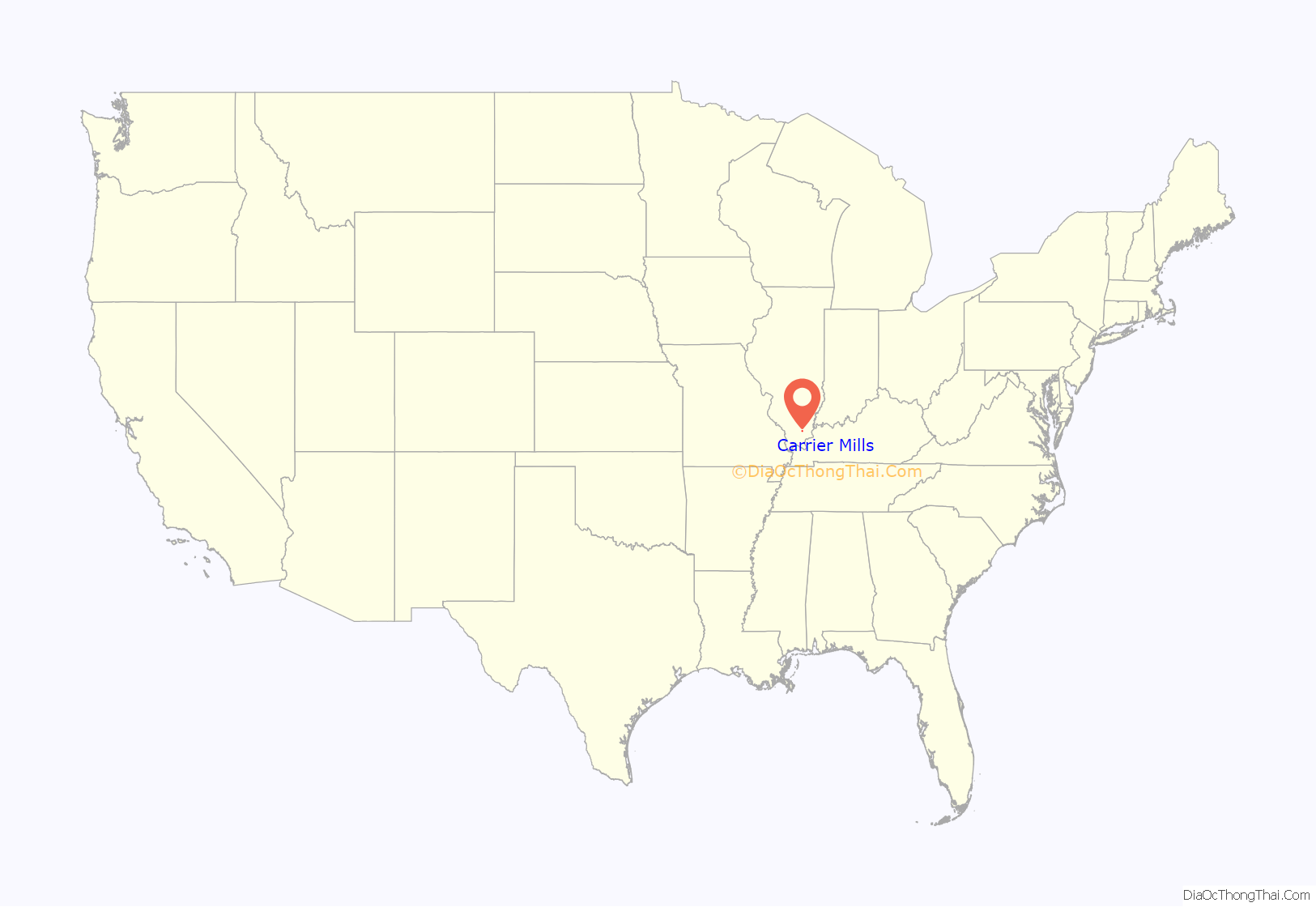
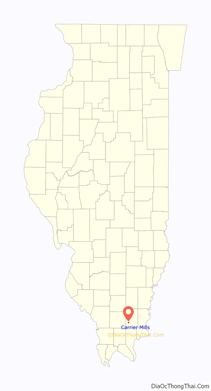
Online Interactive Map
Click on ![]() to view map in "full screen" mode.
to view map in "full screen" mode.
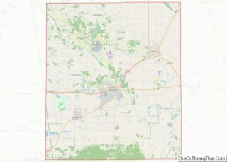
Carrier Mills location map. Where is Carrier Mills village?
History
The first settler in the village now known as Carrier Mills was Hampton Pankey. He was also one of the earliest settlers in Saline County. Pankey was living in the area in 1804 or 1805 and he registered his land deed in 1814, the earliest date that was available to register them. In about 1811 the settlers began building blockhouses for protection from American Indians. A blockhouse was built on his land around this time. Pankey had seven daughters and three sons. One of those sons was John Pankey, who was one of the founding fathers of Harrisburg.
The village was surveyed by Benjamin D Lewis and platted in November 1872 for William Housely as Morrillsville, named after H. L. Morrill, the Cairo and Vincennes Railroad superintendent who sealed a real estate deal with mill owner G. W. Carrier.
It was commonly known as, and eventually renamed, Carrier’s Mills after inventor G. Washington Carrier (“Uncle Wash”) who helped found the town when he built an elaborate steam powered saw mill and a grist mill just to the south of town on the Saline River watershed, near the old Tuller Mansion farming and property site. Carrier’s Mills was the farthest north cypress trees grew at the time, which made lumber milling in the town profitable. Carrier was the first of many to set up wood working factories within the city limits. The mills were first used for the making of lumber to construct bridges and ties for the Cairo and Vincennes Railroad, then later the businesses and homes in the town soon followed.
Carrier and Morrill closed a real estate deal to build a train depot there. The town was platted adjacent and north of the newly completed Cairo and Vincennes Railroad. In 1873, the first postmaster was appointed to Carrier’s Mills (the name the railroad had assigned to the new stop). The town’s name changed again to “Carrier Mills” when several more woodworking factories were built. The village was incorporated on September 18, 1894. After an influx of settlers from the south, due to the Civil War, the tiny village amidst timber and farms grew quickly. Today, in legal documents its name remains Morrillsville. Carrier Mills did not have a single brick building and the sidewalks were of boards. The business district was mainly on Oak Street from the First National Bank west to the Texaco Gas Station, and all of frame construction. A disastrous fire in February 1908 burned everything on the north side of Oak Street. In March 1908, fire burned everything on the south side of the street, from Main to Mill, except the Old Woolcott Mill Exchange. The businessmen began immediately to rebuild, all of brick construction.
Tuller Mansion, or “Tuller Place” was a Victorian, 1910, two-story manor, constructed of red brick from the Terre Haute Block Company built on the outskirts of town. There was a grand entry staircase with marble floors, clawfoot tubs, built-in china cabinets, and fine mahogany wood throughout. A large, elegant patio served to entertain guests in hosting social dances, and even a carport existed for the two vehicles that Tuller owned. The mansion was built on the Carrier-Vennum estate, nicknamed “Inland Farm”, by Arthur V. Tuller, inlaw of George Washington Carrier, the town’s founder. The house burned in the 1990s.
After the lumber boom died out, Coal mining had a great influence on Carrier Mills. Over one hundred coal mines were privately and publicly operated around Carrier Mills between near the turn of the 20th century and the late 1990s. from 1913 to 1933, was the southern terminus of the Southern Illinois Railway & Power Company’s Interurban Line. The trolley would take residents from downtown, and along Carline Street toward Harrisburg. During the town’s heyday, some 3,000 people bustled around the busy streets. After the coal mines closed the population dwindled to nearly 1,500 according to the 2010 census. The entire county has suffered dearly from the closing of the coal mines, making Carrier Mills a near ghost town. In 2009 Carrier Mills ended a 70-year-long prohibition. During the 2012 Leap Day tornado outbreak an EF-4 tornado touched down just north of Carrier Mills at 4:51 a.m. on February 29, 2012, destroyed a church and damaged homes along Town Park Road and then traveled ENE toward Harrisburg, where it damaged and destroyed entire neighborhoods of the city.
Local school history
The first school in Carrier Mills was a large, two-story wooden structure with a bell tower. It was built in the early 1820s and located near the old Sahara Coal Company preparation plant (now abandoned), just northwest of the village.
The little structure was made of logs and had a clay chimney. School year began in August and ended in October because of the extreme cold. A typical school in 1850 was a subscription school – a fee of $2.50 was charged for a two-month period. From the Civil War period until 1875, the only formal school was located near Salem.
In 1887, the first school building in Carrier Mills Village was purchased for the purpose of being a prescription school at the corner of Walnut and Main St. The first major public school in the town was opened in 1903 on Furlong St. The first recognized two-year high school course was started in 1915. In 1917, the high school became a registered three-year high school until 1926 when it became a community high school fully accredited by the state of Illinois.
Around 1940, the Carrier Mills Public School building burned down after a disastrous fire starting during a Boy Scout meeting in the basement. A much larger school was built a year later as a grade school around the frame of the first burnt school.
On February 4, 1938, the present High School was completed and occupied, with the gymnasium and auditorium added in 1940. The current enlarged gym was built in 1950–51. At the beginning of 1963, the small town of Stonefort joined the Carrier Mills school district creating the Carrier Mills-Stonefort Unit 2 School District.
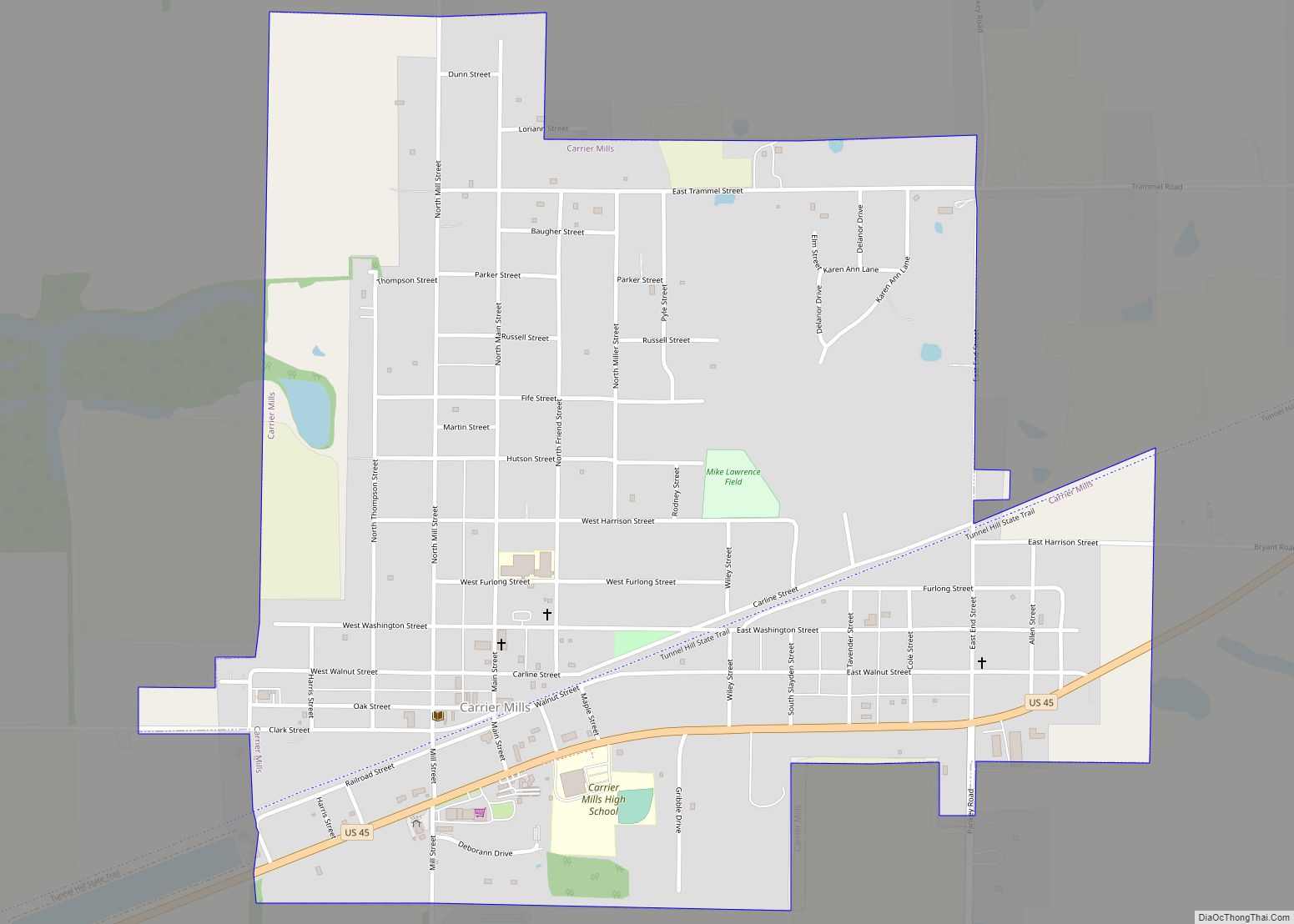
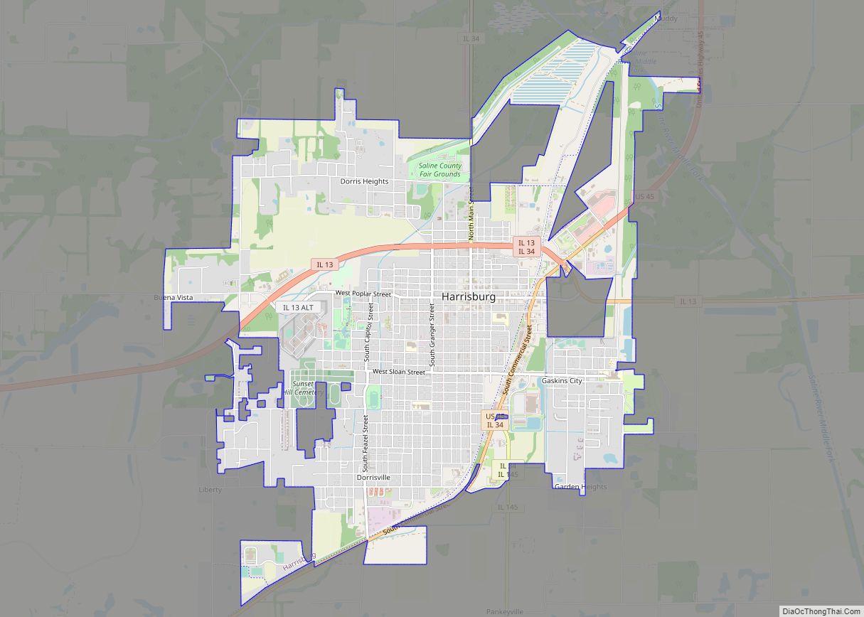
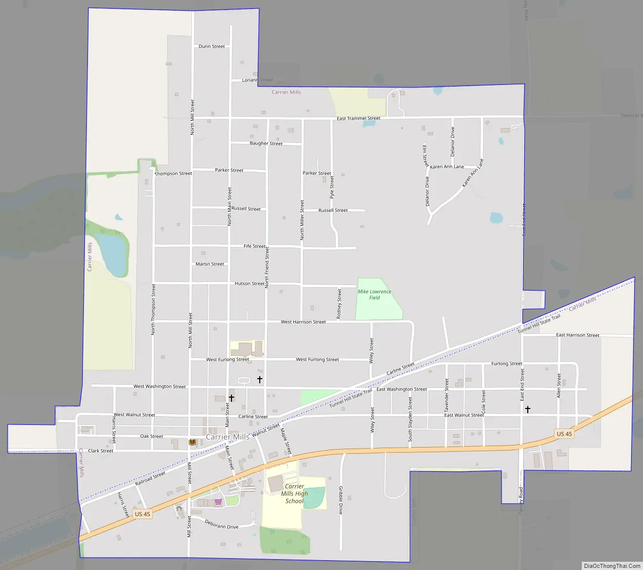
Carrier Mills Road Map
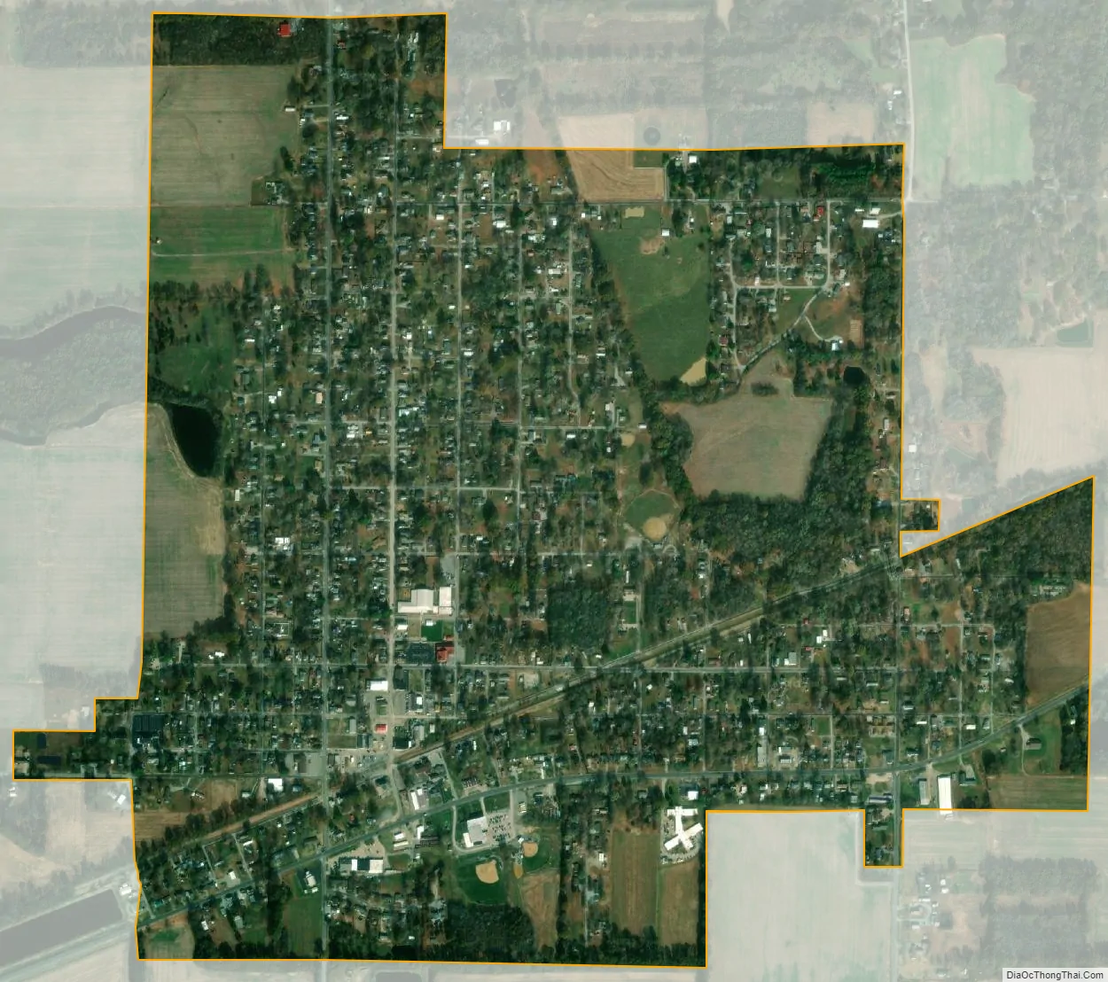
Carrier Mills city Satellite Map
Geography
Carrier Mills is located at 37°41′13″N 88°37′45″W / 37.68694°N 88.62917°W / 37.68694; -88.62917 (37.686923, -88.629149).
According to the 2010 census, Carrier Mills has a total area of 1.221 square miles (3.16 km), of which 1.21 square miles (3.13 km) (or 99.1%) is land and 0.011 square miles (0.03 km) (or 0.9%) is water.
Carrier Mills sits upon a heavily undermined hillside that overlooks a shallow flatland to the south, where its sister community of Lakeview was built in a region of swampy land drained by the South Fork of the Saline River. In the distance, two ridges of the Shawnee Hills can be seen from town in a distinct blue haze.
The village is split into two distinct sections with Washington Street being the only main east–west oriented avenue connecting them. In between the two sections is the elevated New York Central Railroad bed, now the Tunnel Hill State Trail, on a large swath of grass, and the now defunct streetcar bypass on Carline Street, splitting the village in a southwest to northeast angle. Downtown is located in the southwest corner, the largest section of the village to the northwest, and East End to the southeast, US Route 45 borders the southern edge, giving Carrier Mills its distinctive ‘L’ shape.
See also
Map of Illinois State and its subdivision:- Adams
- Alexander
- Bond
- Boone
- Brown
- Bureau
- Calhoun
- Carroll
- Cass
- Champaign
- Christian
- Clark
- Clay
- Clinton
- Coles
- Cook
- Crawford
- Cumberland
- De Kalb
- De Witt
- Douglas
- Dupage
- Edgar
- Edwards
- Effingham
- Fayette
- Ford
- Franklin
- Fulton
- Gallatin
- Greene
- Grundy
- Hamilton
- Hancock
- Hardin
- Henderson
- Henry
- Iroquois
- Jackson
- Jasper
- Jefferson
- Jersey
- Jo Daviess
- Johnson
- Kane
- Kankakee
- Kendall
- Knox
- La Salle
- Lake
- Lake Michigan
- Lawrence
- Lee
- Livingston
- Logan
- Macon
- Macoupin
- Madison
- Marion
- Marshall
- Mason
- Massac
- McDonough
- McHenry
- McLean
- Menard
- Mercer
- Monroe
- Montgomery
- Morgan
- Moultrie
- Ogle
- Peoria
- Perry
- Piatt
- Pike
- Pope
- Pulaski
- Putnam
- Randolph
- Richland
- Rock Island
- Saint Clair
- Saline
- Sangamon
- Schuyler
- Scott
- Shelby
- Stark
- Stephenson
- Tazewell
- Union
- Vermilion
- Wabash
- Warren
- Washington
- Wayne
- White
- Whiteside
- Will
- Williamson
- Winnebago
- Woodford
- Alabama
- Alaska
- Arizona
- Arkansas
- California
- Colorado
- Connecticut
- Delaware
- District of Columbia
- Florida
- Georgia
- Hawaii
- Idaho
- Illinois
- Indiana
- Iowa
- Kansas
- Kentucky
- Louisiana
- Maine
- Maryland
- Massachusetts
- Michigan
- Minnesota
- Mississippi
- Missouri
- Montana
- Nebraska
- Nevada
- New Hampshire
- New Jersey
- New Mexico
- New York
- North Carolina
- North Dakota
- Ohio
- Oklahoma
- Oregon
- Pennsylvania
- Rhode Island
- South Carolina
- South Dakota
- Tennessee
- Texas
- Utah
- Vermont
- Virginia
- Washington
- West Virginia
- Wisconsin
- Wyoming