Map of Cloverport city

Map of Cloverport city

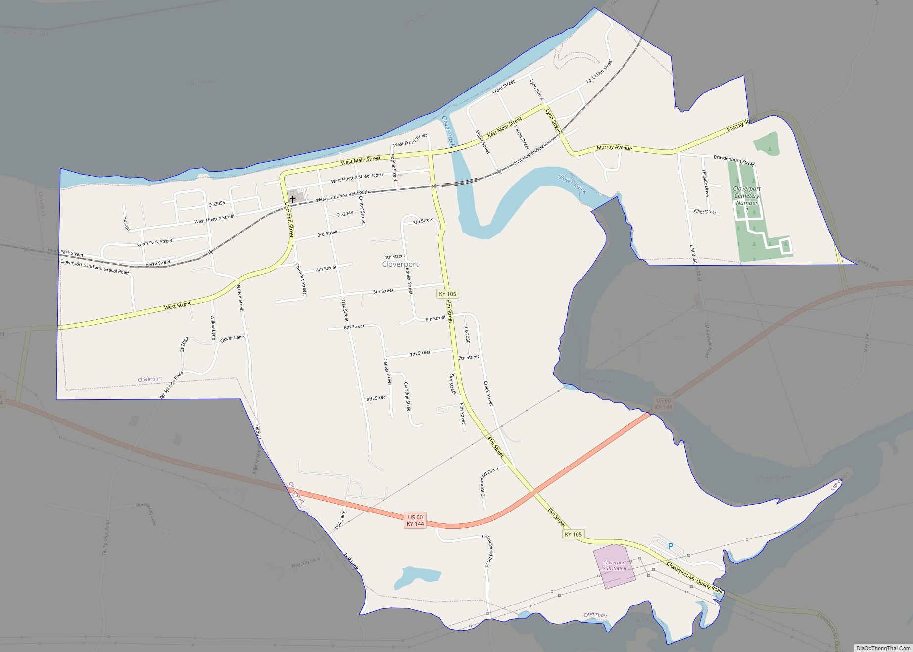
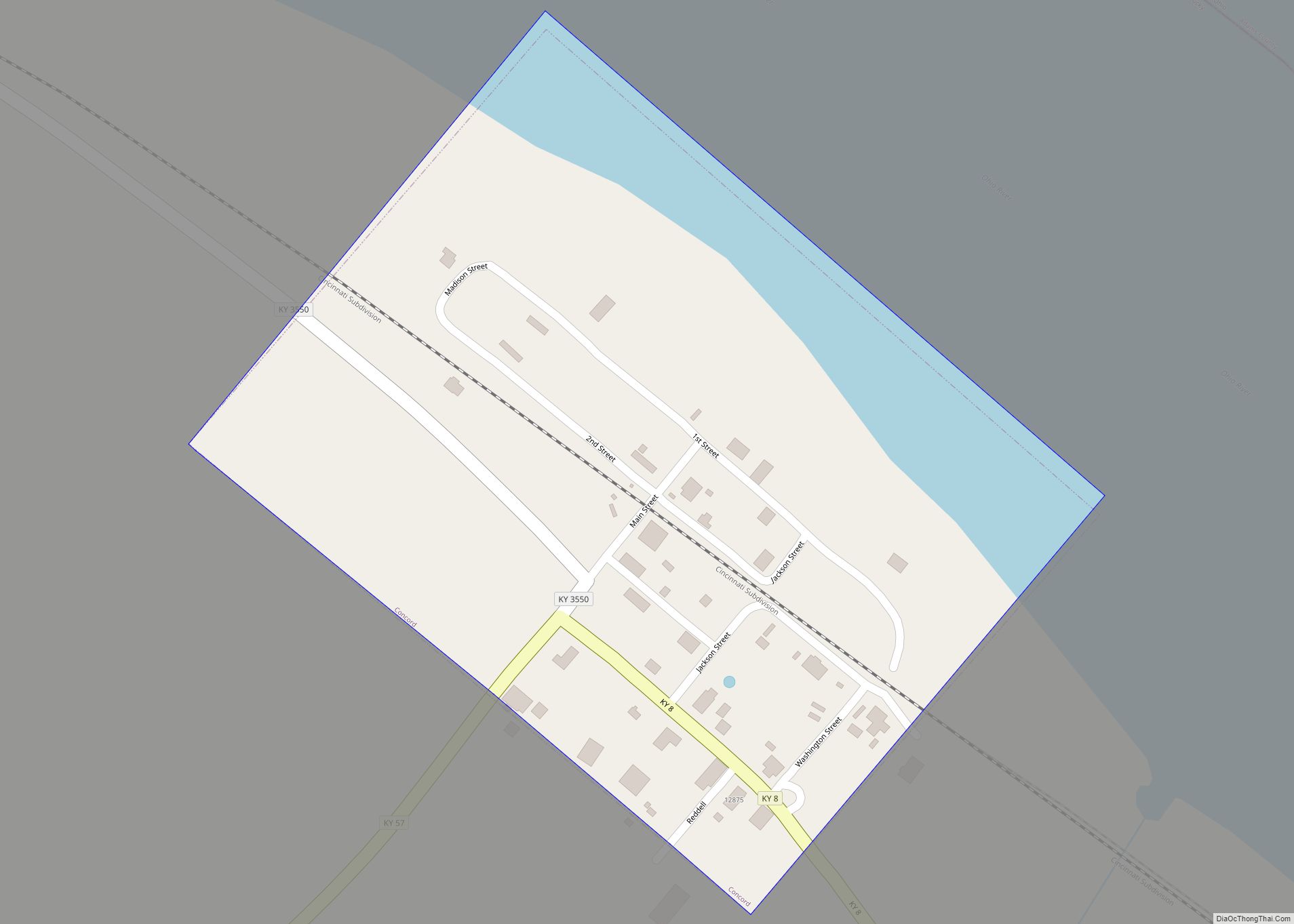
Cloverport is a home rule-class city in Breckinridge County, Kentucky, United States, on the banks of the Ohio River. The population was 1,152 at the 2010 census. Cloverport city overview: Name: Cloverport city LSAD Code: 25 LSAD Description: city (suffix) State: Kentucky County: Breckinridge County Elevation: 489 ft (149 m) Total Area: 1.52 sq mi (3.94 km²) Land Area: 1.46 sq mi … Read more

Map of Columbia city, Kentucky

Map of Columbia city, Kentucky

Columbia is a home rule-class city just above Russell Creek in Adair County, Kentucky, in the United States. The population was 4,452 at the 2010 census. Columbia is the seat of its county. Columbia city overview: Name: Columbia city LSAD Code: 25 LSAD Description: city (suffix) State: Kentucky County: Adair County Elevation: 748 ft (228 m) Total … Read more

Map of Coldstream city

Map of Coldstream city, Kentucky

Coldstream is a home rule-class city in Jefferson County, Kentucky, United States. The population was 1,100 at the 2010 census, up from 956 at the 2000 census. Coldstream city overview: Name: Coldstream city LSAD Code: 25 LSAD Description: city (suffix) State: Kentucky County: Jefferson County Elevation: 755 ft (230 m) Total Area: 0.22 sq mi (0.57 km²) Land Area: 0.22 sq mi … Read more

Map of Coldiron CDP

Map of Coldiron CDP

Coldiron is a census-designated place and unincorporated community in Harlan County, Kentucky, United States. Its population was 222 as of the 2020 census. Coldiron CDP overview: Name: Coldiron CDP LSAD Code: 57 LSAD Description: CDP (suffix) State: Kentucky County: Harlan County Elevation: 1,132 ft (345 m) Total Area: 0.24 sq mi (0.63 km²) Land Area: 0.22 sq mi (0.57 km²) Water Area: 0.03 sq mi … Read more

Map of Concord city, Kentucky

Map of Concord city, Kentucky

Concord is a home rule-class city in Lewis County, Kentucky, in the United States. The population was 35 at the 2010 census. It is part of the Maysville Micropolitan Statistical Area. Concord city overview: Name: Concord city LSAD Code: 25 LSAD Description: city (suffix) State: Kentucky County: Lewis County Elevation: 541 ft (165 m) Total Area: 0.07 sq mi … Read more

Map of Combs CDP

Map of Combs CDP

Combs is an unincorporated community and coal town within Perry County, Kentucky, United States. It was named for Abijah Benjamin Combs. At one time, the town was called Lennut; its post office, no longer existent, used this name. Combs CDP overview: Name: Combs CDP LSAD Code: 57 LSAD Description: CDP (suffix) State: Kentucky County: Perry … Read more

Map of Columbus city, Kentucky

Map of Columbus city, Kentucky

Columbus is a home rule-class city in Hickman County, Kentucky, in the United States. The population was 170 at the 2010 census, a decline from 229 in 2000. The city lies at the western end of the state, less than a mile from the Mississippi River. Columbus-Belmont State Park borders the city to the west. … Read more

Map of Corydon city, Kentucky

Map of Corydon city, Kentucky

Corydon (/ˈkɒrɪdən/) is a home rule-class city and former coal town in Henderson County, Kentucky, United States. The population was 720 at the 2010 census. Corydon city overview: Name: Corydon city LSAD Code: 25 LSAD Description: city (suffix) State: Kentucky County: Henderson County Elevation: 456 ft (139 m) Total Area: 0.54 sq mi (1.41 km²) Land Area: 0.54 sq mi (1.41 km²) Water … Read more

Map of Corinth city, Kentucky

Map of Corinth city, Kentucky

Corinth is a home rule-class city mostly in Grant County with a small portion of land in Scott County in the U.S. state of Kentucky. The population was 232 as of the 2010 census, up from 181 at the 2000 census. The Grant County portion of Corinth is part of the Cincinnati-Middletown, OH–KY–IN Metropolitan Statistical … Read more

Map of Corbin city

Map of Corbin city

Corbin is a home rule-class city in Whitley, Knox and Laurel counties in the southeastern portion of the U.S. state of Kentucky. As of the 2020 census, the city population was 7,856. Corbin is on Interstate 75 and US Route 25W, about halfway between Knoxville, Tennessee, and Lexington. Corbin city overview: Name: Corbin city LSAD … Read more

Map of Crayne CDP

Map of Crayne CDP

Crayne is a census-designated place and unincorporated community within Crittenden County, Kentucky, United States. As of the 2010 census it had a population of 173. Crayne CDP overview: Name: Crayne CDP LSAD Code: 57 LSAD Description: CDP (suffix) State: Kentucky County: Crittenden County Elevation: 640 ft (200 m) Total Area: 1.12 sq mi (2.90 km²) Land Area: 1.11 sq mi (2.89 km²) Water … Read more

Map of Crab Orchard city, Kentucky

Map of Crab Orchard city, Kentucky

Crab Orchard is a home rule-class city in Lincoln County, Kentucky, United States. The population was 841 at the 2010 census. It is part of the Danville Micropolitan Statistical Area. Crab Orchard city overview: Name: Crab Orchard city LSAD Code: 25 LSAD Description: city (suffix) State: Kentucky County: Lincoln County Elevation: 951 ft (290 m) Total Area: … Read more