Map of Sonora city, Kentucky

Map of Sonora city, Kentucky

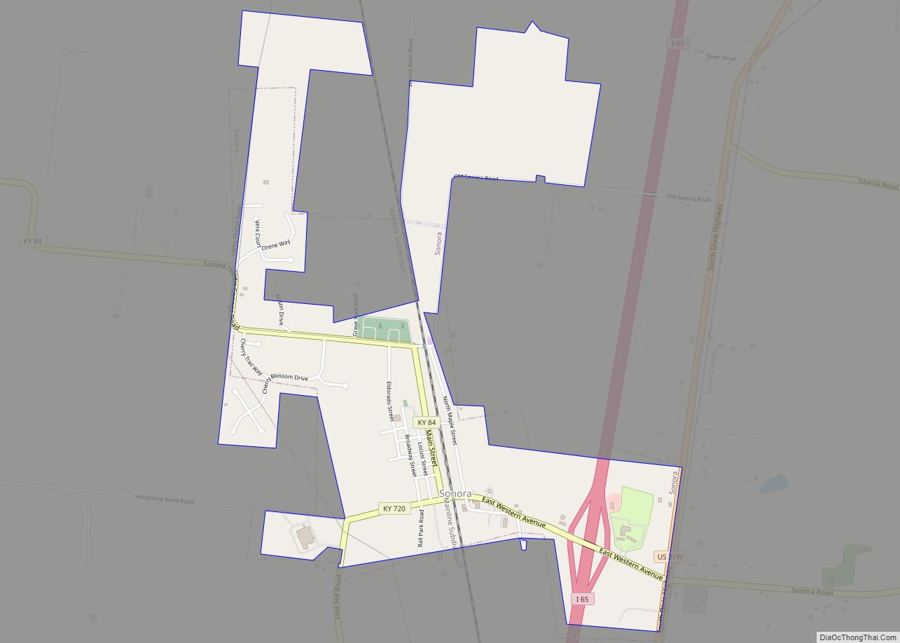
Sonora is a home rule-class city in Hardin County, Kentucky, United States. The population was 513 at the 2010 census, up from 350 at the 2000 census. It is included in the Elizabethtown, Kentucky Metropolitan Statistical Area. Sonora city overview: Name: Sonora city LSAD Code: 25 LSAD Description: city (suffix) State: Kentucky County: Hardin County … Read more

Map of South Williamson CDP

Map of South Williamson CDP

South Williamson is a census-designated place (CDP) in the Appalachian Mountains of northeastern Pike County, Kentucky, United States, on the border with West Virginia. It is separated from Williamson, West Virginia by the Tug Fork River. The community is located near U.S. Route 119 about 23 miles (37 km) east of Pikeville, Kentucky and 28 miles … Read more

Map of South Wallins CDP

Map of South Wallins CDP

South Wallins is an unincorporated community and census-designated place (CDP) in Harlan County, Kentucky, United States. The population was 859 at the 2010 census, down from 996 at the 2000 census. South Wallins CDP overview: Name: South Wallins CDP LSAD Code: 57 LSAD Description: CDP (suffix) State: Kentucky County: Harlan County Elevation: 1,142 ft (348 m) Total … Read more

Map of South Shore city

Map of South Shore city, Kentucky

South Shore is a home rule-class city in Greenup County, Kentucky, United States. The population was 1,122 at the 2010 census, down from 1,226 in 2000. It is located along the Ohio River across from Portsmouth, Ohio, at the mouth of Tygarts Creek. South Shore is a part of the Huntington-Ashland, WV-KY-OH, Metropolitan Statistical Area … Read more

Map of Spottsville CDP

Map of Spottsville CDP

Spottsville is a census-designated place (CDP) and former coal town in Henderson County, Kentucky, United States. As of the 2010 census the population was 325. U.S. Route 60 forms the northern edge of Spottsville, and the Green River forms the eastern edge. The Green River Lock & Dam is located in the community. If one … Read more

Map of Sparta city, Kentucky

Map of Sparta city, Kentucky

Sparta is a home rule-class city in Gallatin and Owen counties in the U.S. state of Kentucky. The population was 231 at the 2010 census. Sparta is home to Kentucky Speedway. Sparta city overview: Name: Sparta city LSAD Code: 25 LSAD Description: city (suffix) State: Kentucky County: Gallatin County Elevation: 509 ft (155 m) Total Area: 6.29 sq mi … Read more

Map of Southgate city, Kentucky

Map of Southgate city, Kentucky

Southgate is a home rule-class city in Campbell County, Kentucky, United States. The population was 3,803 at the 2010 census. Southgate city overview: Name: Southgate city LSAD Code: 25 LSAD Description: city (suffix) State: Kentucky County: Campbell County Elevation: 689 ft (210 m) Total Area: 1.46 sq mi (3.78 km²) Land Area: 1.46 sq mi (3.78 km²) Water Area: 0.00 sq mi (0.01 km²) Total Population: … Read more

Map of Springfield city, Kentucky

Map of Springfield city, Kentucky

Springfield is a home rule-class city in and county seat of Washington County, Kentucky, United States. The population was 2,846 at the 2020 census. Springfield city overview: Name: Springfield city LSAD Code: 25 LSAD Description: city (suffix) State: Kentucky County: Washington County Elevation: 768 ft (234 m) Total Area: 4.16 sq mi (10.78 km²) Land Area: 4.11 sq mi (10.66 km²) Water Area: … Read more

Map of Spring Valley city, Kentucky

Map of Spring Valley city, Kentucky

Spring Valley is a home rule-class city in Jefferson County, Kentucky, United States. Spring Valley Estates, begun in 1964, remained an unincorporated area until September, 1983. At that time, the City of Spring Valley was established to provide services. The current mayor is Gerri Willis. The population was 654 at the 2010 census. Population has … Read more

Map of Spring Mill city

Map of Spring Mill city

Spring Mill is a home rule-class city in Jefferson County, Kentucky, United States. The population was 287 at the 2010 census, down from 380 at the 2000 census. Spring Mill city overview: Name: Spring Mill city LSAD Code: 25 LSAD Description: city (suffix) State: Kentucky County: Jefferson County Elevation: 659 ft (201 m) Total Area: 0.06 sq mi (0.14 km²) … Read more

Map of St. Charles city, Kentucky

Map of St. Charles city, Kentucky

St. Charles is a home rule-class city in Hopkins County, Kentucky, United States. The population was 277 at the 2010 U.S. Census. St. Charles city overview: Name: St. Charles city LSAD Code: 25 LSAD Description: city (suffix) State: Kentucky County: Hopkins County Elevation: 440 ft (134 m) Total Area: 1.00 sq mi (2.59 km²) Land Area: 0.99 sq mi (2.57 km²) Water Area: … Read more

Map of St. Matthews city

Map of St. Matthews city, Kentucky

St. Matthews is a city in Jefferson County, Kentucky, United States. It forms part of the Louisville Metro government but is separately incorporated as a home rule-class city. The population was 17,472 at the 2010 census, up from 15,852 at the 2000 census. It is the 23rd-largest city in the state. St. Matthews is one … Read more