Map of Parsonsburg CDP

Map of Parsonsburg CDP

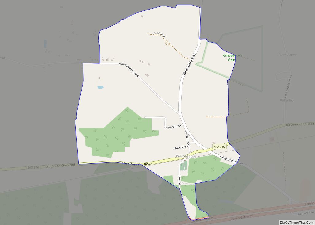
Parsonsburg is an unincorporated community and census-designated place in Wicomico County, Maryland, United States. Its population was 339 as of the 2010 census. It is part of the Salisbury, Maryland-Delaware Metropolitan Statistical Area. Parsonsburg CDP overview: Name: Parsonsburg CDP LSAD Code: 57 LSAD Description: CDP (suffix) State: Maryland County: Wicomico County Elevation: 85 ft (26 m) Total … Read more

Map of Parole CDP

Map of Parole CDP

Parole, a suburb of Annapolis, is a census-designated place (CDP) in Anne Arundel County, Maryland, United States. The population was 15,922 at the 2010 census. It is where several major roads intersect at the western edge of the state capital, Annapolis, and contains the Annapolis Mall, and a number of other large shopping centers, and … Read more

Map of Parkville CDP

Map of Parkville CDP, Maryland

Parkville is an unincorporated community and census-designated place in Baltimore County, Maryland, United States. As of the 2010 census, the population was 30,734. Parkville CDP overview: Name: Parkville CDP LSAD Code: 57 LSAD Description: CDP (suffix) State: Maryland County: Baltimore County Elevation: 331 ft (101 m) Total Area: 4.29 sq mi (11.10 km²) Land Area: 4.29 sq mi (11.10 km²) Water Area: 0.00 sq mi … Read more

Map of Peppermill Village CDP

Map of Peppermill Village CDP

Peppermill Village is an unincorporated community near Maryland Route 214 (Central Avenue) in Prince George’s County, Maryland, United States. Per the 2020 census, the population was 5,264. FedExField, Metrorail’s Blue Line, and Hampton Mall shopping center are all located nearby. Because it is not formally incorporated, it has no official boundaries, but the United States … Read more

Map of Pecktonville CDP

Map of Pecktonville CDP

Pecktonville is an unincorporated community and census-designated place in Washington County, Maryland, United States. Its population was 167 as of the 2010 census. Pecktonville CDP overview: Name: Pecktonville CDP LSAD Code: 57 LSAD Description: CDP (suffix) State: Maryland County: Washington County Elevation: 404 ft (123 m) Total Area: 0.59 sq mi (1.52 km²) Land Area: 0.59 sq mi (1.52 km²) Water Area: 0.00 sq mi … Read more

Map of Pasadena CDP, Maryland

Map of Pasadena CDP, Maryland

Pasadena is a census-designated place (CDP) in Anne Arundel County, Maryland, United States. The population was 24,287 at the 2010 census. The areas of Lake Shore, Riviera Beach and Pasadena are collectively referred to as Pasadena by residents. As all areas are governed by Anne Arundel County, there is no distinction in services such as … Read more

Map of Perryman CDP

Map of Perryman CDP

Perryman is an unincorporated community and census-designated place (CDP) in Harford County, Maryland, United States. The population was 2,342 at the 2010 census. Perryman CDP overview: Name: Perryman CDP LSAD Code: 57 LSAD Description: CDP (suffix) State: Maryland County: Harford County Elevation: 39 ft (12 m) Total Area: 5.54 sq mi (14.36 km²) Land Area: 5.48 sq mi (14.20 km²) Water Area: 0.06 sq mi … Read more

Map of Perry Hall CDP

Map of Perry Hall CDP

Perry Hall is an unincorporated community and census-designated place in Baltimore County, Maryland, United States. The population was 28,474 at the 2010 census. It is a suburb of Baltimore. Perry Hall CDP overview: Name: Perry Hall CDP LSAD Code: 57 LSAD Description: CDP (suffix) State: Maryland County: Baltimore County Elevation: 253 ft (77 m) Total Area: 6.94 sq mi … Read more

Map of Perryville town, Maryland

Map of Perryville town, Maryland

Perryville is a town in Cecil County, Maryland, United States. The population was 4,361 at the 2010 census. The town is located near an exit for Interstate 95, on the north side of the outlet of the Susquehanna River. Perryville town overview: Name: Perryville town LSAD Code: 43 LSAD Description: town (suffix) State: Maryland County: … Read more

Map of Piney Point CDP

Map of Piney Point CDP

Piney Point (also known simply as “The Point“), is an unincorporated community and census-designated place in St. Mary’s County, Maryland, United States. It is known for the Paul Hall Center for Maritime Training and Education, houses along the beach, a lighthouse, and a museum. The Piney Point post office also serves St. George Island, which … Read more

Map of Pinesburg CDP

Map of Pinesburg CDP

Pinesburg is an unincorporated community and census-designated place in Washington County, Maryland, United States. Its population was 449 as of the 2010 census. Pinesburg CDP overview: Name: Pinesburg CDP LSAD Code: 57 LSAD Description: CDP (suffix) State: Maryland County: Washington County Elevation: 505 ft (154 m) Total Area: 0.73 sq mi (1.90 km²) Land Area: 0.73 sq mi (1.90 km²) Water Area: 0.00 sq mi … Read more

Map of Pikesville CDP

Map of Pikesville CDP

Pikesville is a census-designated place (CDP) in Baltimore County, Maryland, United States. Pikesville is just northwest of the Baltimore city limits. It is the northwestern suburb closest to Baltimore. The population was 30,764 at the 2010 census. The corridor along Interstate 795, which links Pikesville, Owings Mills and Reisterstown to the Baltimore Beltway (Interstate 695), … Read more