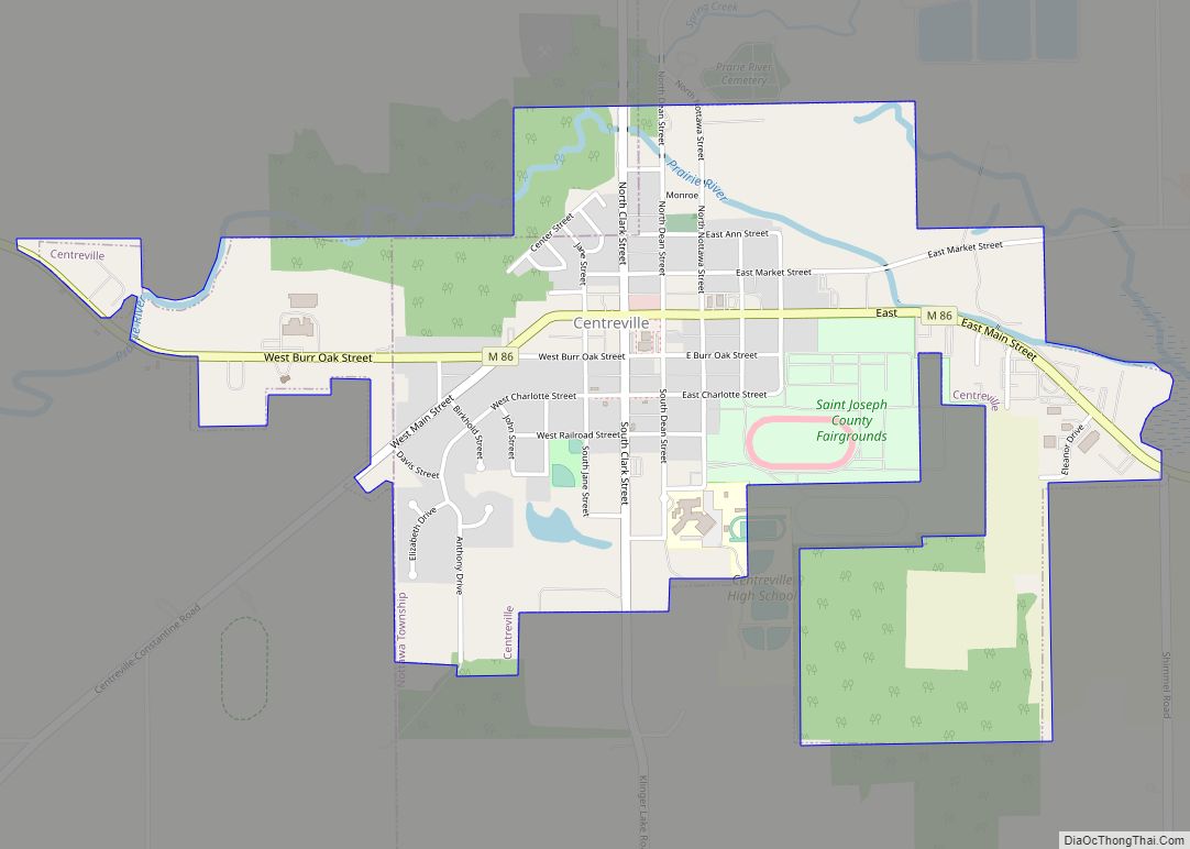
Map of Cheboygan city

Map of Cheboygan city

Cheboygan (/ʃəˈbɔɪɡən/ shə-BOY-gən) is a city in the U.S. state of Michigan. It is the county seat and largest settlement of Cheboygan County. At the 2020 census, Cheboygan had a population 4,770. Cheboygan is situated upon Lake Huron, located at the mouth of the eponymous Cheboygan River. Cheboygan is the fourth-largest American city on Lake … Read more

Map of Clarksville village, Michigan

Map of Clarksville village, Michigan

Clarksville is a village in Ionia County in the U.S. state of Michigan. As of the 2010 census, the village population was 394. The village is within Campbell Township. The Clarksville ZIP code 48815 serves the northern portion of the township as well the southern portion of Boston Township and small portions of Odessa Township … Read more

Map of Clare city, Michigan

Map of Clare city, Michigan

Clare is a city mostly in Clare County in the U.S. state of Michigan. A small portion of the city extends south into Isabella County. The population was 3,254 at the 2020 census. Clare was settled as early as 1870 and contains two listings on the National Register of Historic Places: the Clare Downtown Historic … Read more

Map of Chums Corner CDP

Map of Chums Corner CDP

Chum’s Corners (often referred to as Chums) is an unincorporated community and census-designated place (CDP) in Grand Traverse County in the U.S. state of Michigan. At the 2020 census, the population was 1,065. The community is located within Blair Township. Chums Corner CDP overview: Name: Chums Corner CDP LSAD Code: 57 LSAD Description: CDP (suffix) … Read more

Map of Chesaning village

Map of Chesaning village

Chesaning (/ˈtʃɛsənɪŋ/ CHESS-ə-ning) is a village in Saginaw County in the U.S. state of Michigan. The population was 2,394 at the 2010 census. The village is located within Chesaning Township. Chesaning village overview: Name: Chesaning village LSAD Code: 47 LSAD Description: village (suffix) State: Michigan County: Saginaw County Elevation: 640 ft (200 m) Total Area: 3.17 sq mi (8.21 km²) … Read more

Map of Chelsea city, Michigan

Map of Chelsea city, Michigan

Chelsea is a city in Washtenaw County in the U.S. state of Michigan. The population was 5,467 at the 2020 census. Chelsea city overview: Name: Chelsea city LSAD Code: 25 LSAD Description: city (suffix) State: Michigan County: Washtenaw County Incorporated: 1889 (village)2004 (city) Elevation: 932 ft (284 m) Total Area: 3.67 sq mi (9.50 km²) Land Area: 3.62 sq mi (9.37 km²) Water … Read more

Map of Clinton village, Michigan

Map of Clinton village, Michigan

Clinton is a village in Lenawee County in the Irish Hills area of the U.S. state of Michigan. The population was 2,336 at the 2010 census. The village is located within Clinton Township. Both the village and township are named in honor of DeWitt Clinton, the governor of New York from 1817 to 1828. Clinton … Read more

Map of Climax village, Michigan

Map of Climax village, Michigan

Climax is a village in Kalamazoo County in the U.S. state of Michigan. The population was 767 at the 2010 census. The village is located within Climax Township on the northern boundary with Charleston Township, and is roughly 12 miles (19 km) west of Battle Creek and 16 miles (26 km) east of Kalamazoo. Climax shares a … Read more

Map of Clifford village, Michigan

Map of Clifford village, Michigan

Clifford is a village in Lapeer County of the U.S. state of Michigan. The population was 324 at the 2010 census. The village is within Burlington Township. Clifford village overview: Name: Clifford village LSAD Code: 47 LSAD Description: village (suffix) State: Michigan County: Lapeer County Elevation: 827 ft (252 m) Total Area: 1.51 sq mi (3.91 km²) Land Area: 1.51 sq mi … Read more

Map of Clayton village, Michigan

Map of Clayton village, Michigan

Clayton is a village in Lenawee County of the U.S. state of Michigan. The population was 311 at the 2020 census. The village is located within Hudson Township to the west and Dover Township to the east. Clayton village overview: Name: Clayton village LSAD Code: 47 LSAD Description: village (suffix) State: Michigan County: Lenawee County … Read more

Map of Clawson city

Map of Clawson city, Michigan

Clawson is a city in Oakland County in the U.S. state of Michigan. It is part of the Detroit metropolitan area. At the 2010 census, its population was 11,825. Clawson city overview: Name: Clawson city LSAD Code: 25 LSAD Description: city (suffix) State: Michigan County: Oakland County Incorporated: 1921 (village)1940 (city) Elevation: 663 ft (202 m) Land … Read more

Map of Colon village

Map of Colon village, Michigan

Colon is a village in St. Joseph County in the U.S. state of Michigan. The population was 1,173 at the 2010 census. The village is located within Colon Township. Colon village overview: Name: Colon village LSAD Code: 47 LSAD Description: village (suffix) State: Michigan County: St. Joseph County Elevation: 863 ft (263 m) Total Area: 1.74 sq mi (4.50 km²) … Read more