Map of Coloma city, Michigan

Map of Coloma city, Michigan

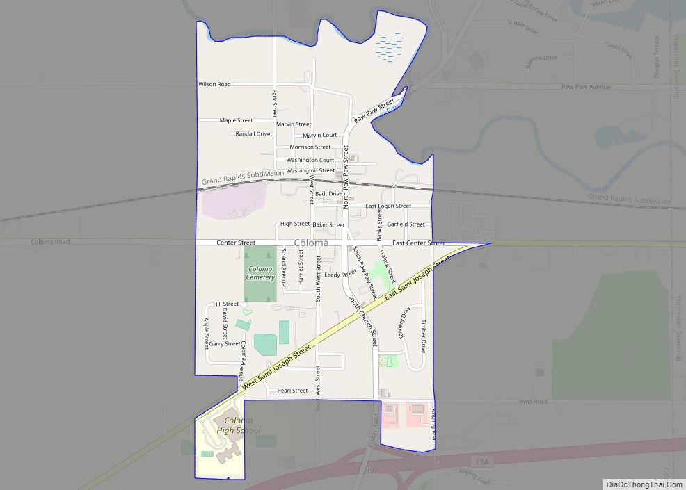
Coloma is a city in Berrien County in the U.S. state of Michigan. The population was 1,483 at the 2010 census. Coloma city overview: Name: Coloma city LSAD Code: 25 LSAD Description: city (suffix) State: Michigan County: Berrien County Elevation: 669 ft (204 m) Total Area: 0.89 sq mi (2.30 km²) Land Area: 0.89 sq mi (2.30 km²) Water Area: 0.00 sq mi (0.00 km²) Total … Read more

Map of Coleman city, Michigan

Map of Coleman city, Michigan

Coleman is a city in Midland County of the U.S. state of Michigan. The population was 1,243 at the 2010 census. Coleman city overview: Name: Coleman city LSAD Code: 25 LSAD Description: city (suffix) State: Michigan County: Midland County Incorporated: 1887 (village)1905 (city) Elevation: 758 ft (231 m) Total Area: 1.26 sq mi (3.26 km²) Land Area: 1.25 sq mi (3.23 km²) Water … Read more

Map of Coldwater city, Michigan

Map of Coldwater city, Michigan

Coldwater is a city in Branch County, Michigan, United States. As of the 2020 census, the city population was 13,822. It is the county seat of Branch County, located in the center of the southern border of Michigan. The city is surrounded by Coldwater Township, but is administratively autonomous. Coldwater city overview: Name: Coldwater city … Read more

Map of Clio city, Michigan

Map of Clio city, Michigan

Clio (/ˈklaɪoʊ/ (listen)) is a city in Genesee County in the U.S. state of Michigan. The city is located entirely within Vienna Township, but is administratively autonomous. As of the 2010 census, the city had a population of 2,646. Along with the rest of Genesee County, Clio is part of the Flint metropolitan statistical area. … Read more

Map of Concord village, Michigan

Map of Concord village, Michigan

Concord is a village in Jackson County in the U.S. state of Michigan. The population was 1,050 at the 2010 census. The village is within Concord Township. Settled in 1831, much of the village’s downtown area is designated as part of the Concord Village Historic District. The village is located along M-60 about 15 miles … Read more

Map of Comstock Park CDP

Map of Comstock Park CDP

Comstock Park is an unincorporated community and census-designated place (CDP) in Kent County in the U.S. state of Michigan. The population was 10,088 at the 2010 census. The community is located within Alpine Township to the west and Plainfield Township to the east. The community is part of the Grand Rapids metropolitan area, with the … Read more

Map of Comstock Northwest CDP

Map of Comstock Northwest CDP

Comstock Northwest is a census-designated place (CDP) in Kalamazoo County in the U.S. state of Michigan. The population was 5,455 at the 2010 census, up from 4,472 at the 2000 census. Comstock Northwest CDP overview: Name: Comstock Northwest CDP LSAD Code: 57 LSAD Description: CDP (suffix) State: Michigan County: Kalamazoo County Elevation: 870 ft (270 m) Total … Read more

Map of Columbiaville village

Map of Columbiaville village

Columbiaville is a village in Lapeer County in the U.S. state of Michigan. The population was 787 at the 2010 census. The village is within Marathon Township on the Flint River. Columbiaville village overview: Name: Columbiaville village LSAD Code: 47 LSAD Description: village (suffix) State: Michigan County: Lapeer County Elevation: 771 ft (235 m) Total Area: 1.18 sq mi … Read more

Map of Constantine village

Map of Constantine village

Constantine is a village in St. Joseph County in the U.S. state of Michigan. The population was 2,076 at the 2010 census. The village is located within Constantine Township. U.S. Highway 131 (Main Street in the village) leads to Kalamazoo to the north and to the Indiana Toll Road six miles to the south. The … Read more

Map of Copper Harbor CDP

Map of Copper Harbor CDP

Copper Harbor is an unincorporated community and census-designated place (CDP) located in Keweenaw County in the U.S. state of Michigan. It is located within Grant Township. The population of the CDP was 136 as of the 2020 census. The community is located at the northern tip of the Keweenaw Peninsula. Copper Harbor is also the … Read more

Map of Copper City village

Map of Copper City village

Copper City is a village in Houghton County of the U.S. state of Michigan. The population was 187 at the 2020 census. The village is within Calumet Township. With an area of 0.08 square miles (0.21 km), it is the second-smallest incorporated municipality by area in the state of Michigan after the nearby village of Ahmeek. … Read more

Map of Copemish village

Map of Copemish village

Copemish (/koʊpˈmɪʃ/ COPE-mish) is a village in Manistee County of the U.S. state of Michigan. The population was 195 at the 2020 census. The village is within Cleon Township. Copemish village overview: Name: Copemish village LSAD Code: 47 LSAD Description: village (suffix) State: Michigan County: Manistee County Elevation: 817 ft (249 m) Total Area: 0.98 sq mi (2.53 km²) Land … Read more