Map of Douglas city, Michigan

Map of Douglas city, Michigan

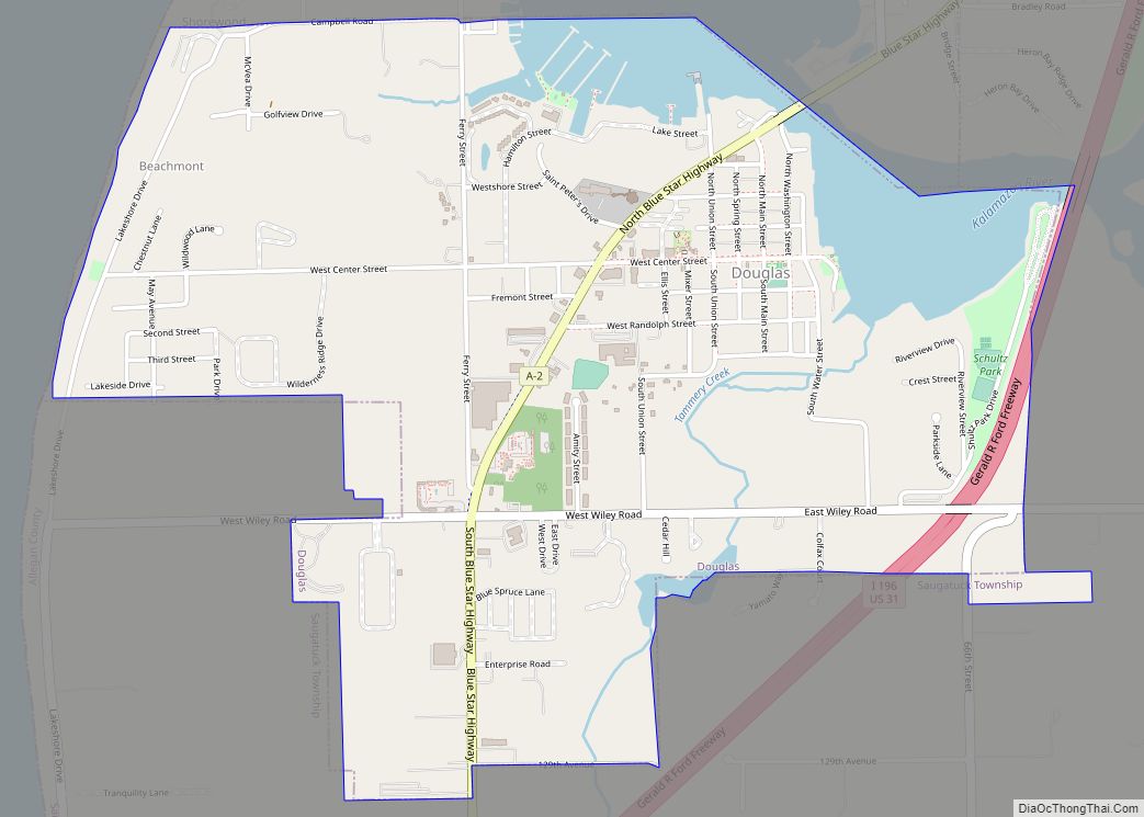
Douglas (officially known as the City of the Village of Douglas) is a city in Allegan County in the U.S. state of Michigan. The population was 1,378 at the 2020 census. The city is surrounded by Saugatuck Township and the city of Saugatuck is adjacent on the north. On December 13, 2004, residents voted to … Read more

Map of Dollar Bay CDP

Map of Dollar Bay CDP

Dollar Bay is a census-designated place (CDP) in Houghton County, Michigan, United States. The population was 1,082 at the 2010 census. Dollar Bay CDP overview: Name: Dollar Bay CDP LSAD Code: 57 LSAD Description: CDP (suffix) State: Michigan County: Houghton County Elevation: 627 ft (191 m) Total Area: 4.44 sq mi (11.51 km²) Land Area: 3.94 sq mi (10.19 km²) Water Area: 0.51 sq mi … Read more

Map of Dimondale village

Map of Dimondale village

Dimondale is a village in Eaton County in the U.S. state of Michigan. The population was 1,234 at the 2010 census. The village is located within Windsor Charter Township. Dimondale is a suburb of Lansing, which is northeast of the village in Ingham County. Dimondale village overview: Name: Dimondale village LSAD Code: 47 LSAD Description: … Read more

Map of Eagle River CDP

Map of Eagle River CDP, Michigan

Eagle River is an unincorporated community and census-designated place (CDP) in the U.S. state of Michigan. It is the county seat of Keweenaw County. Its population was 65 at the 2020 census, which makes it by far the least-populated county seat in the state of Michigan. As an unincorporated community, Eagle River has no legal … Read more

Map of Eagle Harbor CDP, Michigan

Map of Eagle Harbor CDP, Michigan

Eagle Harbor is an unincorporated community and census-designated place located on the north side of the Keweenaw Peninsula within Eagle Harbor Township, Keweenaw County in the U.S. State of Michigan. Its population was 69 as of the 2020 census. M-26 passes through this community. This hamlet was especially popular with the sailors in days past, … Read more

Map of Durand city, Michigan

Map of Durand city, Michigan

Durand is a city in Shiawassee County in the U.S. state of Michigan. The population was 3,446 at the 2010 census. Nicknamed “Railroad City, USA”, it is best known for its large train station which was a major hub for the Grand Trunk Western and Ann Arbor railroads during most of the 20th century, and … Read more

Map of Dundee village, Michigan

Map of Dundee village, Michigan

Dundee is a village in Monroe County in the U.S. state of Michigan. The population was 5,323 at the 2020 census. The village is within Dundee Township and is served by Dundee Community Schools. Settled as early as 1823, Dundee was incorporated as a village in 1855. The downtown Dundee Historic District is listed on … Read more

Map of Dryden village

Map of Dryden village, Michigan

Dryden is a village in Lapeer County in the U.S. state of Michigan. The population was 951 at the 2010 census. The village is located within Dryden Township. Dryden village overview: Name: Dryden village LSAD Code: 47 LSAD Description: village (suffix) State: Michigan County: Lapeer County Elevation: 935 ft (285 m) Total Area: 1.10 sq mi (2.85 km²) Land Area: … Read more

Map of East Jordan city

Map of East Jordan city

East Jordan is a city in Charlevoix County in the U.S. state of Michigan. The population was 2,239 at the 2020 census. The city is at the end of the south arm of Lake Charlevoix at the mouth of the Jordan River. The corporate headquarters of EJ, an international company formerly known as East Jordan … Read more

Map of East Grand Rapids city

Map of East Grand Rapids city

East Grand Rapids is a city in Kent County in the U.S. state of Michigan. As of the 2010 census, the population was 10,694. The city is part of the Grand Rapids metropolitan area and is surrounded by Grand Rapids and Grand Rapids Township, but the city is administered autonomously. East Grand Rapids city overview: … Read more

Map of Eagle village, Michigan

Map of Eagle village, Michigan

Eagle is a village in southwest Clinton County in the U.S. state of Michigan. The population was 123 at the 2010 census. The village is within Eagle Township in the southwest corner of the county. It is near Interstate 96 about 15 miles (24 km) northwest of Lansing. Eagle is the second-least populated village in the … Read more

Map of East Tawas city

Map of East Tawas city

East Tawas is a city in Iosco County in the U.S. state of Michigan. The population was 2,663 at the 2020 census. East Tawas city overview: Name: East Tawas city LSAD Code: 25 LSAD Description: city (suffix) State: Michigan County: Iosco County Incorporated: 1887 (village)1895 (city) Elevation: 584 ft (178 m) Total Area: 3.27 sq mi (8.47 km²) Land Area: … Read more