Map of Fair Plain CDP

Map of Fair Plain CDP

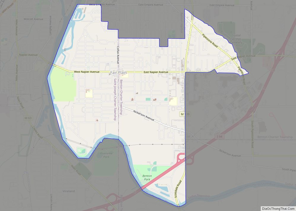
Fair Plain (also “Fairplain” ) is an unincorporated community in Berrien County in the U.S. state of Michigan. It is a census-designated place (CDP) for statistical purposes and has no legal status as a municipality. The population was 7,631 at the 2010 census. Fair Plain CDP overview: Name: Fair Plain CDP LSAD Code: 57 LSAD … Read more

Map of Evart city

Map of Evart city

Evart (/ˈɛvərt/ EHH-vərt) is a city in Osceola County in the U.S. state of Michigan. The population was 1,742 at the 2020 census. The city lies on the northern edge of Evart Township and is partially within neighboring Osceola Township, although the city is administered autonomously. Evart city overview: Name: Evart city LSAD Code: 25 … Read more

Map of Ferrysburg city

Map of Ferrysburg city

Ferrysburg is a city in Ottawa County in the U.S. state of Michigan. The population was 2,892 at the 2010 census. Spring Lake Township borders the city on the north and east, though it is administratively autonomous. The village of Spring Lake is located to the southeast, on the opposite side of Spring Lake from … Read more

Map of Ferndale city, Michigan

Map of Ferndale city, Michigan

Ferndale is a city in Oakland County in the U.S. state of Michigan. It forms part of the Detroit metropolitan area. As of the 2020 census, the city population was 19,190. Ferndale is well known in the Detroit area for its LGBT population and progressive policies. Ferndale city overview: Name: Ferndale city LSAD Code: 25 … Read more

Map of Fenton city, Michigan

Map of Fenton city, Michigan

Fenton is a city in the U.S. state of Michigan that lies mostly in Genesee County, with small portions in neighboring Oakland County and Livingston County. It is part of the Flint Metropolitan statistical area. Fenton city overview: Name: Fenton city LSAD Code: 25 LSAD Description: city (suffix) State: Michigan County: Genesee County, Livingston County, … Read more

Map of Fennville city

Map of Fennville city

Fennville is a city in Allegan County in the U.S. state of Michigan. The population was 1,745 at the 2020 census. Located on M-89 on the boundary between Manlius Township to the north and Clyde Township to the south, Fennville is located about 11 miles (18 km) southeast of the city of Saugatuck and about 13 … Read more

Map of Farwell village

Map of Farwell village, Michigan

Farwell is a village in Clare County in the U.S. state of Michigan. The population was 880 at the 2020 census. The village is located within Surrey Township about 4.0 miles (6.4 km) west of the city of Clare. Farwell village overview: Name: Farwell village LSAD Code: 47 LSAD Description: village (suffix) State: Michigan County: Clare … Read more

Map of Flushing city

Map of Flushing city, Michigan

Flushing is a city in Genesee County, Michigan, United States. The population was 8,411 at the 2020 census. Flushing is considered a suburb of Flint. It is situated within the survey area of Flushing Charter Township, but is administratively autonomous. Flushing originated as a mill town in the mid-1830s. Its location along the Flint River, … Read more

Map of Flint city

Map of Flint city

Flint city overview: Name: Flint city LSAD Code: 25 LSAD Description: city (suffix) State: Michigan County: Genesee County Incorporated: 1855 Elevation: 751 ft (229 m) Land Area: 33.44 sq mi (86.61 km²) Water Area: 0.67 sq mi (1.72 km²) Population Density: 2,429.78/sq mi (938.13/km²) Area code: 810 FIPS code: 2629000 GNISfeature ID: 0626170 Website: cityofflint.com Online Interactive Map Flint online map. Source: Basemap layers … Read more

Map of Flat Rock city, Michigan

Map of Flat Rock city, Michigan

Flat Rock is a city primarily in Wayne County, Michigan, United States, with a small portion of the city extending into Monroe County. At the 2020 census, the population was 10,541. Flat Rock city overview: Name: Flat Rock city LSAD Code: 25 LSAD Description: city (suffix) State: Michigan County: Monroe County, Wayne County Incorporated: 1923 … Read more

Map of Filer City CDP

Map of Filer City CDP

Filer City is an unincorporated community and census-designated place in Filer Charter Township, Manistee County, Michigan, United States. Its population was 116 as of the 2010 census. The community is located on Manistee Lake just south of Manistee. Filer City has a post office with ZIP code 49634. The post office opened March 10, 1868, … Read more

Map of Fife Lake village

Map of Fife Lake village

Fife Lake (/faɪf/ FYFE) is a village in southeastern Grand Traverse County in the U.S. state of Michigan. Its population was 456 at the 2020 census, up from 443 at the 2010 census. The village is part of the Traverse City micropolitan area, and lies upon the shore of the lake of the same name. … Read more