Map of Rockford city, Michigan

Map of Rockford city, Michigan

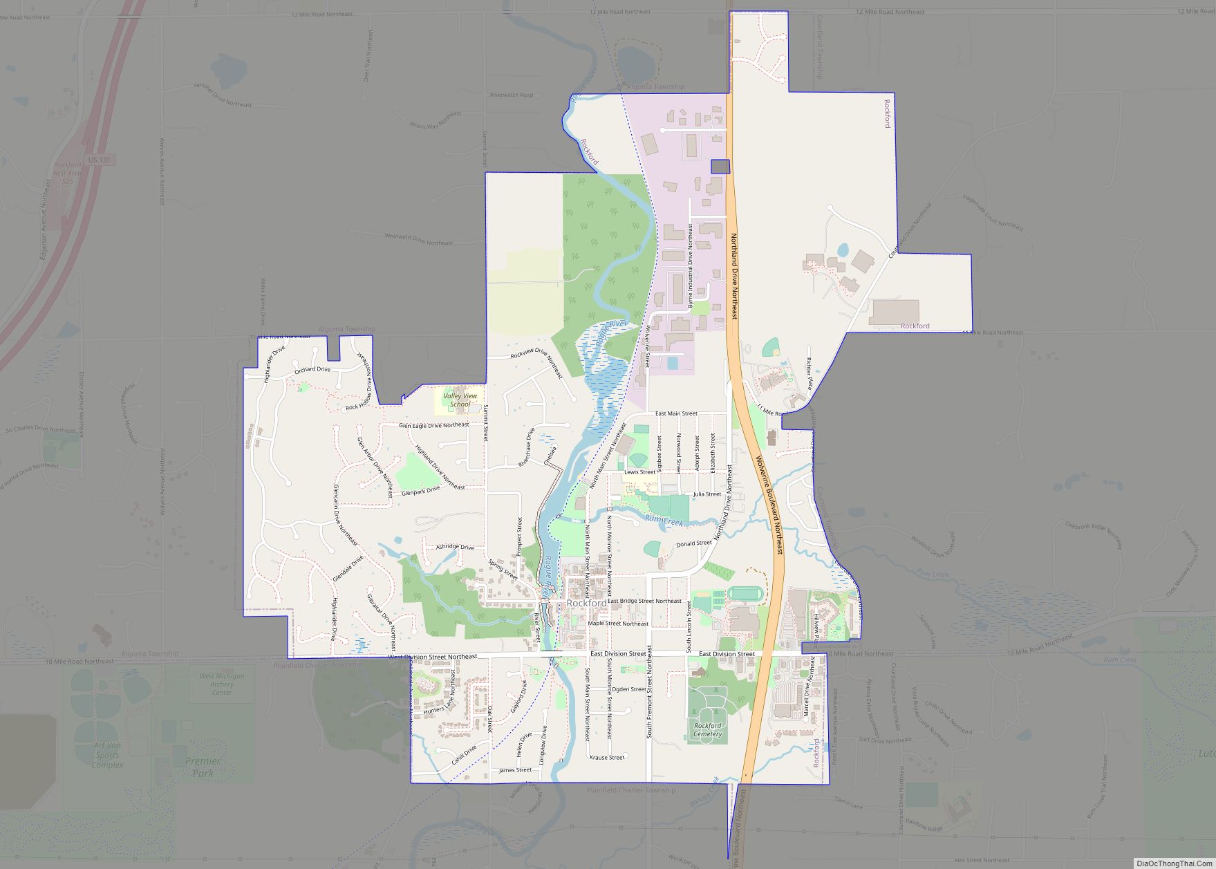
Rockford is a city in Kent County in the U.S. state of Michigan. The population was 5,719 at the 2010 census. Located along the Rogue River, the city is part of the Grand Rapids metropolitan area and is about 10 miles (16.1 km) north of the city of Grand Rapids. Rockford city overview: Name: Rockford city … Read more

Map of Roseville city, Michigan

Map of Roseville city, Michigan

Roseville is a city in Macomb County in the U.S. state of Michigan, and is a part of the Metro Detroit area. The population was 47,299 at the 2010 census. Until 1958, Roseville was a part of Erin Township. Roseville city overview: Name: Roseville city LSAD Code: 25 LSAD Description: city (suffix) State: Michigan County: … Read more

Map of Rosebush village

Map of Rosebush village

Rosebush is a village in Isabella County in the U.S. state of Michigan. The population was 368 at the 2010 census. The village is within Isabella Township. Rosebush village overview: Name: Rosebush village LSAD Code: 47 LSAD Description: village (suffix) State: Michigan County: Isabella County Elevation: 781 ft (238 m) Total Area: 0.89 sq mi (2.31 km²) Land Area: 0.89 sq mi … Read more

Map of Rose City city

Map of Rose City, Michigan

Rose City is a city in Ogemaw County in the U.S. state of Michigan. The population was 653 at the 2010 census, which ranks it as the seventh-smallest city by population in the state. Rose City overview: Name: Rose City LSAD Code: 25 LSAD Description: city (suffix) State: Michigan County: Ogemaw County Incorporated: 1910 Elevation: … Read more

Map of Roscommon village

Map of Roscommon village

Roscommon (/rɒsˈkɒmən/ RAHS-kah-men) is a village in Roscommon County the U.S. state of Michigan. The population was 981 at the 2020 census. Roscommon is the county seat of Roscommon County. Roscommon village overview: Name: Roscommon village LSAD Code: 47 LSAD Description: village (suffix) State: Michigan County: Roscommon County Incorporated: 1882 Elevation: 1,135 ft (346 m) Total Area: … Read more

Map of Roosevelt Park city

Map of Roosevelt Park city

Roosevelt Park is a city in Muskegon County in the U.S. state of Michigan. The population was 3,831 at the 2010 census. Roosevelt Park city overview: Name: Roosevelt Park city LSAD Code: 25 LSAD Description: city (suffix) State: Michigan County: Muskegon County Elevation: 620 ft (189 m) Total Area: 1.03 sq mi (2.66 km²) Land Area: 1.03 sq mi (2.66 km²) Water Area: … Read more

Map of Sand Lake CDP

Map of Sand Lake CDP

Sand Lake is an unincorporated community and census-designated place (CDP) in Iosco County in the U.S. state of Michigan. The CDP had a population of 1,412 at the 2010 census. The CDP occupies portions of Grant Township, Plainfield Township, and Wilber Township. Sand Lake CDP overview: Name: Sand Lake CDP LSAD Code: 57 LSAD Description: … Read more

Map of Saline city, Michigan

Map of Saline city, Michigan

Saline (/səˈliːn/ suh-LEEN) is a city in Washtenaw County in the U.S. state of Michigan. The population was 8,948 at the 2020 census. The city borders Saline Township to the southwest, and the two are administered autonomously. Saline city overview: Name: Saline city LSAD Code: 25 LSAD Description: city (suffix) State: Michigan County: Washtenaw County … Read more

Map of Saginaw city

Map of Saginaw city, Michigan

Saginaw (/ˈsæɡɪnɔː/) is a city in the U.S. state of Michigan and the seat of Saginaw County. The city of Saginaw and Saginaw County are both in the area known as Mid-Michigan. Saginaw is adjacent to Saginaw Charter Township and considered part of Greater Tri-Cities region of Central Michigan. The Saginaw County MSA had a … Read more

Map of Royal Oak city

Map of Royal Oak city

Royal Oak is a city in Oakland County in the U.S. state of Michigan. An inner-ring suburb of Detroit, Royal Oak is about 3 miles (4.8 km) north of Detroit’s city limits. As of the 2020 census, the city had a population of 58,211. Royal Oak is located along the Woodward Corridor, and is served by … Read more

Map of Rothbury village

Map of Rothbury village

Rothbury is a village in Grant Township, Oceana County in the U.S. state of Michigan. The population was 486 at the 2010 census. Rothbury village overview: Name: Rothbury village LSAD Code: 47 LSAD Description: village (suffix) State: Michigan County: Oceana County Elevation: 702 ft (214 m) Total Area: 3.42 sq mi (6.65 km²) Land Area: 2.50 sq mi (6.37 km²) Water Area: 0.92 sq mi … Read more

Map of Sandusky city

Map of Sandusky city, Michigan

Sandusky is a city in the U.S. state of Michigan. The population was 2,679 at the 2010 census. It is the county seat of Sanilac County. Sandusky city overview: Name: Sandusky city LSAD Code: 25 LSAD Description: city (suffix) State: Michigan County: Sanilac County Elevation: 771 ft (235 m) Total Area: 2.15 sq mi (5.57 km²) Land Area: 2.15 sq mi (5.56 km²) … Read more