Map of Saugatuck city

Map of Saugatuck city

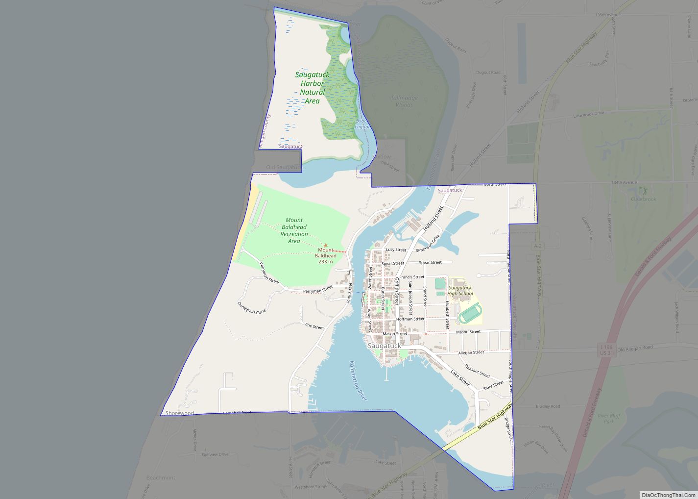
Saugatuck is a city in Allegan County in the U.S. state of Michigan. The population was 865 at the 2020 census. The city is within Saugatuck Township, but is administratively autonomous. Originally a lumber town and port, Saugatuck, along with the adjacent city of Douglas, became a noted art colony and tourist destination in the … Read more

Map of Saranac village

Map of Saranac village

Saranac is a village in Boston Twp, Ionia County in the U.S. state of Michigan. The population was 1,325 at the 2010 census. Today, Saranac serves as a retail and services hub for agricultural areas surrounding the village. Saranac village overview: Name: Saranac village LSAD Code: 47 LSAD Description: village (suffix) State: Michigan County: Ionia … Read more

Map of Sanford village, Michigan

Map of Sanford village, Michigan

Sanford is a village in Midland County in the U.S. state of Michigan. The population was 859 at the 2010 census. The village is located within Jerome Township. Sanford village overview: Name: Sanford village LSAD Code: 47 LSAD Description: village (suffix) State: Michigan County: Midland County Elevation: 630 ft (192 m) Total Area: 1.55 sq mi (4.01 km²) Land Area: … Read more

Map of Sandusky city

Map of Sandusky city, Michigan

Sandusky is a city in the U.S. state of Michigan. The population was 2,679 at the 2010 census. It is the county seat of Sanilac County. Sandusky city overview: Name: Sandusky city LSAD Code: 25 LSAD Description: city (suffix) State: Michigan County: Sanilac County Elevation: 771 ft (235 m) Total Area: 2.15 sq mi (5.57 km²) Land Area: 2.15 sq mi (5.56 km²) … Read more

Map of Shepherd village

Map of Shepherd village, Michigan

Shepherd (/ʃɛpˈʌrd/ shep-urd) is a village in Isabella County in the U.S. state of Michigan. The population was 1,469 at the 2020 census. The village is located within Coe Township. Shepherd village overview: Name: Shepherd village LSAD Code: 47 LSAD Description: village (suffix) State: Michigan County: Isabella County Incorporated: 1889 Elevation: 774 ft (236 m) Total Area: … Read more

Map of Shelby village, Michigan

Map of Shelby village, Michigan

Shelby is a village in Oceana County in the U.S. state of Michigan. The population was 2,065 at the 2010 census. Shelby village overview: Name: Shelby village LSAD Code: 47 LSAD Description: village (suffix) State: Michigan County: Oceana County Elevation: 817 ft (249 m) Total Area: 1.64 sq mi (4.25 km²) Land Area: 1.64 sq mi (4.25 km²) Water Area: 0.00 sq mi (0.00 km²) Total … Read more

Map of Sebewaing village

Map of Sebewaing village

Sebewaing is a village in Huron County in the U.S. state of Michigan. The population was 1,721 at the 2020 census. The village is within Sebewaing Township. This community is known as the Sugar Beet Capital, due to the Michigan Sugar slicing mill located within the village and the yearly Michigan Sugar Festival. The Sebewaing … Read more

Map of Scottville city, Michigan

Map of Scottville city, Michigan

Scottville is a city in Mason County in the U.S. state of Michigan. The population was 1,214 at the 2010 census. Scottville city overview: Name: Scottville city LSAD Code: 25 LSAD Description: city (suffix) State: Michigan County: Mason County Founded: 1874 Incorporated: 1889 (village)1907 (city) Elevation: 692 ft (211 m) Total Area: 1.49 sq mi (3.86 km²) Land Area: 1.49 sq mi … Read more

Map of Schoolcraft village

Map of Schoolcraft village

Schoolcraft is a village in Kalamazoo County, Michigan, United States. The village is located in Schoolcraft Township approximately 13 miles (21 km) south of Kalamazoo on U.S. Route 131. The population was 1,525 at the 2010 census. The village is named in honor of geographer, geologist, and ethnologist Henry Schoolcraft. Schoolcraft village overview: Name: Schoolcraft village … Read more

Map of Sherwood village, Michigan

Map of Sherwood village, Michigan

Sherwood is a village in Branch County of the U.S. state of Michigan. The population was 309 at the 2010 census. The village is in Sherwood Township near the St. Joseph River. Sherwood village overview: Name: Sherwood village LSAD Code: 47 LSAD Description: village (suffix) State: Michigan County: Branch County Elevation: 879 ft (268 m) Total Area: … Read more

Map of Sheridan village, Michigan

Map of Sheridan village, Michigan

Sheridan is a village in Montcalm County in the U.S. state of Michigan. The population was 649 at the 2010 census. The village is located at the corners of four townships and incorporates land from each: Evergreen Township to the northeast, Bushnell Township to the southeast, Fairplain Township to the southwest, and Sidney Township to … Read more

Map of Shorewood-Tower Hills-Harbert CDP

Map of Shorewood-Tower Hills-Harbert CDP

Shorewood-Tower Hills-Harbert CDP overview: Name: Shorewood-Tower Hills-Harbert CDP LSAD Code: 57 LSAD Description: CDP (suffix) State: Michigan County: Berrien County FIPS code: 2673730 Online Interactive Map Shorewood-Tower Hills-Harbert online map. Source: Basemap layers from Google Map, Open Street Map (OSM), Arcgisonline, Wmflabs. Boundary Data from Database of Global Administrative Areas. Shorewood-Tower Hills-Harbert location map. Where … Read more