Map of Spring Valley CDP, Nevada
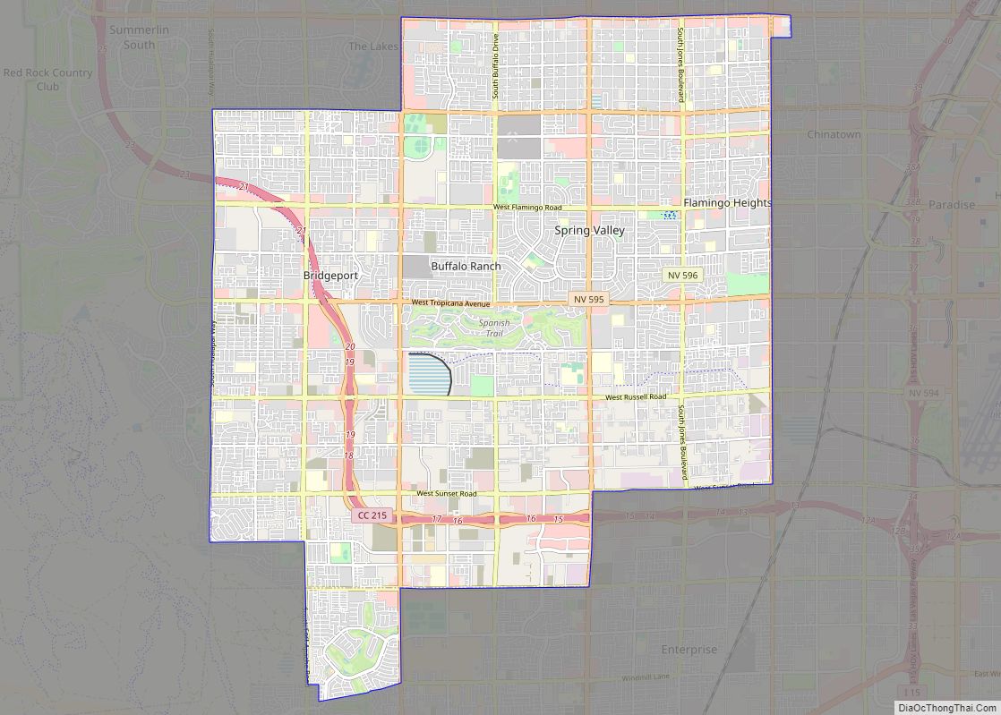
Spring Valley is an unincorporated town and census-designated place in Clark County, Nevada, United States, located 2 miles (3 km) west of the Las Vegas Strip. The population was 215,597 at the 2020 census. Spring Valley was formed in May 1981. Spring Valley CDP overview: Name: Spring Valley CDP LSAD Code: 57 LSAD Description: CDP (suffix) ... Read more
Map of Spring Valley CDP, Nevada
Map of Spring Creek CDP, Nevada
Spring Creek is a census-designated place (CDP) in central Elko County, in northeastern Nevada in the western United States. It mainly serves as a bedroom community for the businesses and industries in and around the nearby city of Elko. It is part of the Elko Micropolitan Statistical Area. The population was 12,361 at the 2010 ... Read more
Map of Spring Creek CDP, Nevada
Map of Spanish Springs CDP
Spanish Springs is a census-designated place (CDP) in Washoe County, Nevada, United States. It is located in the northeastern part of the Reno–Sparks Metropolitan Statistical Area. The population was 15,064 at the 2010 Census. Spanish Springs CDP overview: Name: Spanish Springs CDP LSAD Code: 57 LSAD Description: CDP (suffix) State: Nevada County: Washoe County Elevation: ... Read more
Map of Spanish Springs CDP
Map of Smith Valley CDP
Smith Valley is a census-designated place (CDP) in Lyon County, Nevada, United States. The population was 1,603 at the 2010 census. Smith Valley CDP overview: Name: Smith Valley CDP LSAD Code: 57 LSAD Description: CDP (suffix) State: Nevada County: Lyon County Elevation: 4,731 ft (1,442 m) Total Area: 103.88 sq mi (269.06 km²) Land Area: 101.96 sq mi (264.07 km²) Water Area: 1.92 sq mi ... Read more
Map of Smith Valley CDP
Map of Skyland CDP
Skyland is a census-designated place (CDP) in Douglas County, Nevada, United States. The population was 376 at the 2010 census. Skyland CDP overview: Name: Skyland CDP LSAD Code: 57 LSAD Description: CDP (suffix) State: Nevada County: Douglas County Elevation: 6,260 ft (1,910 m) Total Area: 4.46 sq mi (11.54 km²) Land Area: 4.36 sq mi (11.28 km²) Water Area: 0.10 sq mi (0.26 km²) Total Population: ... Read more
Map of Skyland CDP
Map of Silver Springs CDP, Nevada
Silver Springs is a census-designated place (CDP) in Lyon County, Nevada, United States at the intersection of US 50 (California Trail) and US 95A. The population was 5,296 at the 2010 census. Lahontan Reservoir, Lahontan State Recreation Area and historic Fort Churchill State Historic Park are all located nearby. The area is served by the ... Read more
Map of Silver Springs CDP, Nevada
Map of Silver Peak CDP
Silver Peak (also Silverpeak) is an unincorporated community and census-designated place (CDP) in Esmeralda County, Nevada, United States. It lies along State Route 265, 20 miles (32 km) south of U.S. Route 6 and 30 miles (48 km) west of Goldfield, the county seat of Esmeralda County. It has a post office, with the ZIP code of ... Read more
Map of Silver Peak CDP
Map of Silver City CDP, Nevada
Silver City is a Census Designated Place and small residential community in Lyon County, Nevada, USA, near the Lyon/Carson border. The population as of the 2000 census was 170. Silver City CDP overview: Name: Silver City CDP LSAD Code: 57 LSAD Description: CDP (suffix) State: Nevada County: Lyon County Elevation: 5,102 ft (1,555 m) Total Area: 0.97 sq mi ... Read more
Map of Silver City CDP, Nevada
Map of Searchlight CDP
Searchlight is an unincorporated town and census-designated place (CDP) in Clark County, Nevada, United States, at the topographic saddle between two mountain ranges. At the 2020 census it had a population of 445. Searchlight CDP overview: Name: Searchlight CDP LSAD Code: 57 LSAD Description: CDP (suffix) State: Nevada County: Clark County Founded: May 6, 1897; 126 ... Read more
Map of Searchlight CDP
Map of Schurz CDP
Schurz is a census-designated place (CDP) in Mineral County, Nevada, United States. The population was 658 at the 2010 census. It is located on the Walker River Indian Reservation. It is the burial place of Wovoka, the Paiute messiah who originated the Ghost Dance movement. Schurz CDP overview: Name: Schurz CDP LSAD Code: 57 LSAD ... Read more
Map of Schurz CDP
Map of Summerlin South CDP
Summerlin South, also seen on maps as South Summerlin, is a census-designated place (CDP) in Clark County, Nevada, United States, on the western edge of the Las Vegas Valley and adjacent to the Red Rock Canyon National Conservation Area. It is so named because it is a southward extension of the master-planned community of Summerlin. ... Read more
Map of Summerlin South CDP
Map of Stateline CDP
Stateline is a census-designated place (CDP) on the southeastern shore of Lake Tahoe in Douglas County, Nevada, United States. It lies next to the California state line and City of South Lake Tahoe. The population was 842 at the 2010 census. The population swells considerably during the busy winter and summer seasons, due to the ... Read more
Map of Stateline CDP