Map of Ho-Ho-Kus borough

Map of Ho-Ho-Kus borough

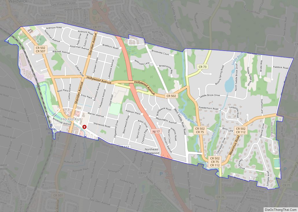
Ho-Ho-Kus (/hoʊˈhoʊkəs/) is a borough in Bergen County, in the U.S. state of New Jersey. As of the 2020 United States census, the borough’s population was 4,258, an increase of 180 (+4.4%) from the 2010 census count of 4,078, which in turn reflected an increase of 18 (+0.4%) from the 4,060 counted in the 2000 … Read more

Map of Hillsdale borough, New Jersey

Map of Hillsdale borough, New Jersey

Hillsdale is a borough in the northern portion of Bergen County, in the U.S. state of New Jersey, within the New York City metropolitan area. As of the 2020 United States census, the borough’s population was 10,143, a decrease of 76 (−0.7%) from the 2010 census count of 10,219, which in turn reflected an increase … Read more

Map of Hightstown borough

Map of Hightstown borough

Hightstown is a borough in Mercer County, in the U.S. state of New Jersey. As of the 2020 United States census, the borough’s population was 5,900, an increase of 406 (+7.4%) from the 2010 census count of 5,494, which in turn reflected an increase of 278 (+5.3%) from the 5,216 counted in the 2000 census. … Read more

Map of Highlands borough, New Jersey

Map of Highlands borough, New Jersey

Highlands is a borough in northern Monmouth County, in the U.S. state of New Jersey. An historic waterfront community located on the Raritan Bay within the Raritan Valley region, this scenic borough is a commuter town of New York City in the New York metropolitan area. As of the 2020 United States census, the borough’s … Read more

Map of Hope CDP, New Jersey

Map of Hope CDP, New Jersey

Hope is an unincorporated community and census-designated place (CDP) located within Hope Township in Warren County, New Jersey, United States, that was defined as part of the 2010 United States Census. As of the 2010 Census, the CDP’s population was 195. Hope CDP overview: Name: Hope CDP LSAD Code: 57 LSAD Description: CDP (suffix) State: … Read more

Map of Hopatcong borough

Map of Hopatcong borough

Hopatcong (/hoʊˈpætkɒŋ/ hoh-PAT-kong) is a borough in Sussex County, in the U.S. state of New Jersey. As of the 2020 United States census, the borough’s population was 14,362, a decrease of 785 (−5.2%) from the 2010 census count of 15,147, which in turn reflected a decline of 741 (−4.7%) from the 15,888 counted in the … Read more

Map of Holiday Heights CDP

Map of Holiday Heights CDP

Holiday Heights is an unincorporated community and census-designated place (CDP) located within Berkeley Township, in Ocean County, New Jersey, United States. As of the 2010 United States Census, the CDP’s population was 2,099. Holiday Heights CDP overview: Name: Holiday Heights CDP LSAD Code: 57 LSAD Description: CDP (suffix) State: New Jersey County: Ocean County Elevation: … Read more

Map of Holiday City South CDP

Map of Holiday City South CDP

Holiday City South is an unincorporated community and census-designated place (CDP) located within Berkeley Township, in Ocean County, New Jersey, United States. As of the 2010 United States Census, the CDP’s population was 3,689. Holiday City South CDP overview: Name: Holiday City South CDP LSAD Code: 57 LSAD Description: CDP (suffix) State: New Jersey County: … Read more

Map of Holiday City-Berkeley CDP

Map of Holiday City-Berkeley CDP

Holiday City-Berkeley is an unincorporated community and census-designated place (CDP) located within Berkeley Township, in Ocean County, New Jersey, United States. As of the 2010 United States Census, the CDP’s population was 13,884. Holiday City-Berkeley is a retirement community where residents must be over the age of 55 to own property and participate in community … Read more

Map of Hoboken city, New Jersey

Map of Hoboken city, New Jersey

Hoboken city overview: Name: Hoboken city LSAD Code: 25 LSAD Description: city (suffix) State: New Jersey County: Hudson County Incorporated: April 9, 1849 Elevation: 23 ft (7 m) Total Area: 1.97 sq mi (5.10 km²) Land Area: 1.25 sq mi (3.24 km²) Water Area: 0.72 sq mi (1.87 km²)  37.50% Total Population: 60,419 Population Density: 48,335.2/sq mi (18,662.3/km²) ZIP code: 07030 Area code: 201 FIPS code: 3432250 … Read more

Map of Kearny town, New Jersey

Map of Kearny town, New Jersey

Kearny (/ˈkɑːrni/ KAR-nee) is a town in the western part of Hudson County, in the U.S. state of New Jersey, and a suburb of Newark. As of the 2020 United States census, the town’s population was 41,999, an increase of 1,315 (+3.2%) from the 2010 census count of 40,684, which in turn reflected an increase … Read more

Map of Keansburg borough

Map of Keansburg borough

Keansburg (/ˈkiːnzbɜːrɡ/ KEENZ-burg) is a borough in Monmouth County, in the U.S. state of New Jersey. As of the 2020 United States census, the borough’s population was 9,755, a decrease of 350 (−3.5%) from the 2010 census count of 10,105, which in turn reflected a decline of 627 (−5.8%) from 10,732 in the 2000 Census. … Read more