Map of Saddle River borough

Map of Saddle River borough

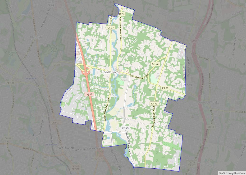
Saddle River is a borough in Bergen County, in the U.S. state of New Jersey. It is a suburb of New York City, located just over 25 miles (40 km) northwest of Manhattan. The town is known for its natural fields, farmland, forests, and rivers, and has a bucolic atmosphere, due in part to a minimum … Read more

Map of Rutherford borough, New Jersey

Map of Rutherford borough, New Jersey

Rutherford is a borough in Bergen County, in the U.S. state of New Jersey. As of the 2020 United States census, the borough’s population was 18,834, an increase of 773 (+4.3%) from the 2010 census count of 18,061, which in turn reflected a decline of 49 (−0.3%) from the 18,110 counted in the 2000 census. … Read more

Map of Runnemede borough

Map of Runnemede borough

Runnemede is a borough in Camden County, in the U.S. state of New Jersey. As of the 2020 United States census, the borough’s population was 8,324, a decrease of 144 (−1.7%) from the 2010 census count of 8,468, which in turn reflected a decline of 65 (−0.8%) from the 8,533 counted in the 2000 census. … Read more

Map of Rumson borough

Map of Rumson borough

Rumson is a borough in Monmouth County, in the U.S. state of New Jersey, and is part of the New York Metropolitan Area. As of the 2020 United States census, the borough’s population was 7,343, an increase of 221 (+3.1%) from the 2010 census count of 7,122, which in turn reflected a decline of 15 … Read more

Map of Sewaren CDP

Map of Sewaren CDP

Sewaren (pronounced SEE-waren) is an unincorporated community and census-designated place (CDP) within Woodbridge Township, in Middlesex County, New Jersey, United States. As of the 2010 United States Census, the CDP’s population was 2,756. PSE&G’s Sewaren Generating Station is a 538 megawatt facility on 152 acres (62 ha) along the Arthur Kill. The facility had five steam … Read more

Map of Secaucus town

Map of Secaucus town

Secaucus (/ˈsiːkɔːkəs/ SEE-kaw-kəs) is a town in Hudson County, in the U.S. state of New Jersey. As of the 2020 United States census, the town’s population was 22,181, an increase of 5,917 (+36.4%) from the 2010 census count of 16,264, which in turn reflected an increase of 333 (+2.1%) from the 15,931 counted in the … Read more

Map of Seaside Park borough

Map of Seaside Park borough

Seaside Park is a borough in Ocean County, in the U.S. state of New Jersey. It is part of the Ocean City metropolitan statistical area. As of the 2020 United States census, the borough’s population was 1,436, a decrease of 143 (−9.1%) from the 2010 census count of 1,579, which in turn had reflected decline … Read more

Map of Seaside Heights borough

Map of Seaside Heights borough

Seaside Heights is a borough situated on the Jersey Shore, within Ocean County, in the U.S. state of New Jersey. As of the 2020 United States census, the borough’s population was 2,440, a decrease of 447 (−15.5%) from the 2010 census count of 2,887, which in turn had reflected a decline of 268 (−8.5%) from … Read more

Map of Silver Lake CDP, New Jersey

Map of Silver Lake CDP, New Jersey

Silver Lake is an unincorporated community and census-designated place (CDP) in Essex County, New Jersey, United States, that is split between Belleville (with 3,769 of the CDP’s residents) and Bloomfield (474 of the total). As of the 2010 United States Census, the CDP’s total population was 4,243. Silver Lake CDP overview: Name: Silver Lake CDP … Read more

Map of Shrewsbury borough, New Jersey

Map of Shrewsbury borough, New Jersey

Shrewsbury borough overview: Name: Shrewsbury borough LSAD Code: 21 LSAD Description: borough (suffix) State: New Jersey County: Monmouth County FIPS code: 3467350 Online Interactive Map Shrewsbury online map. Source: Basemap layers from Google Map, Open Street Map (OSM), Arcgisonline, Wmflabs. Boundary Data from Database of Global Administrative Areas. Shrewsbury location map. Where is Shrewsbury borough? … Read more

Map of Short Hills CDP

Map of Short Hills CDP

Short Hills is an unincorporated community located within Millburn Township, in Essex County, in the U.S. state of New Jersey. It is a commuter town for residents who work in New York City. As of the 2020 U.S. census, Short Hills’ population was 14,422. For statistical purposes, the United States Census Bureau has defined Short … Read more

Map of Ship Bottom borough

Map of Ship Bottom borough

Ship Bottom is a borough in Ocean County, in the U.S. state of New Jersey. As of the 2020 United States census, the borough’s population was 1,098, a decrease of 58 (−5.0%) from the 2010 census count of 1,156, which in turn reflected a decline of 228 (−16.5%) from the 1,384 counted in the 2000 … Read more