Rutherford is a borough in Bergen County, in the U.S. state of New Jersey. As of the 2020 United States census, the borough’s population was 18,834, an increase of 773 (+4.3%) from the 2010 census count of 18,061, which in turn reflected a decline of 49 (−0.3%) from the 18,110 counted in the 2000 census.
Rutherford was formed as a borough by an act of the New Jersey Legislature on September 21, 1881, from portions of Union Township, based on the results of a referendum held on the previous day. The borough was named for John Rutherfurd, a U.S. Senator who owned land in the area.
Rutherford has been called the “Borough of Trees” and “The First Borough of Bergen County”, and is known as well for its pedestrian-focused downtown area adjacent to the borough’s Bergen Line (New Jersey Transit) railway station.
| Name: | Rutherford borough |
|---|---|
| LSAD Code: | 21 |
| LSAD Description: | borough (suffix) |
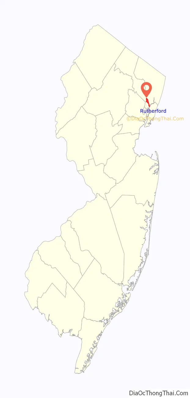
| State: | New Jersey |
| County: | Bergen County |
| Incorporated: | September 21, 1881 |
| Elevation: | 66 ft (20 m) |
| Total Area: | 2.89 sq mi (7.49 km²) |
| Land Area: | 2.78 sq mi (7.20 km²) |
| Water Area: | 0.11 sq mi (0.29 km²) 3.88% |
| Total Population: | 18,834 |
| Population Density: | 6,772.4/sq mi (2,614.8/km²) |
| ZIP code: | 07070 |
| Area code: | 201 |
| FIPS code: | 3465280 |
| GNISfeature ID: | 0885383 |
| Website: | www.rutherfordboronj.com |
Online Interactive Map
Click on ![]() to view map in "full screen" mode.
to view map in "full screen" mode.
Rutherford location map. Where is Rutherford borough?

History
The ridge above the New Jersey Meadowlands upon which Rutherford sits was settled by Lenape Native Americans long before the arrival of Walling Van Winkle in 1687. Union Avenue, which runs from the Meadowlands to the Passaic River, may have been an Indian trail, but was more likely a property boundary line; it was referenced in the 1668 grant of land by proprietary Governor Philip Carteret to John Berry.
During the early days of settlement, the land that is now Rutherford was part of New Barbadoes Township, as Berry had lived in Barbados, another English colony, before claiming his grant in New Jersey. New Barbadoes was part of Essex County from 1693 to 1710, when Bergen County was formed. In 1826, the land became part of Lodi Township (of which today’s remaining portion is now South Hackensack). When Hudson County was formed in 1840, the area that is today North Arlington, Lyndhurst, Rutherford and East Rutherford became part of Harrison Township (of which today’s remaining portion is Harrison town). However, the area reverted to Bergen County in 1852 and became known as Union Township.
Part of the region was known as Boiling Springs for a powerful and ceaseless spring located in the vicinity. Despite its name, the spring actually consisted of cold groundwater seeps rather than hot springs.
The Erie Railroad built its Main Line from Jersey City across the Meadowlands in the 1840s. Daniel Van Winkle, a descendant of Walling, donated land in 1866 for a train station at Boiling Springs. Several resorts were built along the Passaic, with guests disembarking at Boiling Springs station and taking Union Avenue to the river. Later, the railroad opened a station closer to the river, at Carlton Hill, and a horsecar line (briefly on rails) along Jackson Ave took travelers to the resort area.
At the time, much of the property in Rutherford was farmland owned by the estate of John Rutherfurd, a former New Jersey legislator and U.S. Senator, whose homestead was along the Passaic River, near present-day Rutherford Avenue. Van Winkle opened a real estate office at Depot Square (now Station Square) to sell the land of the Rutherfurd Park Association, and began to lay out the area’s street grid. The main roads were Orient Way, a wide boulevard heading south-southwest from Station Square, and Park Avenue, which headed west-southwest from Station Square to bring traffic to the new Valley Brook Race Course in what is now Lyndhurst.
In the 1870s, the area began to be called “Rutherford”. The definitive reason for the change in spelling of the final syllable from “furd” to “ford” is unknown, though the change may have been the result of name recognition of the Ohio politician Rutherford B. Hayes, who was elected President in 1876, or could have been because of a clerical error by the United States Postal Service. The Post Office opened a facility called “Rutherford” in 1876. On September 21, 1881, the Borough of Rutherford was formed by formal vote of secession from Union Township. By then, the community had about 1,000 residents.
Historic sites
Rutherford is home to the following locations on the National Register of Historic Places:
- Iviswold – 223 Montross Avenue (added 2004). Located on the campus of Felician College, a $9 million renovation project of the Iviswold castle that took 14 years was completed in 2013. Originally constructed by Floyd W. Tomkins in 1869, the house was expanded to three levels, 25 rooms and 18,000 square feet (1,700 m) by textbook publisher David Brinkerhoff Iverson after he acquired the home in 1887, based on a design by architect William H. Miller.
- Kip Homestead – 12 Meadow Road (added 1983).
- Rutherford station – Station Square (added 1984). New Jersey Transit initiated a $1 million project in 2009 to renovate the station, which had been constructed in 1898, to restore the interior of the structure.
- William Carlos Williams House – 9 Ridge Road (added 1973).
- Yereance-Berry House – 91 Crane Avenue (added 1983).
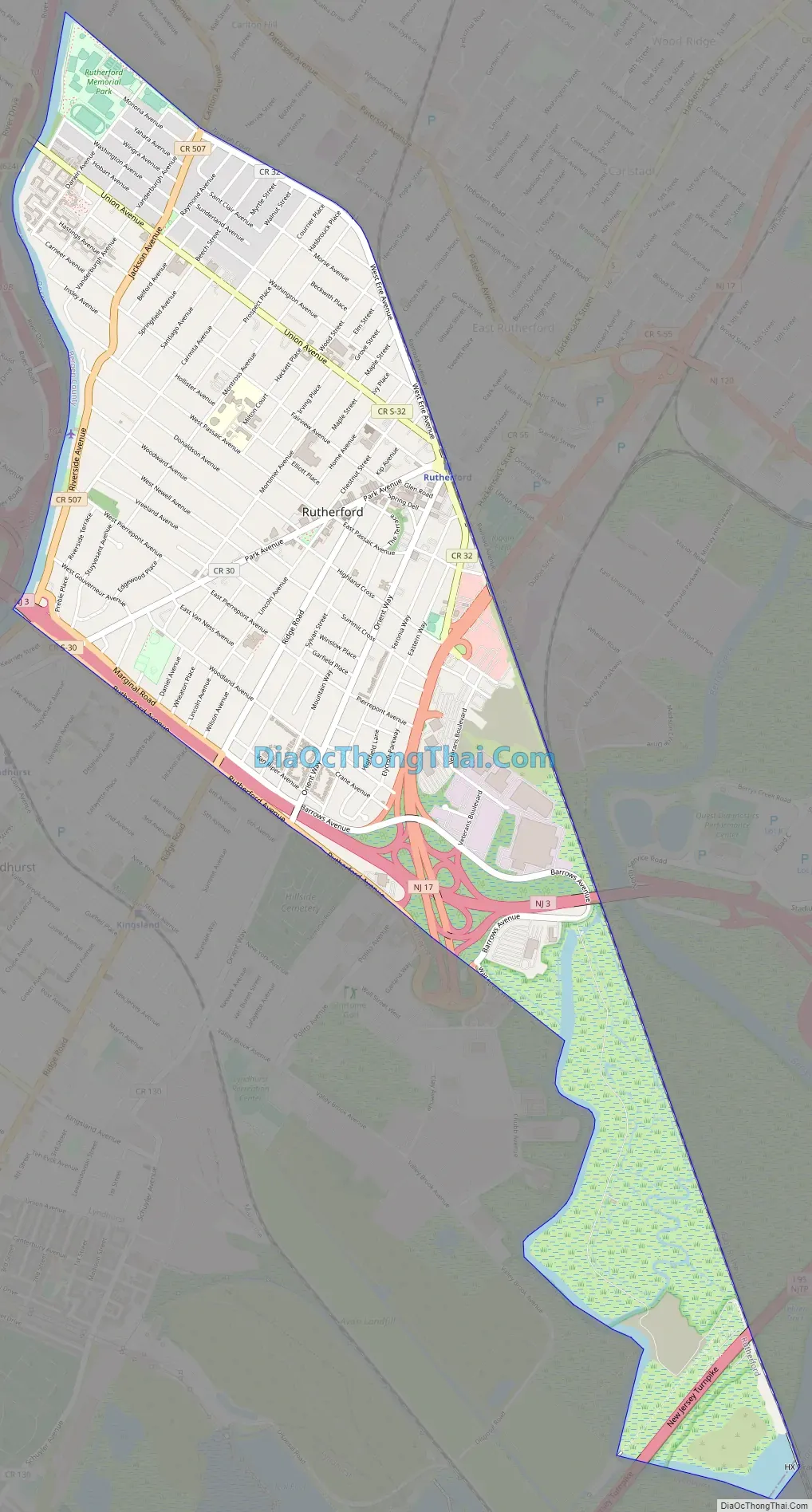
Rutherford Road Map
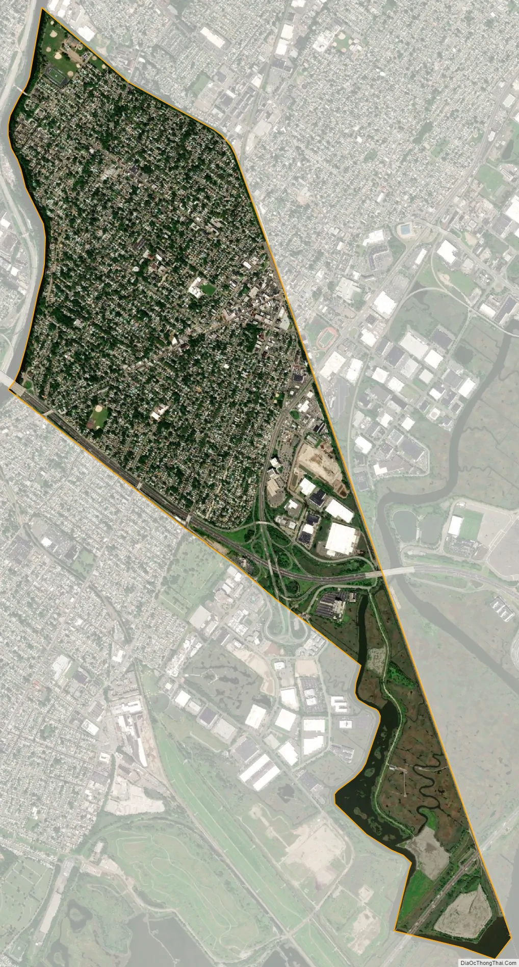
Rutherford city Satellite Map
Geography
According to the United States Census Bureau, the borough had a total area of 2.89 square miles (7.49 km), including 2.78 square miles (7.20 km) of land and 0.11 square miles (0.29 km) of water (3.88%).
Rutherford is an inner-ring suburb of New York City, located 8 miles (13 km) west of Midtown Manhattan.
The borough is bounded by the Passaic River bordering Clifton and Passaic in Passaic County to the west, the Erie Railroad bordering East Rutherford to the north and east, the Hackensack River bordering Secaucus to the southeast, and Berrys Creek, Wall Street West and Rutherford Avenue bordering Lyndhurst to the south and southwest.
See also
Map of New Jersey State and its subdivision: Map of other states:- Alabama
- Alaska
- Arizona
- Arkansas
- California
- Colorado
- Connecticut
- Delaware
- District of Columbia
- Florida
- Georgia
- Hawaii
- Idaho
- Illinois
- Indiana
- Iowa
- Kansas
- Kentucky
- Louisiana
- Maine
- Maryland
- Massachusetts
- Michigan
- Minnesota
- Mississippi
- Missouri
- Montana
- Nebraska
- Nevada
- New Hampshire
- New Jersey
- New Mexico
- New York
- North Carolina
- North Dakota
- Ohio
- Oklahoma
- Oregon
- Pennsylvania
- Rhode Island
- South Carolina
- South Dakota
- Tennessee
- Texas
- Utah
- Vermont
- Virginia
- Washington
- West Virginia
- Wisconsin
- Wyoming


