Map of Mount Pleasant town, North Carolina

Map of Mount Pleasant town, North Carolina

Mount Pleasant is a town located in eastern Cabarrus County, North Carolina, United States. As of the 2010 census, the town population was 1,652. The town center is located at the crossroads of Mount Pleasant Road and North Carolina Highway 73. NC Highway 49 skirts the town to the north on its way from Charlotte … Read more

Map of Mount Olive town, North Carolina

Map of Mount Olive town, North Carolina

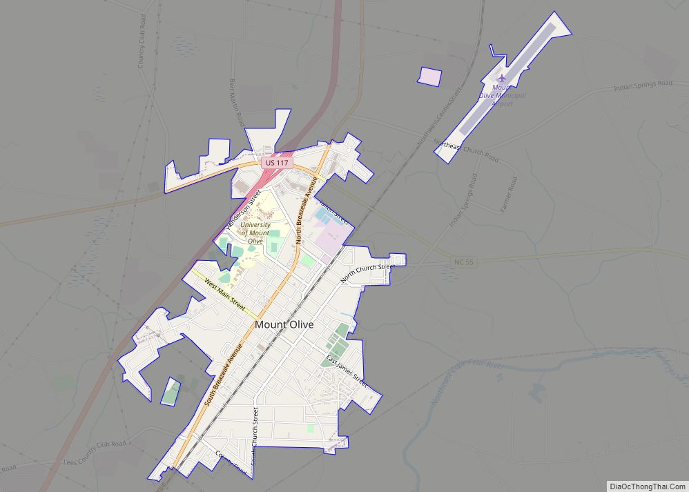
Mount Olive is a town in Duplin and Wayne counties in the U.S. state of North Carolina. The population was 4,589 at the 2010 census. It is included in the Goldsboro, North Carolina Metropolitan Statistical Area. The town is home to the Mt. Olive Pickle Company and the University of Mount Olive. Mount Olive town … Read more

Map of New London town, North Carolina

Map of New London town, North Carolina

New London is a town in Stanly County, North Carolina, United States. The population was 600 at the 2010 census, and was estimated to be 724 as of 2019. The town lies between Albemarle and Richfield along U.S. 52 in the southern Piedmont region of the state, approximately 45 miles (72 km) east-northeast of Charlotte. It … Read more

Map of New Bern city

Map of New Bern city

New Bern, formerly called Newbern, is a city in Craven County, North Carolina, United States. As of the 2010 census it had a population of 29,524, which had risen to 31,291 people as of the 2020 census. It is located at the confluence of the Neuse and the Trent rivers, near the North Carolina coast. … Read more

Map of Neuse Forest CDP

Map of Neuse Forest CDP

Neuse Forest is a census-designated place (CDP) in Craven County, North Carolina, United States. The population was 2,005 at the 2010 census. It is part of the New Bern, North Carolina Metropolitan Statistical Area. Neuse Forest CDP overview: Name: Neuse Forest CDP LSAD Code: 57 LSAD Description: CDP (suffix) State: North Carolina County: Craven County … Read more

Map of Navassa town

Map of Navassa town

Navassa is a town in Brunswick County, North Carolina, United States. The population was 1,505 at the 2010 census, up from 479 in 2000. Navassa is part of the Wilmington, North Carolina metropolitan area. Navassa town overview: Name: Navassa town LSAD Code: 43 LSAD Description: town (suffix) State: North Carolina County: Brunswick County Elevation: 16 ft … Read more

Map of Nashville town, North Carolina

Map of Nashville town, North Carolina

Nashville is a town in Nash County, North Carolina, United States. The town was founded in 1780 and features Victorian and Queen Anne style homes. It is part of the Rocky Mount, North Carolina Metropolitan Statistical Area. The population of Nashville was 5,632 in 2020. It is the county seat of Nash County. The town … Read more

Map of Nags Head town

Map of Nags Head town

Nags Head is a town in Dare County, North Carolina, United States. It is a busy vacation spot because of its beaches and sand dunes of Jockey’s Ridge. The population was 3,146 at the 2020 census. Nags Head town overview: Name: Nags Head town LSAD Code: 43 LSAD Description: town (suffix) State: North Carolina County: … Read more

Map of Myrtle Grove CDP, North Carolina

Map of Myrtle Grove CDP, North Carolina

Myrtle Grove is a census-designated place (CDP) in New Hanover County, North Carolina, United States. The population was 8,875 at the 2010 census. It is part of the Wilmington Metropolitan Statistical Area. Myrtle Grove CDP overview: Name: Myrtle Grove CDP LSAD Code: 57 LSAD Description: CDP (suffix) State: North Carolina County: New Hanover County Elevation: … Read more

Map of Newton Grove town

Map of Newton Grove town

Newton Grove, chartered in 1879, is a town in Sampson County, North Carolina, United States. The population was 569 as of the 2010 census. Newton Grove town overview: Name: Newton Grove town LSAD Code: 43 LSAD Description: town (suffix) State: North Carolina County: Sampson County Elevation: 180 ft (55 m) Total Area: 3.10 sq mi (8.02 km²) Land Area: 3.08 sq mi … Read more

Map of Newport town, North Carolina

Map of Newport town, North Carolina

Newport is a town in Carteret County, North Carolina, United States. The population was 4,510 at the 2010 census. Newport town overview: Name: Newport town LSAD Code: 43 LSAD Description: town (suffix) State: North Carolina County: Carteret County Elevation: 20 ft (6 m) Total Area: 7.75 sq mi (20.08 km²) Land Area: 7.69 sq mi (19.91 km²) Water Area: 0.06 sq mi (0.16 km²) Total Population: … Read more

Map of Newland town

Map of Newland town

Newland is a town in Avery County, North Carolina, United States. The population was 698 at the 2010 census. It is the county seat of Avery County. Newland town overview: Name: Newland town LSAD Code: 43 LSAD Description: town (suffix) State: North Carolina County: Avery County Founded: 1911 Incorporated: 1913 Elevation: 3,606 ft (1,099 m) Total Area: … Read more