Map of Walnut Creek village, North Carolina

Map of Walnut Creek village, North Carolina

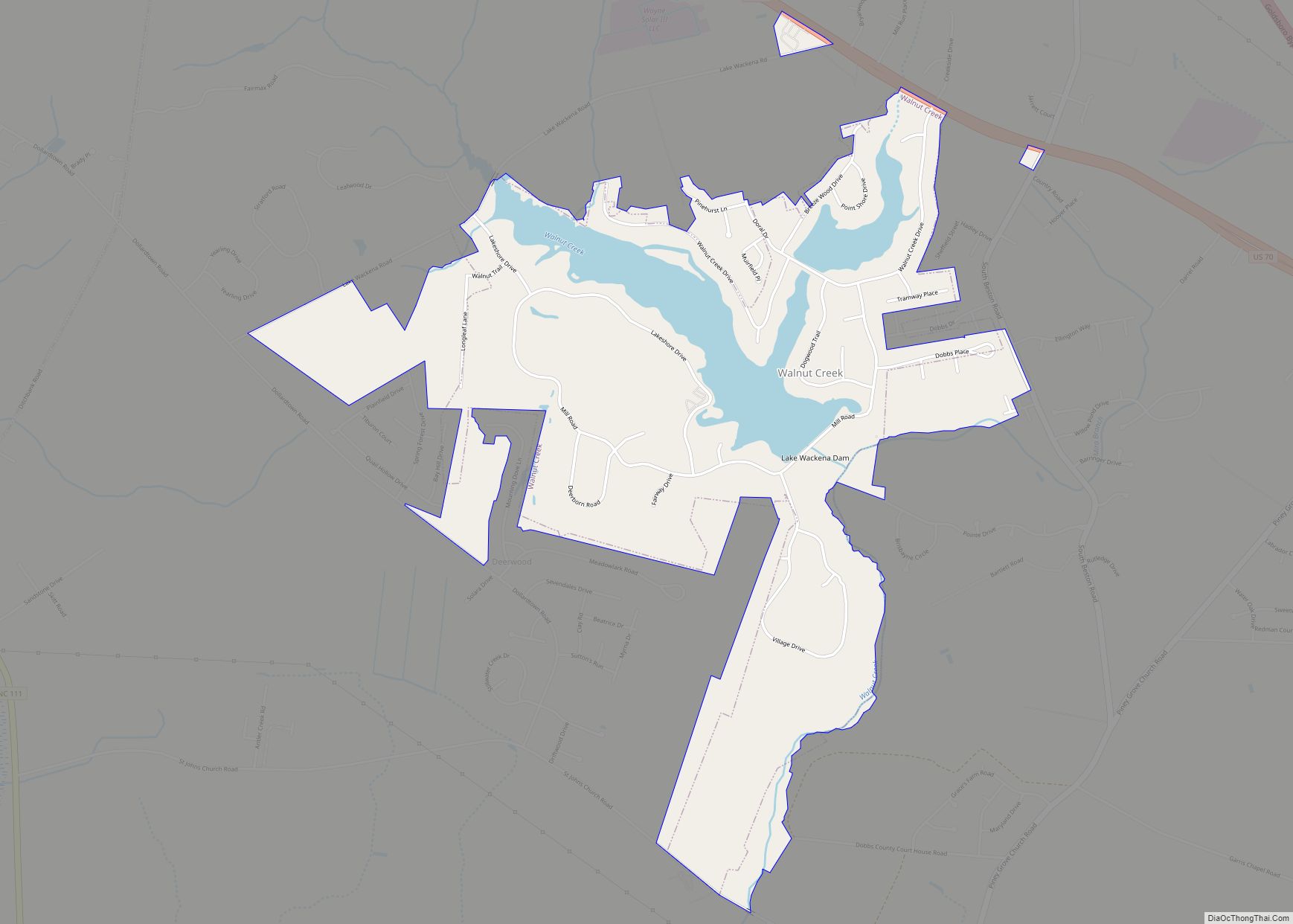
Walnut Creek is a village in Wayne County, North Carolina, United States. The population was 835 in 2010. It is included in the Goldsboro, North Carolina Metropolitan Statistical Area. The village is built around the Walnut Creek Country Club. Walnut Creek village overview: Name: Walnut Creek village LSAD Code: 47 LSAD Description: village (suffix) State: … Read more

Map of Walnut Cove town

Map of Walnut Cove town

Walnut Cove is a town in Stokes County, North Carolina, United States. The population was 1,536 at the 2020 census. It is the home of Family Pharmacy and the Walnut Cove Springfest, which draws many visitors to the area. Festival-organizers marked 1889, the town’s incorporation date, but the town’s roots date to the mid-18th century … Read more

Map of Weddington town

Map of Weddington town

Weddington is a suburban town in Union County, North Carolina, United States. A small portion of the town extends into Mecklenburg County. The population was 9,459 at the 2010 census. It is a suburb in the Charlotte metropolitan area. The current mayor of Weddington is Craig Horn. Weddington town overview: Name: Weddington town LSAD Code: … Read more

Map of Webster town, North Carolina

Map of Webster town, North Carolina

Webster is a town in Jackson County, North Carolina, United States. As of the 2010 census, the population was 363, down from 486 in 2000. Webster was the first county seat of Jackson County, until Sylva assumed the role in 1913. Webster town overview: Name: Webster town LSAD Code: 43 LSAD Description: town (suffix) State: … Read more

Map of Weaverville town, North Carolina

Map of Weaverville town, North Carolina

Weaverville is a town in Buncombe County, North Carolina, United States. The population was 3,120 at the 2010 census. It is part of the Asheville Metropolitan Statistical Area. Weaverville town overview: Name: Weaverville town LSAD Code: 43 LSAD Description: town (suffix) State: North Carolina County: Buncombe County Elevation: 2,178 ft (664 m) Total Area: 3.89 sq mi (10.07 km²) Land … Read more

Map of Waynesville town, North Carolina

Map of Waynesville town, North Carolina

Waynesville is the county seat of Haywood County, North Carolina. It is the largest town in North Carolina west of Asheville. Waynesville is located about 30 miles (50 km) southwest of Asheville between the Great Smoky and Blue Ridge Mountains. As of the 2010 census, Waynesville had a population of 9,869. The town is located just … Read more

Map of Waxhaw town

Map of Waxhaw town

Waxhaw is a town in Union County, North Carolina, United States. The population was 20,534 according to the 2020 Census. The population grew 108.28% from 2010. The name is derived from the indigenous people who lived in the area, who were known as the Waxhaw people. Waxhaw town overview: Name: Waxhaw town LSAD Code: 43 … Read more

Map of Wesley Chapel village, North Carolina

Map of Wesley Chapel village, North Carolina

Wesley Chapel is a village in Union County, North Carolina, United States. The population was 8,681 at the 2020 census and was estimated to be 8,883 in 2021. Wesley Chapel village overview: Name: Wesley Chapel village LSAD Code: 47 LSAD Description: village (suffix) State: North Carolina County: Union County Elevation: 617 ft (188 m) Total Area: 9.80 sq mi … Read more

Map of Wentworth town, North Carolina

Map of Wentworth town, North Carolina

Wentworth is a town in Rockingham County, North Carolina, United States. The population was 2,646 at the 2020 census. Wentworth is the county seat of Rockingham County and is part of the Greensboro–High Point metropolitan area of the Piedmont Triad. On May 6, 2022, and EF-1 Tornado hit Wentworth. The storm traveled as a supercell … Read more

Map of Wendell town, North Carolina

Map of Wendell town, North Carolina

Wendell is a town in Wake County, North Carolina, United States. It is a satellite town of Raleigh, the state capital. The population was 5,845 at the 2010 census. Wendell town overview: Name: Wendell town LSAD Code: 43 LSAD Description: town (suffix) State: North Carolina County: Wake County Incorporated: 1903 Elevation: 318 ft (97 m) Total Area: … Read more

Map of Weldon town, North Carolina

Map of Weldon town, North Carolina

Weldon is a town in Halifax County, North Carolina, United States. The population was 1,655 at the 2010 census. It is part of the Roanoke Rapids, North Carolina Micropolitan Statistical Area. Weldon town overview: Name: Weldon town LSAD Code: 43 LSAD Description: town (suffix) State: North Carolina County: Halifax County Elevation: 72 ft (22 m) Total Area: … Read more

Map of Welcome CDP, North Carolina

Map of Welcome CDP, North Carolina

Welcome is a census-designated place (CDP) in Davidson County, North Carolina, United States. The population was 4,162 at the 2010 census. It is nationally known as the home of Richard Childress Racing. In addition, Walker and Associates, Inc., a nationwide communication value-add distribution is headquartered here. The town motto is “Welcome to Welcome, A Friendly … Read more