Tenkiller is an unincorporated community and census-designated place (CDP) in Cherokee County, Oklahoma, United States. The population was 633 at the 2010 census. Tenkiller CDP overview: Name: Tenkiller CDP LSAD Code: 57 LSAD Description: CDP (suffix) State: Oklahoma County: Cherokee County Elevation: 892 ft (272 m) Total Area: 16.42 sq mi (42.54 km²) Land Area: 15.67 sq mi (40.58 km²) Water Area: 0.76 sq mi ... Read more
Oklahoma Cities and Places
Temple is a town in Cotton County, Oklahoma, United States. It is 5 miles (8.0 km) south and 5 miles (8.0 km) east of Walters, the county seat. The population was 1,002 at the 2010 census, a decline of 12.6 percent from 1,146 at the 2000 census. The town is named for the celebrated trial lawyer of ... Read more
Tecumseh (Meskwaki: Takamithîheki) is a city in Pottawatomie County, Oklahoma. The population was 6,457 at the 2010 census, a 5.9 percent increase from the figure of 6,098 in 2000. It was named for the noted Shawnee chief, Tecumseh. It was designated as the county seat at Oklahoma’s statehood, but a county-wide election moved the seat ... Read more
Tatums is a historic Freedmen’s town in Carter County, Oklahoma, United States. The population was 151 at the 2010 census, a decline of 12.2 percent from the figure of 172 in 2000. It is part of the Ardmore, Oklahoma Micropolitan Statistical Area. Tatums town overview: Name: Tatums town LSAD Code: 43 LSAD Description: town (suffix) ... Read more
Tamaha is a town in Haskell County, Oklahoma, United States. The population was 176 at the 2010 census, a decline of 11.1 percent from the figure of 198 in 2000. Tamaha is a Choctaw word meaning town. Tamaha town overview: Name: Tamaha town LSAD Code: 43 LSAD Description: town (suffix) State: Oklahoma County: Haskell County ... Read more
Taloga is a town in Dewey County, Oklahoma, United States. The population was 299 at the 2010 census. It is the county seat of Dewey County. The town lies near the southern bank of a bend of the Canadian River, along U.S. Route 183, approximately thirty-seven miles north of Clinton. According to the Encyclopedia of ... Read more
Talihina (pronounced “tah-luh-HEE-nuh”) is a town in LeFlore County, Oklahoma, United States, its name originating from two Choctaw words, tully and hena, meaning iron road. Iron road is reference to the railroad that the town was built around. It is part of the Fort Smith, Arkansas–Oklahoma Metropolitan Statistical Area. The population was 1,114 at the ... Read more
Talala is a town in Rogers County, Oklahoma, United States. The population was 273 at the 2010 census. Talala town overview: Name: Talala town LSAD Code: 43 LSAD Description: town (suffix) State: Oklahoma County: Rogers County Elevation: 682 ft (208 m) Total Area: 0.45 sq mi (1.16 km²) Land Area: 0.45 sq mi (1.16 km²) Water Area: 0.00 sq mi (0.00 km²) Total Population: 258 Population ... Read more
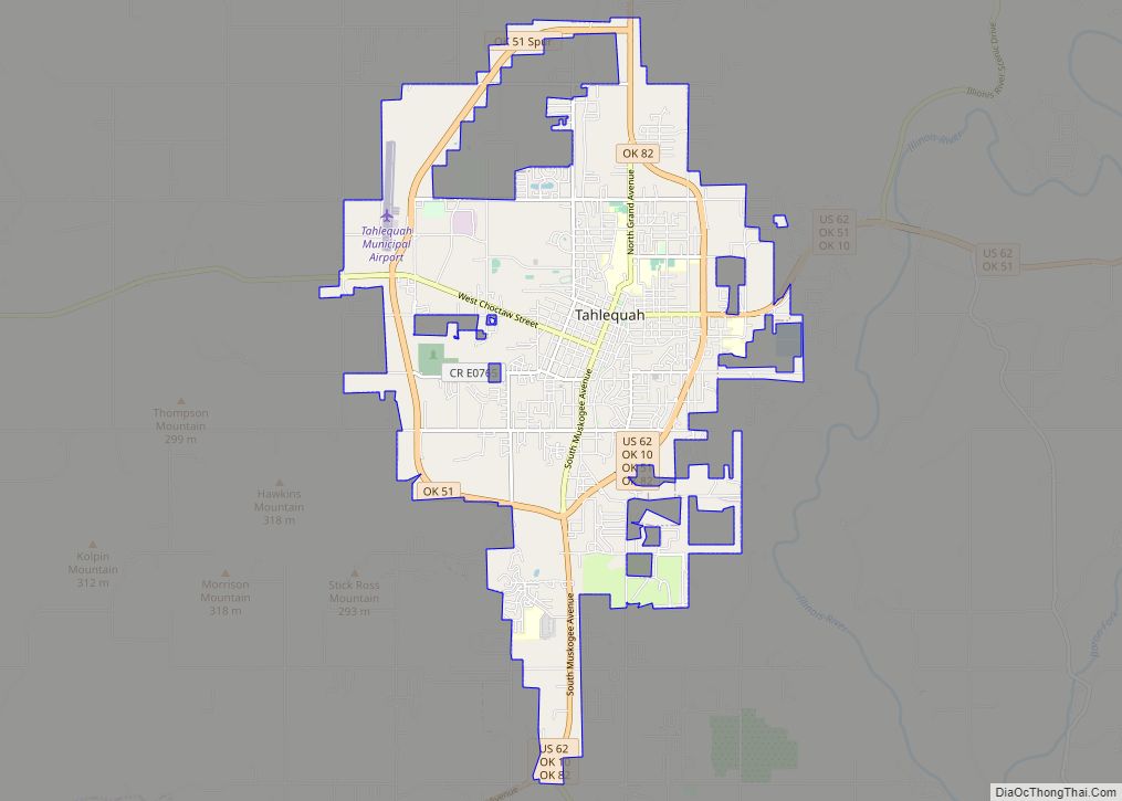
Tahlequah (/ˈtæləkwɑː/ TAL-ə-kwah; Cherokee: ᏓᎵᏆ, daligwa [dàlígʷã́]) is a city in Cherokee County, Oklahoma located at the foothills of the Ozark Mountains. It is part of the Green Country region of Oklahoma and was established as a capital of the 19th-century Cherokee Nation in 1839, as part of the new settlement in Indian Territory after ... Read more
Tagg Flats is a census-designated place (CDP) in Delaware County, Oklahoma, United States. The population was 13 at the 2010 census. Tagg Flats CDP overview: Name: Tagg Flats CDP LSAD Code: 57 LSAD Description: CDP (suffix) State: Oklahoma County: Delaware County Elevation: 961 ft (293 m) Total Area: 5.02 sq mi (13.00 km²) Land Area: 5.02 sq mi (13.00 km²) Water Area: 0.00 sq mi ... Read more
Texhoma is a town in Texas County, Oklahoma, United States. The population was 856 at the 2020 census. Texhoma is a divided city with the Texas–Oklahoma state border separating the town from Texhoma, Texas. The name of the town is a portmanteau of Texas and Oklahoma. Founded around the Rock Island Railroad laying tracks through ... Read more
Texanna is a census-designated place (CDP) in McIntosh County, Oklahoma, United States. The population was 2,083 at the 2000 census. Established in District 12 of the old Indian Territory, its post office existed from June 27, 1888 until July 16, 1940. Texanna’s population in the 1905 Territorial Census was 200. It is said to have ... Read more