Map of Cascadia CDP

Map of Cascadia CDP

Cascadia is an unincorporated community and census-designated place (CDP) that was established in 1892 on the South Santiam River, 14 miles (23 km) east of the current city of Sweet Home, in Linn County, Oregon, United States. As of the 2010 census it had a population of 147. Originally a stage stop on the Santiam Wagon … Read more

Map of Cascade Locks city

Map of Cascade Locks city

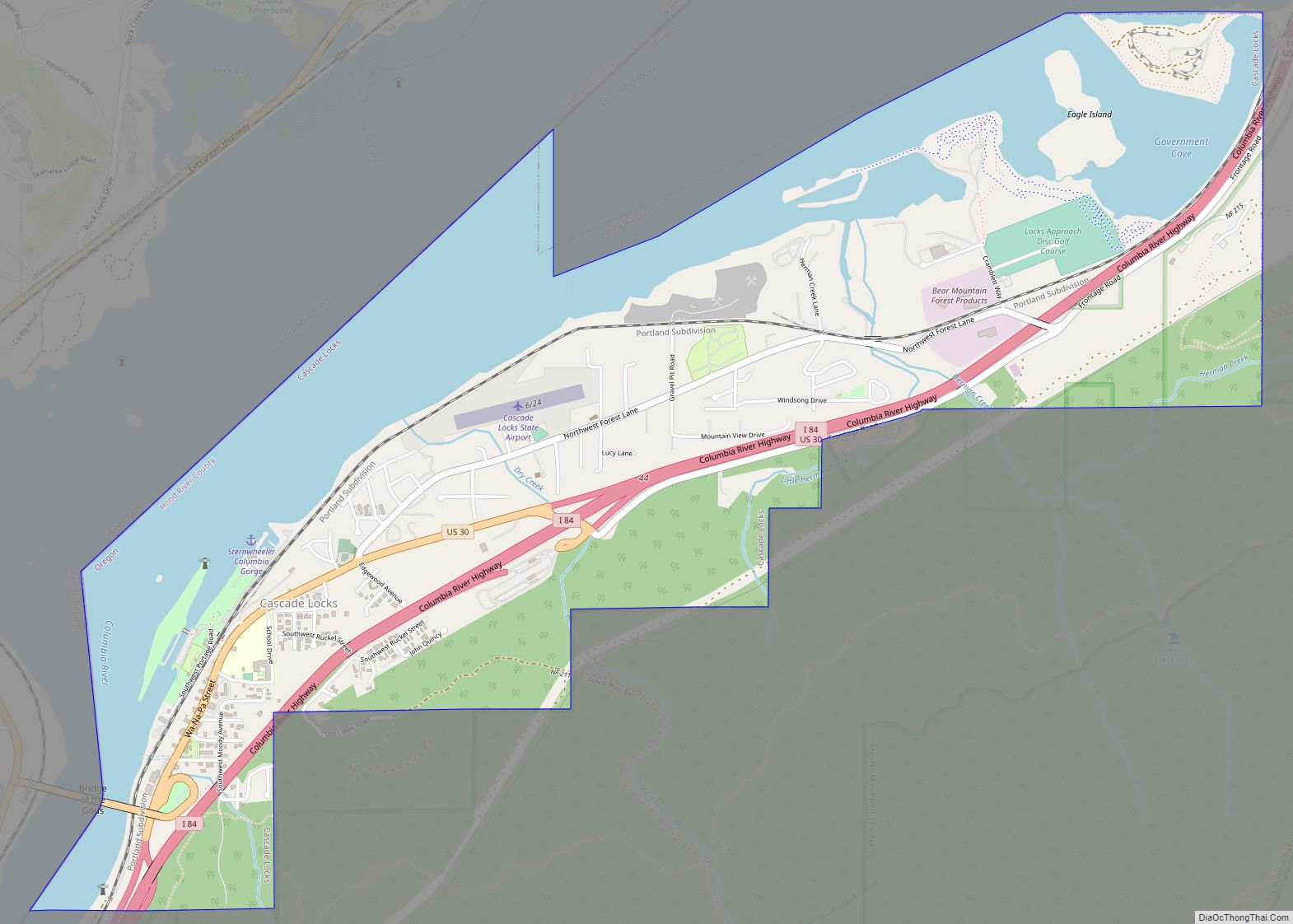
Cascade Locks is a city in Hood River County, Oregon, United States. The city got its name from a set of locks built to improve navigation past the Cascades Rapids of the Columbia River. The U.S. federal government approved the plan for the locks in 1875, construction began in 1878, and the locks were completed … Read more

Map of Carlton city, Oregon

Map of Carlton city, Oregon

Carlton is a city in Yamhill County, Oregon, United States. The population was 2,135 as of the 2020 Census. Carlton city overview: Name: Carlton city LSAD Code: 25 LSAD Description: city (suffix) State: Oregon County: Yamhill County Incorporated: 1899 Elevation: 198 ft (60.35 m) Total Area: 0.88 sq mi (2.29 km²) Land Area: 0.88 sq mi (2.29 km²) Water Area: 0.00 sq mi (0.00 km²) Total … Read more

Map of Cape Meares CDP

Map of Cape Meares CDP

Cape Meares is a census-designated place (CDP) and unincorporated community in Tillamook County, Oregon, United States. The population was 110 at the 2000 census. The community is named after the natural feature of the same name, which in turn was named after John Meares, a British explorer. The Bayocean post office was briefly renamed “Cape … Read more

Map of Condon city, Oregon

Map of Condon city, Oregon

Condon is a city in, and the seat of, Gilliam County, in the U.S. state of Oregon. The population was 682 at the 2010 census. The city, with an historic main street along Oregon Route 19, is a farming and ranching community. The John Day River/Cottonwood Canyon State Park, the ghost town of Lonerock and … Read more

Map of Columbia City, Oregon

Map of Columbia City, Oregon

Columbia City is a city in Columbia County, Oregon, United States. It was named for its location on the Columbia River. The population was 1,946 at the 2010 census. Columbia City overview: Name: Columbia City LSAD Code: 25 LSAD Description: city (suffix) State: Oregon County: Columbia County Incorporated: 1926 Elevation: 71 ft (21.6 m) Total Area: 1.16 sq mi … Read more

Map of Coburg city, Oregon

Map of Coburg city, Oregon

Coburg is a city (and a National Historic District) in Lane County, Oregon, United States, 8 miles (13 km) north of Eugene. The city’s population as of the 2020 census was 1,306. Founded in 1847, Coburg has retained the characteristics of traditional small town with walkable and close ties to the surrounding farming communities that stretch … Read more

Map of Cloverdale CDP, Oregon

Map of Cloverdale CDP, Oregon

Cloverdale is an unincorporated community in Tillamook County, Oregon, United States. For statistical purposes, the United States Census Bureau has defined Cloverdale as a census-designated place (CDP). The census definition of the area may not precisely correspond to local understanding of the area with the same name. The population was 242 at the 2000 census. … Read more

Map of Clatskanie city

Map of Clatskanie city

Clatskanie /ˈklætskɪnaɪ/ is a city in Columbia County, Oregon, United States. It was named for the Tlatskanai Native American tribe, and the Clatskanie River which flows through the town and empties into the Columbia River about four miles to the north. The population was 1,737 at the 2010 census. Clatskanie city overview: Name: Clatskanie city … Read more

Map of Chiloquin city

Map of Chiloquin city

Chiloquin (/ˈtʃɪləkwɪn/ CHIL-ə-kwin) (Klamath: mbosaksawaas, “flint place” ) is a city in Klamath County, Oregon, United States. Chiloquin was the pioneer version of a Klamath family name Chaloquin, which was the name of a Klamath chief who was alive at the time of the treaty of 1864. Southern Pacific records also show that a woman … Read more

Map of Chenoweth CDP

Map of Chenoweth CDP

Chenoweth is an unincorporated community in Wasco County, Oregon, United States. Locally the alternative spelling of Chenowith is used, such as for the ‘Chenowith Elementary School’. For statistical purposes, the United States Census Bureau has defined Chenoweth as a census-designated place (CDP). The census definition of the area may not precisely correspond to local understanding … Read more

Map of Cornelius city, Oregon

Map of Cornelius city, Oregon

Cornelius is a city in Washington County, Oregon, United States. Located in the Portland metropolitan area, the city’s population was 11,869 at the 2010 census. The city lies along Tualatin Valley Highway between Forest Grove to the west and Hillsboro to the east. Cornelius was incorporated in 1893 and is named for founder Thomas R. … Read more