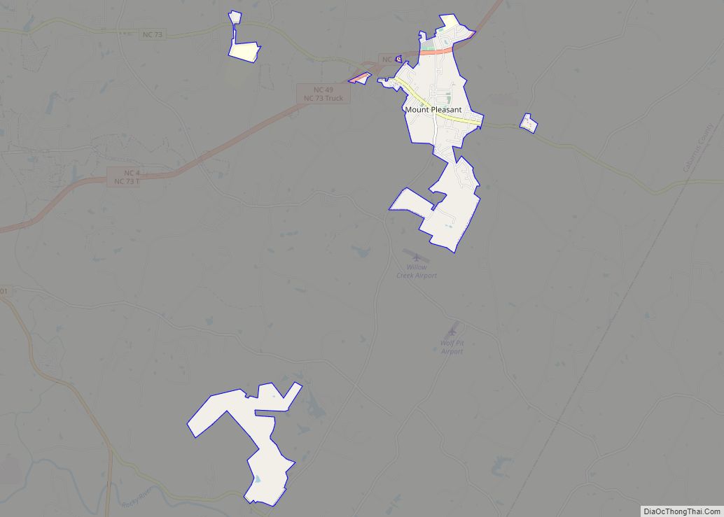
Mount Pleasant is a town located in eastern Cabarrus County, North Carolina, United States. As of the 2010 census, the town population was 1,652. The town center is located at the crossroads of Mount Pleasant Road and North Carolina Highway 73. NC Highway 49 skirts the town to the north on its way from Charlotte ... Read more
Map of US Cities and Places
Mount Olive is a town in Duplin and Wayne counties in the U.S. state of North Carolina. The population was 4,589 at the 2010 census. It is included in the Goldsboro, North Carolina Metropolitan Statistical Area. The town is home to the Mt. Olive Pickle Company and the University of Mount Olive. Mount Olive town ... Read more
Mount Holly is a small suburban city in northeastern Gaston County, North Carolina, United States. The city is situated just west of the Catawba River, north of Interstate 85, south of North Carolina State Highway 16, and west of Charlotte. The population was 17,703 at the 2020 census, up from 13,656 in 2010. Mount Holly ... Read more
Murraysville is a census-designated place (CDP) in New Hanover County, North Carolina, United States. The population was 14,215 at the 2010 census, up from 7,279 in 2000. It is part of the Wilmington Metropolitan Statistical Area. Murraysville CDP overview: Name: Murraysville CDP LSAD Code: 57 LSAD Description: CDP (suffix) State: North Carolina County: New Hanover ... Read more
Murphy is a town in and the county seat of Cherokee County, North Carolina, United States. It is situated at the confluence of the Hiwassee and Valley rivers. It is the westernmost county seat in the state of North Carolina, approximately 360 miles (580 km) from the state capital in Raleigh. The population of Murphy was ... Read more
Murfreesboro is a town in Hertford County, North Carolina, United States. The population was 2,835 at the 2010 census. The town is home to Chowan University. Murfreesboro town overview: Name: Murfreesboro town LSAD Code: 43 LSAD Description: town (suffix) State: North Carolina County: Hertford County Elevation: 85 ft (26 m) Total Area: 2.32 sq mi (6.01 km²) Land Area: 2.27 sq mi ... Read more
Mulberry is a census-designated place (CDP) in Wilkes County, North Carolina, United States. The population was 2,332 at the 2010 U.S. Census. The community was given its name by the first European pioneers to settle the area in the 1750s. These settlers called the region “Mulberry Fields”, after the many mulberry trees in the area. ... Read more
Moyock /ˈmoʊjɒk/ is an unincorporated community and census-designated place (CDP) in Currituck County, North Carolina, United States. As of the 2010 census it had a population of 3,759. Moyock CDP overview: Name: Moyock CDP LSAD Code: 57 LSAD Description: CDP (suffix) State: North Carolina County: Currituck County Elevation: 5 ft (2 m) Total Area: 10.52 sq mi (27.26 km²) Land ... Read more
Mountain View CDP overview: Name: Mountain View CDP LSAD Code: 57 LSAD Description: CDP (suffix) State: North Carolina County: Catawba County FIPS code: 3744770 Online Interactive Map Mountain View online map. Source: Basemap layers from Google Map, Open Street Map (OSM), Arcgisonline, Wmflabs. Boundary Data from Database of Global Administrative Areas. Mountain View location map. ... Read more
Newton Grove, chartered in 1879, is a town in Sampson County, North Carolina, United States. The population was 569 as of the 2010 census. Newton Grove town overview: Name: Newton Grove town LSAD Code: 43 LSAD Description: town (suffix) State: North Carolina County: Sampson County Elevation: 180 ft (55 m) Total Area: 3.10 sq mi (8.02 km²) Land Area: 3.08 sq mi ... Read more
Newport is a town in Carteret County, North Carolina, United States. The population was 4,510 at the 2010 census. Newport town overview: Name: Newport town LSAD Code: 43 LSAD Description: town (suffix) State: North Carolina County: Carteret County Elevation: 20 ft (6 m) Total Area: 7.75 sq mi (20.08 km²) Land Area: 7.69 sq mi (19.91 km²) Water Area: 0.06 sq mi (0.16 km²) Total Population: ... Read more
Newland is a town in Avery County, North Carolina, United States. The population was 698 at the 2010 census. It is the county seat of Avery County. Newland town overview: Name: Newland town LSAD Code: 43 LSAD Description: town (suffix) State: North Carolina County: Avery County Founded: 1911 Incorporated: 1913 Elevation: 3,606 ft (1,099 m) Total Area: ... Read more