Map of Malvern city, Arkansas
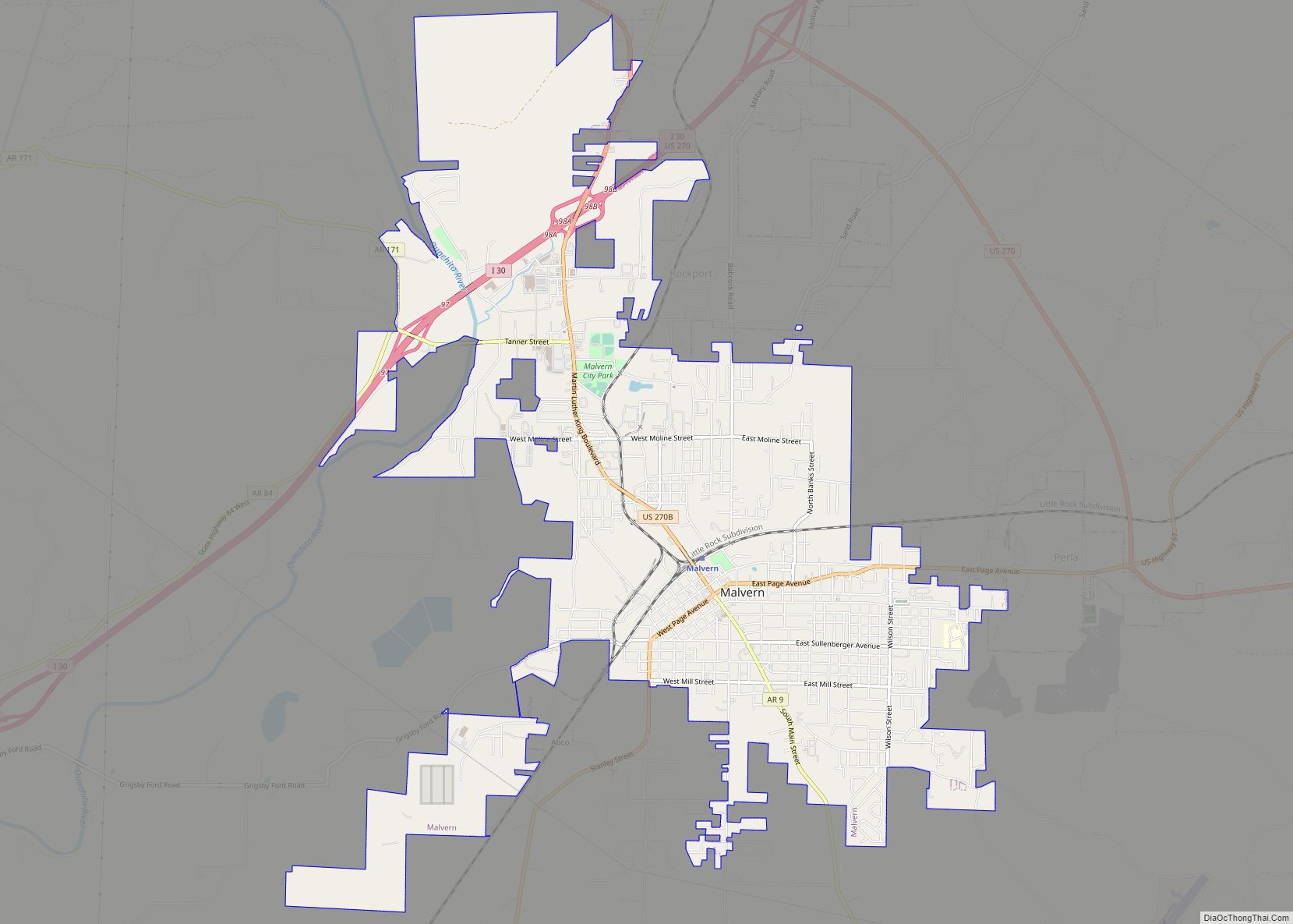
Malvern is a city in and the county seat of Hot Spring County, Arkansas, United States. Founded as a railroad stop at the eastern edge of the Ouachita Mountains, the community’s history and economy have been tied to available agricultural and mineral resources. The production of bricks from locally available clay has earned the city ... Read more
Map of Malvern city, Arkansas
Map of Magnolia city, Arkansas
Magnolia is a city in Columbia County, Arkansas, United States. As of the 2010 census the population was 11,577. The city is the county seat of Columbia County. Magnolia is home to the World’s Largest Charcoal Grill and the World Championship Steak Cookoff, part of the Magnolia Blossom Festival. Magnolia city overview: Name: Magnolia city ... Read more
Map of Magnolia city, Arkansas
Map of Magnet Cove CDP
Magnet Cove is a census-designated place (CDP) and former town in Hot Spring County, Arkansas, United States. It is located in the Ouachita Mountains southeast of Hot Springs, on Arkansas Highway 51 north of U.S. Highway 270. As of the 2020 census, the town of Magnet Cove had a population of 692. Magnet Cove CDP ... Read more
Map of Magnet Cove CDP
Map of Mansfield city, Arkansas
Mansfield is a city in Scott and Sebastian counties Arkansas, United States. The Sebastian County portion of the city is part of the Fort Smith, Arkansas–Oklahoma Metropolitan Statistical Area. As of the 2010 Census, the population was 1,139. The population was 1,097 at the 2000 census. Mansfield city overview: Name: Mansfield city LSAD Code: 25 ... Read more
Map of Mansfield city, Arkansas
Map of Manila city, Arkansas
Manila is a city in Mississippi County, Arkansas, United States. The population was 3,682 at the 2020 census, up from 3,342 in 2010. It was the hometown of World War I sniper Herman Davis. A park in the town honors his memory. Manila city overview: Name: Manila city LSAD Code: 25 LSAD Description: city (suffix) ... Read more
Map of Manila city, Arkansas
Map of Mammoth Spring city
Mammoth Spring is a city in Fulton County, Arkansas. The population was 929 at the time of the 2020 census and is home to Mammoth Spring, one of the not largest natural springs in the world, renowned for its trout fishing. Mammoth Spring city overview: Name: Mammoth Spring city LSAD Code: 25 LSAD Description: city ... Read more
Map of Mammoth Spring city
Map of Marion city, Arkansas
Marion is a city in and the county seat of Crittenden County, Arkansas, United States. The population was 12,345 at the 2010 census, a 38.7% increase since 2000. The city is part of the Memphis metropolitan area. It is the second largest city in Crittenden County, behind West Memphis. Marion city overview: Name: Marion city ... Read more
Map of Marion city, Arkansas
Map of Marie town
Marie is a town in Mississippi County, Arkansas, United States. It was founded by the R.E.L. Wilson cotton company. The population was 108 at the 2020 census. Marie town overview: Name: Marie town LSAD Code: 43 LSAD Description: town (suffix) State: Arkansas County: Mississippi County Elevation: 236 ft (72 m) Total Area: 0.15 sq mi (0.38 km²) Land Area: 0.15 sq mi ... Read more
Map of Marie town
Map of Marianna city, Arkansas
Marianna is a town in and the county seat of Lee County, Arkansas, United States. As of the 2010 census it had a population of 4,115, but by 2018 the population had dropped to an estimated 3,477. Located along the L’Anguille River in the Arkansas Delta just north of the St. Francis National Forest, the ... Read more
Map of Marianna city, Arkansas
Map of Marshall city, Arkansas
Marshall is the largest city in and county seat of Searcy County. It is located in the Ozarks at the foot of the Boston Mountain Range 10.5 mi (16.9 km) south of America’s first National River, the Buffalo National River. Marshall serves as a hub for area tourism including camping, floating, hiking, bicycling and Dark Sky viewing. ... Read more
Map of Marshall city, Arkansas
Map of Marmaduke city
Marmaduke is a city in Greene County, Arkansas, United States. The population was 1,212 in 2020. Marmaduke city overview: Name: Marmaduke city LSAD Code: 25 LSAD Description: city (suffix) State: Arkansas County: Greene County Elevation: 272 ft (83 m) Total Area: 1.40 sq mi (3.62 km²) Land Area: 1.40 sq mi (3.62 km²) Water Area: 0.00 sq mi (0.00 km²) Total Population: 1,212 Population Density: 866.95/sq mi ... Read more
Map of Marmaduke city
Map of Marked Tree city
Marked Tree is a city in Poinsett County, Arkansas, United States, along the St. Francis River, at the mouth of the Little River. The population was 2,566 at the 2010 census. It is included in the Jonesboro, Arkansas, metropolitan statistical area. Geologically, the area marks the southern end of the New Madrid Fault. Marked Tree ... Read more
Map of Marked Tree city