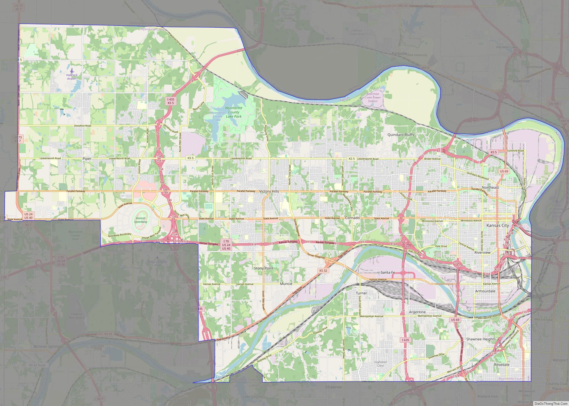
Map of Hollywood city, Florida

Map of Hollywood city, Florida

Hollywood is a city in southern Broward County, Florida, United States, located between Fort Lauderdale and Miami. As of 2020 census, Hollywood had a population of 153,061, and an estimated population of 153,131 in 2021. Founded in 1925, the city grew rapidly in the 1950s and 1960s, and is now the 12th-largest city in Florida. … Read more

Map of Escondido city

Map of Escondido city

Escondido is a city in San Diego County, California, United States. Located in the North County region, it was incorporated in 1888, and is one of the oldest cities in San Diego County. It has a population of 151,038 as of the 2020 census. Escondido city overview: Name: Escondido city LSAD Code: 25 LSAD Description: … Read more

Map of Roseville city

Map of Roseville city, California

Roseville is the most populous city in Placer County, California, located within the Sacramento metropolitan area. As of 2019, the US Census Bureau estimated the city’s population to be 141,500. Interstate 80 runs through Roseville and State Route 65 runs through part of the northern edge of the city. Roseville city overview: Name: Roseville city … Read more

Map of Bellevue city, Washington

Map of Bellevue city, Washington

Bellevue (/ˈbɛlvjuː/ BEL-vew) is a city in the Eastside region of King County, Washington, United States, located across Lake Washington from Seattle. It is the third-largest city in the Seattle metropolitan area and has variously been characterized as a satellite city, a suburb, a boomburb, or an edge city. Its population was 122,363 at the … Read more

Map of Joliet city

Map of Joliet city, Illinois

Joliet (/ˈdʒoʊliɛt, dʒoʊliˈɛt/ JOH-lee-et, joh-lee-ET) is a city in Will and Kendall counties in the U.S. state of Illinois, 35 miles (56 km) southwest of Chicago. It is the county seat of Will County. At the 2020 census, the city was the third-largest in Illinois, with a population of 150,362. Joliet city overview: Name: Joliet city … Read more

Map of Pasadena city, Texas

Map of Pasadena city, Texas

Pasadena (/ˌpæsəˈdiːnə/) is a city in the U.S. state of Texas, within the Houston–The Woodlands–Sugar Land metropolitan area. As of the 2020 U.S. census, the city’s population was 151,950, making it the twentieth most populous city in the state of Texas, as well as the second-largest city in Harris County. The area was founded in … Read more

Map of Surprise city

Map of Surprise city, Arizona

Surprise is a city in Maricopa County, in the U.S. state of Arizona. The population was 143,148 at the 2020 census, up from 117,517 in 2010 and just 30,848 in 2000. The city has a 10,562-square-foot (981.2 m) Aquatics Center and Maricopa County’s northwest regional library, a $5.5 million, 20,000-square-foot (1,900 m) library, along with a 100.3 … Read more

Map of Naperville city

Map of Naperville city

Naperville (/ˈneɪpərˌvɪl/ NAY-pər-vil) is a city within the Chicago Metropolitan Area in DuPage and Will counties in the U.S. state of Illinois. It is a western suburb of Chicago located 28 miles (45 km) west of the city. Naperville was founded in 1831 by Joseph Naper. The city was established by the banks of the DuPage … Read more

Map of Pomona city

Map of Pomona city, California

Pomona is a city in eastern Los Angeles County, California. Pomona is located in the Pomona Valley, between the Inland Empire and the San Gabriel Valley. At the 2020 census, the city’s population was 151,713. The main campus of California State Polytechnic University, Pomona, also known as Cal Poly Pomona, lies partially within Pomona’s city … Read more