Map of Bridgeport city, Connecticut

Map of Bridgeport city, Connecticut

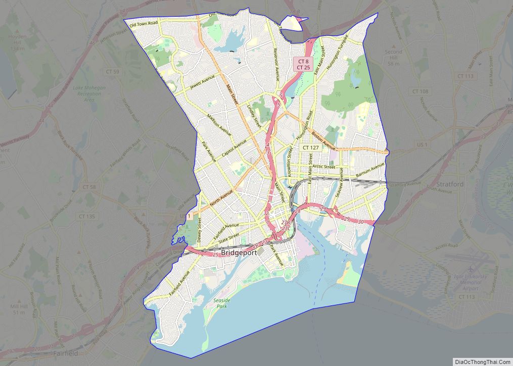
Bridgeport city overview: Name: Bridgeport city LSAD Code: 25 LSAD Description: city (suffix) State: Connecticut County: Fairfield County Elevation: 3 ft (1 m) Land Area: 16.0 sq mi (41.4 km²) Water Area: 3.4 sq mi (8.8 km²) Population Density: 7,700/sq mi (3,000/km²) Area code: 203/475 FIPS code: 0908000 GNISfeature ID: 205720 Website: bridgeportct.gov Online Interactive Map Bridgeport online map. Source: Basemap layers from Google … Read more

Map of Denton city, Texas

Map of Denton city, Texas

Denton is a city in and the county seat of Denton County, Texas, United States. With a population of 139,869 as of 2020, it is the 27th-most populous city in Texas, the 197th-most populous city in the United States, and the 12th-most populous city in the Dallas–Fort Worth metroplex. A Texas land grant led to … Read more

Map of Savannah city

Map of Savannah city, Georgia

Savannah (/səˈvænə/ sə-VAN-ə) is the oldest city in the U.S. state of Georgia and is the county seat of Chatham County. Established in 1733 on the Savannah River, the city of Savannah became the British colonial capital of the Province of Georgia and later the first state capital of Georgia. A strategic port city in … Read more

Map of Mesquite CDP, Texas

Map of Mesquite CDP, Texas

Mesquite is a census-designated place (CDP) in Starr County, Texas, United States. It is a new CDP formed from part of the former Escobares CDP prior to the 2010 census with a population of 505. Mesquite CDP overview: Name: Mesquite CDP LSAD Code: 57 LSAD Description: CDP (suffix) State: Texas County: Starr County Total Area: … Read more

Map of Torrance city

Map of Torrance city

Torrance is a city in the Los Angeles metropolitan area located in Los Angeles County, California, United States. The city is part of what is known as the South Bay region of the metropolitan area. Torrance has 1.5 miles (2.4 km) of beachfront on the Pacific Ocean and a moderate year-round climate with an average rainfall … Read more

Map of McAllen city

Map of McAllen city

McAllen is the largest city in Hidalgo County, Texas, United States, and the 22nd-most populous city in Texas. It is located at the southern tip of the state in the Rio Grande Valley, on the Mexico–United States border. The city limits extend south to the Rio Grande, across from the Mexican city of Reynosa. McAllen … Read more

Map of Syracuse city, New York

Map of Syracuse city, New York

Syracuse (/ˈsɪrəkjuːz, ˈsɛr-, -kjuːs/ SIRR-ə-kewz, SERR-, -⁠kewss) is a city in and the county seat of Onondaga County, New York, United States. It is the fifth-most populous city in the state of New York following New York City, Buffalo, Yonkers, and Rochester. At the 2020 census, the city’s population was 148,620 and its metropolitan area … Read more

Map of Visalia city

Map of Visalia city

Visalia (/vaɪˈseɪljə, vɪ-/ vy-SAYL-yə, vih-) is a city in the agricultural San Joaquin Valley of California. The population was 141,384 as per the 2020 census. Visalia is the fifth-largest city in the San Joaquin Valley, the 42nd most populous in California, and 192nd in the United States. As the county seat of Tulare County, Visalia … Read more

Map of Olathe city, Kansas

Map of Olathe city, Kansas

Olathe (/oʊˈleɪθə/ oh-LAY-tha) is the county seat of Johnson County, Kansas, United States. It is the fourth-most populous city in both the Kansas City metropolitan area and the state of Kansas, with a 2020 population of 141,290. Olathe city overview: Name: Olathe city LSAD Code: 25 LSAD Description: city (suffix) State: Kansas County: Johnson County … Read more

Map of Thornton city, Colorado

Map of Thornton city, Colorado

The City of Thornton is a home rule municipality located in Adams and Weld counties, Colorado, United States. The city population was 141,867, all in Adams County, at the 2020 United States Census, an increase of +19.44% since the 2010 United States Census. Thornton is the sixth most populous city in Colorado and the 191st … Read more

Map of Fullerton city

Map of Fullerton city, California

Fullerton (/ˈfʊlərtən/ FUUL-ər-tən) is a city located in northern Orange County, California, United States. As of the 2020 census, the city had a total population of 143,617. Fullerton was founded in 1887. It secured the land on behalf of the Atchison, Topeka and Santa Fe Railway. Historically it was a center of agriculture, notably groves … Read more