Visalia (/vaɪˈseɪljə, vɪ-/ vy-SAYL-yə, vih-) is a city in the agricultural San Joaquin Valley of California. The population was 141,384 as per the 2020 census. Visalia is the fifth-largest city in the San Joaquin Valley, the 42nd most populous in California, and 192nd in the United States. As the county seat of Tulare County, Visalia serves as the economic and governmental center to one of the most productive agricultural counties in the country.
Yosemite, Sequoia, and Kings Canyon National Parks are located in the nearby Sierra Nevada mountains, the highest mountain range within the contiguous United States. Visalia is 36 mi (58 km) west of Sequoia National Park, and 43 mi (69 km) south of Fresno.
| Name: | Visalia city |
|---|---|
| LSAD Code: | 25 |
| LSAD Description: | city (suffix) |
| State: | California |
| County: | Tulare County |
| Incorporated: | February 27, 1874 |
| Elevation: | 331 ft (101 m) |
| Total Area: | 37.94 sq mi (98.25 km²) |
| Land Area: | 37.91 sq mi (98.20 km²) |
| Water Area: | 0.02 sq mi (0.05 km²) 0.05% |
| Total Population: | 141,384 |
| Population Density: | 3,726.52/sq mi (1,439.02/km²) |
| ZIP code: | 93277-93279, 93290-93292 |
| Area code: | 559 |
| FIPS code: | 0682954 |
| Website: | www.visalia.city |
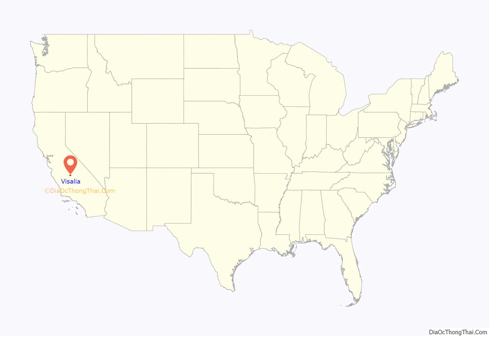
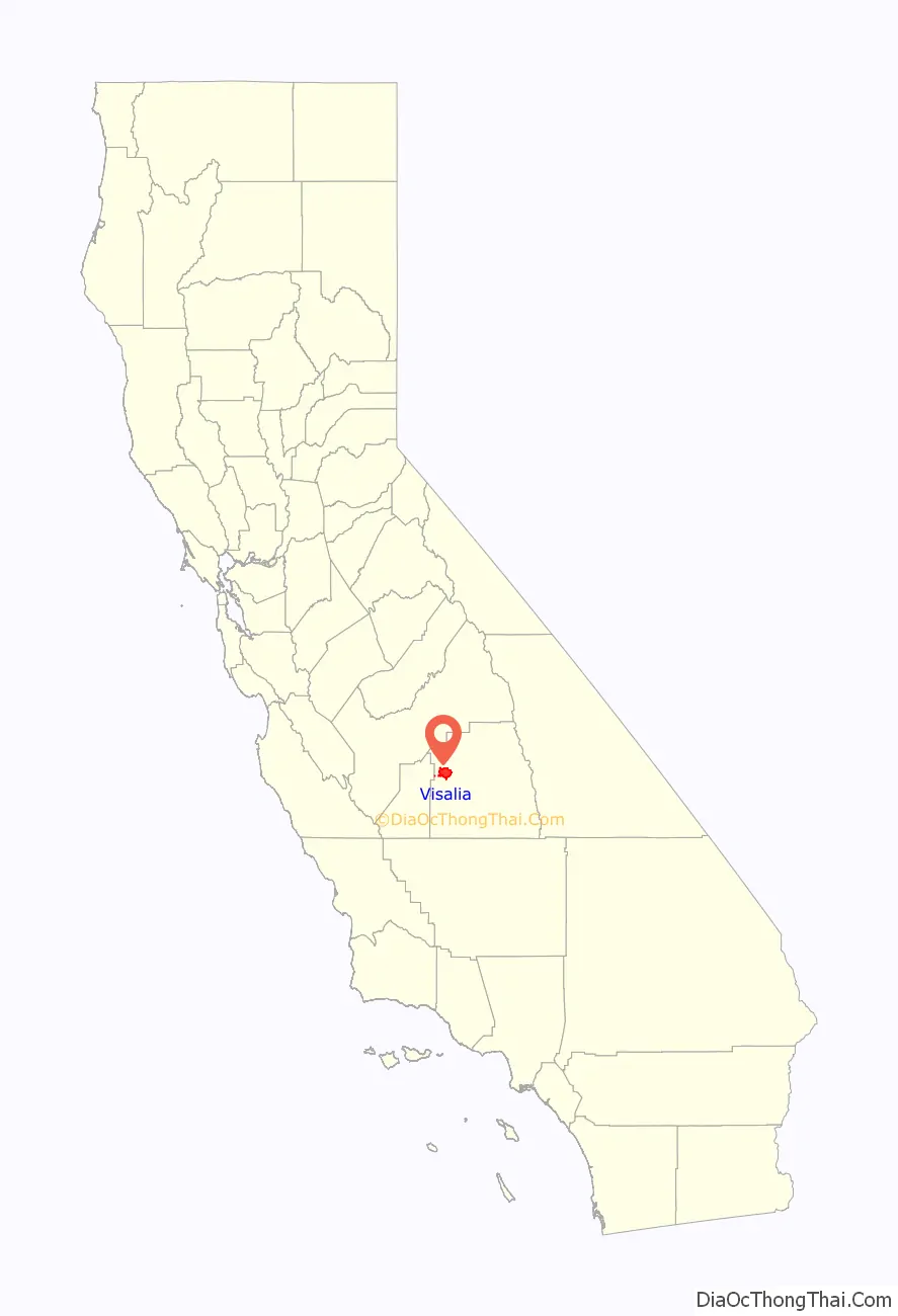
Online Interactive Map
Click on ![]() to view map in "full screen" mode.
to view map in "full screen" mode.
Visalia location map. Where is Visalia city?
History
The area around Visalia was first settled by the Yokuts and Mono Native American tribes hundreds of years ago. When the first Europeans arrived is unknown, but the first to make a written record of the area was Pedro Fages in 1722.
When California achieved statehood in 1850, Tulare County did not exist. The land that is now Tulare County was part of the vast County of Mariposa. In 1852, some pioneers settled in the area, then called Four Creeks. The area got its name from the many watershed creeks and rivers flowing from the Sierra Nevada Mountains. All the water resulted in a widespread swampy area with a magnificent oak forest. The industrious group of settlers petitioned the state legislature for county status, and on July 10 of that same year, Tulare County became a reality.
One of the first inhabitants of a fort built by the settlers was Nathaniel Vise, who was responsible for surveying the new settlement. In November 1852, he wrote, “The town contains from 60–80 inhabitants, 30 of whom are children of school age. The town is located upon one of the subdivisions of the Kaweah River and is destined to be the county seat of Tulare.” In 1853, that prediction became a reality and Visalia has remained the county seat since that time. Visalia is named for Nathaniel Vise’s ancestral home, Visalia, Kentucky.
Early growth in Visalia can be attributed in part to the gold rush along the Kern River. The gold fever brought many transient miners through Visalia along the way, and when the lure of gold failed to materialize, many returned to Visalia to live their lives and raise families. In 1859, Visalia was added to John Butterfield’s Overland Stage route from St. Louis to San Francisco. A plaque commemorating the location can be found at 116 East Main Street. Included in the early citizens were some notorious and nasty individuals who preyed upon the travelers along the Butterfield Stage route. Many saloons and hotels sprouted up around the stage stop downtown and commerce was brisk if a bit risky.
The next memorable event was the arrival of the telegraph in 1860. Visalians then could get timely information of the events taking place on the East Coast that would ultimately develop into the Civil War. During the war, many citizens of Visalia could not decide whether Visalia should stand on the side of the North or the South, so they simply had a mini Civil War of their own on Main Street. No one really knows the outcome of the war, but apparently it was concluded to the satisfaction of the participants and life returned to normal. The federal government, however, was not so easily convinced, and reacting to concern about sedition, banned Visalia’s pro-South Equal Rights Expositor newspaper and established a military garrison. Camp Babbitt was built in 1862 to stop overt Southern support and maintain law and order in the community. During these Civil War years, Visalia was incorporated, which gave the town new rights.
The second incorporation in 1874 moved Visalia into city status with a common council and an ex-officio mayor and president. In 1893, the train bandits and murderers John Sontag and Chris Evans were apprehended, badly wounded, outside Visalia in what is called the Battle of Stone Corral. Sontag died three weeks later in police custody in Fresno; Evans was sent to Folsom State Prison. In 1904, the Visalia Electric Railroad was incorporated.
In October 1933, Visalia was the site of a fact-finding committee appointed by Governor James Rolph and charged with investigating labor violence in the San Joaquin cotton strike. Labor activist Caroline Decker led hundreds of strikers in a march on the courthouse, and led the questioning of strikers during the investigation. In the mid-1970s, the area was known for the serial burglaries of the then unidentified Visalia Ransacker. More recently, Visalia served as a host city for the Amgen Tour of California in 2009 and 2010.
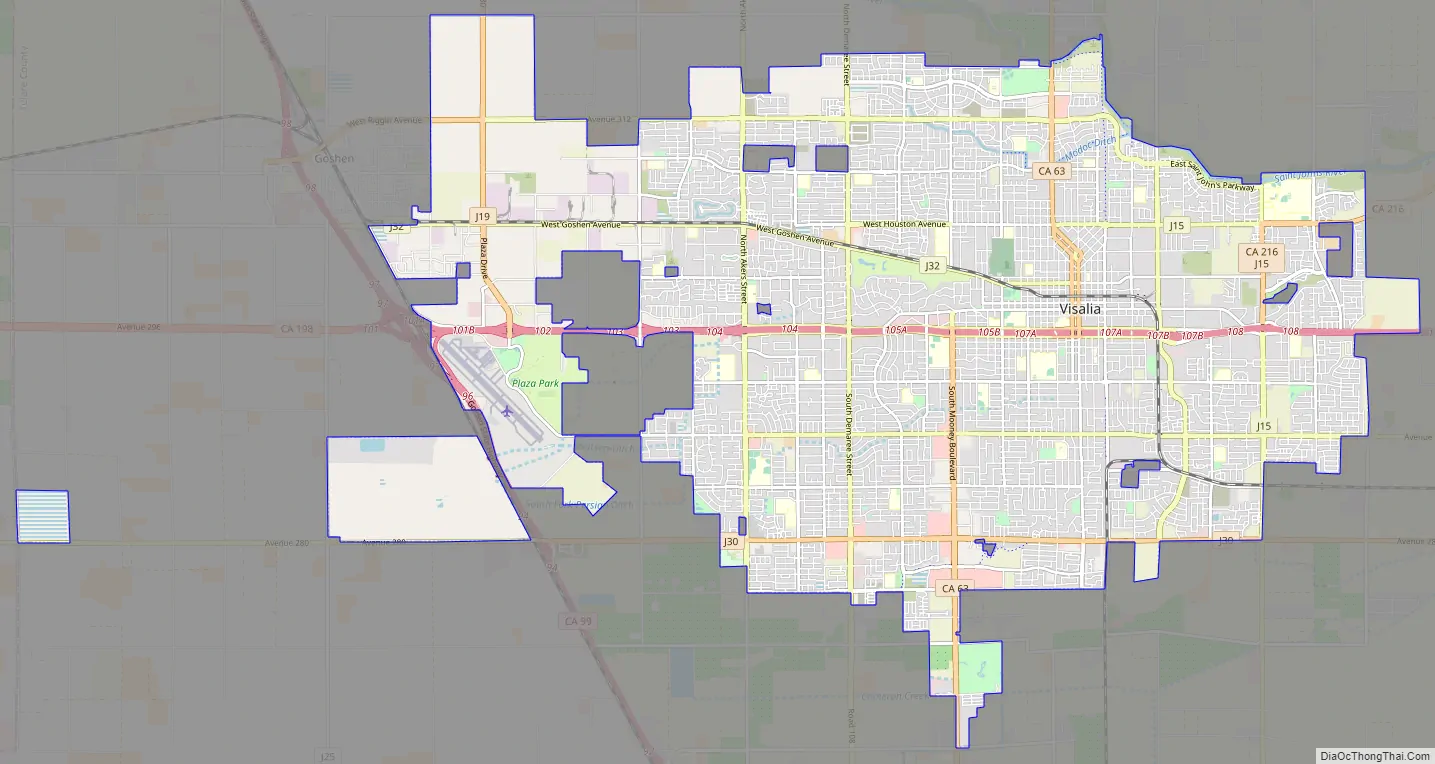
Visalia Road Map
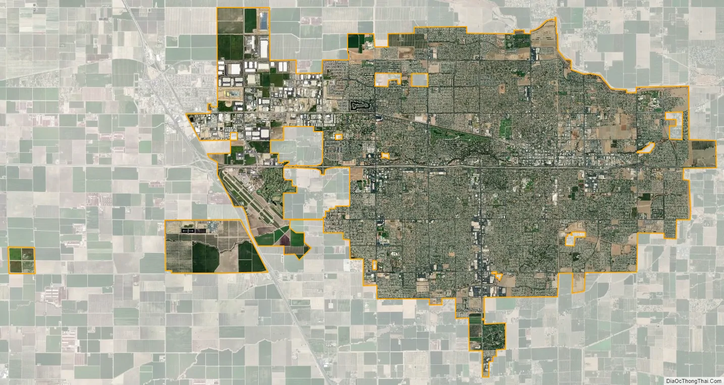
Visalia city Satellite Map
Geography
Visalia is irregularly shaped and covers a total area of 36.3 sq mi (94 km), of which 36.3 sq mi (94 km) are land and 0.05% is covered by water. Visalia is located at 36°19’27” North, 119°18’26” West (36.324100, −119.307347).
The highest point in the Visalia–Porterville area is Mount Whitney. Located at the far reaches of the Sierra Nevada roughly 58 mi (93 km) east of the city, it reaches a height of 14,505 ft (4,421 m), and was long famous as the highest mountain in the lower 48 states. The hilliest parts of the Visalia area are the Venice Hills and the entire Sierra Nevada foothills east of the city. Four main streams run through the city. The major stream is the St. John’s River, which begins at the diversion dam in the Kaweah River and is largely seasonal. The others are Mill Creek, Cameron Creek, and Packwood Creek. Many smaller creeks also flow through the city. The Friant-Kern Canal runs just east of the city along the western edge of the Sierra Nevada foothills.
Geology
Visalia is subject to earthquakes due to its proximity to the Pacific Ring of Fire. The geologic instability produces numerous fault lines both above and below ground, which altogether cause around 10,000 earthquakes every year. One of the major fault lines is the San Andreas Fault. No major earthquakes have hit the Visalia area. Most quakes are of low intensity and are not felt. The San Joaquin Valley and metropolitan areas are also at risk from blind thrust earthquakes. Parts of the city are also vulnerable to floods.
Climate
Visalia has a semi-arid climate (BSk, under the Köppen climate classification), and receives just enough annual precipitation to stay out of Köppen’s BWk (desert climate) classification. Visalia enjoys plenty of sunshine throughout the year, with an average of only 26 days with measurable precipitation annually.
The period of April through October is warm to hot and dry, with typical high temperatures of 74–94 °F (23–34 °C) and lows of 48–65 °F (9–18 °C). However, temperatures frequently exceed 100 °F (38 °C) and occasionally reach 105 °F (41 °C). The period of November through March is mild and somewhat rainy, with high temperatures of 54–67 °F (12–19 °C) and lows of 36–45 °F (2–7 °C), but temperatures could occasionally drop to high 20s (−3 °C) or be as high as 70 °F (21 °C) for a few days during winter.
Visalia averages 10.93 in (277.6 mm) of precipitation annually, which mainly occurs during the winter and spring (November through April) with generally light rain showers, but sometimes as heavy rainfall and thunderstorms. Years of average rainfall are rare; the usual pattern is bimodal, with a short string of dry years (perhaps 7–8 in [180–200 mm]) followed by one or two wet years that make up the average. While the Sierra Nevada mountains farther east in Tulare County tend to receive snow every winter, snowfall is extremely rare in Visalia. The greatest snowfall recorded in the city was just below 3 in (7.62 cm) on January 25, 1999.
Importance of the valley oak
Visalia’s Valley Oak Ordinance, adopted in 1971, regulates pruning and removing valley oak (Quercus lobata) trees. The area was once a dense oak woodland and the city is trying to maintain a healthy urban forest partly through preserving Mooney Grove Park, one of the largest valley oak groves in California. Also, just outside the city limits is the Kaweah Oaks Preserve, which is a 322-acre (1.3 km) nature preserve. It protects one of the last remaining valley oak riparian forests in the San Joaquin Valley.
Visalia was the home of the minor league baseball team the Visalia Oaks for almost 30 years. The team’s namesake was in recognition of the city’s arboreal identity and had the mascot of Oakie, and later Chatter, both gray squirrels.
Environmental issues
Owing to geography Visalia suffers from air pollution in the form of smog, agricultural and other particulates. The Visalia area and the rest of the San Joaquin Valley are susceptible to atmospheric inversion, which holds in the exhausts from road vehicles, airplanes, locomotives, manufacturing, and other sources. Unlike other cities that rely on rain to clear smog, Visalia gets only 11.03 in (280.16 mm) of rain each year; pollution accumulates over many consecutive days. Issues of air quality in Visalia and other major cities led to the passage of early national environmental legislation, including the Clean Air Act. More recently, the state of California has led the nation in working to limit pollution by mandating low emission vehicles. Particulate pollution can also be high during the winter due to frequent low-level inversions and during longer periods of dry weather. The same low-level inversions that cause high pollution levels in the winter also cause the frequent dense fog, locally known as Tule fog.
As a result, pollution levels have dropped in recent decades. The number of stage 1 smog alerts has declined from over 100 per year in the 1970s to almost zero in the new millennium. Despite improvement, the 2006 annual report of the American Lung Association ranked the city as the 11th-most polluted in the country with short-term particle pollution and year-round particle pollution. In 2007, the annual report of the American Lung Association ranked the city as the fourth-most polluted in the country with short-term particle pollution and year-round particle pollution. In 2008, the city was ranked the third-most polluted and again fourth for highest year-round particulate pollution.
See also
Map of California State and its subdivision:- Alameda
- Alpine
- Amador
- Butte
- Calaveras
- Colusa
- Contra Costa
- Del Norte
- El Dorado
- Fresno
- Glenn
- Humboldt
- Imperial
- Inyo
- Kern
- Kings
- Lake
- Lassen
- Los Angeles
- Madera
- Marin
- Mariposa
- Mendocino
- Merced
- Modoc
- Mono
- Monterey
- Napa
- Nevada
- Orange
- Placer
- Plumas
- Riverside
- Sacramento
- San Benito
- San Bernardino
- San Diego
- San Francisco
- San Joaquin
- San Luis Obispo
- San Mateo
- Santa Barbara
- Santa Clara
- Santa Cruz
- Shasta
- Sierra
- Siskiyou
- Solano
- Sonoma
- Stanislaus
- Sutter
- Tehama
- Trinity
- Tulare
- Tuolumne
- Ventura
- Yolo
- Yuba
- Alabama
- Alaska
- Arizona
- Arkansas
- California
- Colorado
- Connecticut
- Delaware
- District of Columbia
- Florida
- Georgia
- Hawaii
- Idaho
- Illinois
- Indiana
- Iowa
- Kansas
- Kentucky
- Louisiana
- Maine
- Maryland
- Massachusetts
- Michigan
- Minnesota
- Mississippi
- Missouri
- Montana
- Nebraska
- Nevada
- New Hampshire
- New Jersey
- New Mexico
- New York
- North Carolina
- North Dakota
- Ohio
- Oklahoma
- Oregon
- Pennsylvania
- Rhode Island
- South Carolina
- South Dakota
- Tennessee
- Texas
- Utah
- Vermont
- Virginia
- Washington
- West Virginia
- Wisconsin
- Wyoming


