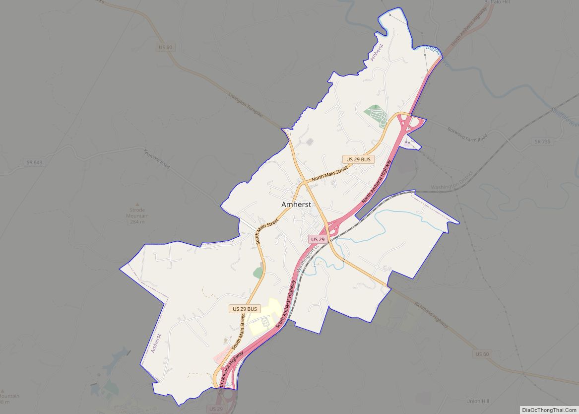
Amherst (formerly Dearborn) is a town in Amherst County, Virginia, United States. The population was 2,231 at the 2010 census. It is the county seat of Amherst County. Amherst is part of the Lynchburg Metropolitan Statistical Area. Amherst town overview: Name: Amherst town LSAD Code: 43 LSAD Description: town (suffix) State: Virginia County: Amherst County ... Read more
Map of US Cities and Places
Amelia Court House (also known as Amelia Courthouse and Amelia) is the county seat of Amelia County in the U.S. state of Virginia and a census-designated place (CDP). The population as of the 2010 census was 1,099. The town was named for Princess Amelia of Great Britain, the second daughter of Great Britain’s King George ... Read more
Altavista is an incorporated town in Campbell County, Virginia, United States. The population was 3,450 at the 2010 census. It is part of the Lynchburg Metropolitan Statistical Area. Altavista town overview: Name: Altavista town LSAD Code: 43 LSAD Description: town (suffix) State: Virginia County: Campbell County Elevation: 548 ft (167 m) Total Area: 5.24 sq mi (13.58 km²) Land Area: ... Read more
Allisonia is a census-designated place (CDP) in Pulaski County, Virginia, United States. The population as of the 2010 Census was 117. Allisonia CDP overview: Name: Allisonia CDP LSAD Code: 57 LSAD Description: CDP (suffix) State: Virginia County: Pulaski County FIPS code: 5101256 Online Interactive Map Allisonia online map. Source: Basemap layers from Google Map, Open ... Read more
Alberta is a town in Brunswick County, Virginia, United States. The population was 298 at the 2010 census. It is home to the Christanna Campus of Southside Virginia Community College. Alberta town overview: Name: Alberta town LSAD Code: 43 LSAD Description: town (suffix) State: Virginia County: Brunswick County Elevation: 397 ft (121 m) Total Area: 2.15 sq mi (5.56 km²) ... Read more
Adwolf CDP overview: Name: Adwolf CDP LSAD Code: 57 LSAD Description: CDP (suffix) State: Virginia County: Smyth County FIPS code: 5100468 Online Interactive Map Adwolf online map. Source: Basemap layers from Google Map, Open Street Map (OSM), Arcgisonline, Wmflabs. Boundary Data from Database of Global Administrative Areas. Adwolf location map. Where is Adwolf CDP? Adwolf ... Read more
Appomattox is a town in Appomattox County, Virginia, United States. The population was 1,733 at the 2010 census. It is the county seat of Appomattox County. Appomattox is part of the Lynchburg Metropolitan Statistical Area. Appomattox town overview: Name: Appomattox town LSAD Code: 43 LSAD Description: town (suffix) State: Virginia County: Appomattox County Elevation: 850 ft ... Read more
Atkins is a census-designated place (CDP) in Smyth County, Virginia, United States. The population was 1,143 at the 2010 census. Atkins CDP overview: Name: Atkins CDP LSAD Code: 57 LSAD Description: CDP (suffix) State: Virginia County: Smyth County Elevation: 2,297 ft (700 m) Total Area: 5.4 sq mi (14.0 km²) Land Area: 5.4 sq mi (14.0 km²) Water Area: 0.0 sq mi (0.0 km²) Total Population: ... Read more
Ashland is a town in Hanover County, Virginia, United States, located 16 miles (26 km) north of Richmond along Interstate 95 and U.S. Route 1. As of the 2020 census it had a population of 7,565, up from 7,225 at the 2010 census. Ashland is named after the Lexington, Kentucky estate of Hanover County native and ... Read more
Arrington CDP overview: Name: Arrington CDP LSAD Code: 57 LSAD Description: CDP (suffix) State: Virginia County: Nelson County FIPS code: 5103208 Online Interactive Map Arrington online map. Source: Basemap layers from Google Map, Open Street Map (OSM), Arcgisonline, Wmflabs. Boundary Data from Database of Global Administrative Areas. Arrington location map. Where is Arrington CDP? Arrington ... Read more
Arlington CDP overview: Name: Arlington CDP LSAD Code: 57 LSAD Description: CDP (suffix) State: Virginia County: Arlington County FIPS code: 5103000 Online Interactive Map Arlington online map. Source: Basemap layers from Google Map, Open Street Map (OSM), Arcgisonline, Wmflabs. Boundary Data from Database of Global Administrative Areas. Arlington location map. Where is Arlington CDP? Arlington ... Read more
Aquia Harbour is a census-designated place (CDP) in Stafford County, Virginia, United States, 13 miles (21 km) north of Fredericksburg. The population was 6,727 at the 2010 census. Aquia Church, erected in 1757 and now a National Historic Landmark, is located west of the community. Aquia Harbour CDP overview: Name: Aquia Harbour CDP LSAD Code: 57 ... Read more