Map of Middletown town, Virginia
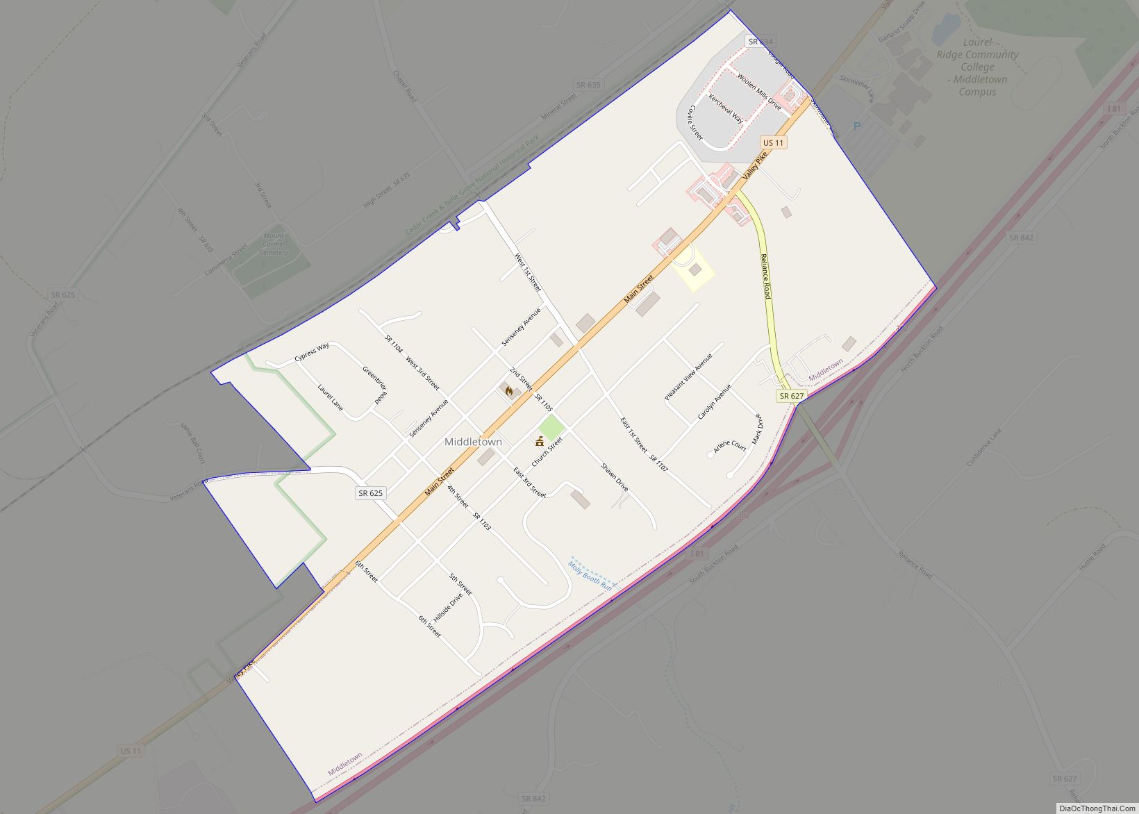
Middletown is a town in Frederick County, Virginia, United States, in the northern Shenandoah Valley. The population was 1,265 at the 2010 census, up from 1,015 at the 2000 census. Middletown town overview: Name: Middletown town LSAD Code: 43 LSAD Description: town (suffix) State: Virginia County: Frederick County Elevation: 715 ft (218 m) Total Area: 0.78 sq mi (2.01 km²) ... Read more
Map of Middletown town, Virginia
Map of Middleburg town, Virginia
Middleburg is a town in Loudoun County, Virginia, United States, with a population of 673 as of the 2010 census. It is the southernmost town along Loudoun County’s shared border with Fauquier County. Middleburg is known as the “Nation’s Horse and Hunt Capital” for its foxhunting, steeplechases, and large estates. The Middleburg Historic District, comprising ... Read more
Map of Middleburg town, Virginia
Map of Middlebrook CDP
Middlebrook is a census-designated place in Augusta County, Virginia. The population as of the 2020 Census was 184. Middlebrook Historic District, Middlebrook Schools, A. J. Miller House, Henry Mish Barn and Maple Front Farm are listed on the National Register of Historic Places. Middlebrook CDP overview: Name: Middlebrook CDP LSAD Code: 57 LSAD Description: CDP ... Read more
Map of Middlebrook CDP
Map of Metompkin CDP
Metompkin is a census-designated place (CDP) in Accomack County, Virginia, United States. Per the 2020 census, the population was 490. Metompkin CDP overview: Name: Metompkin CDP LSAD Code: 57 LSAD Description: CDP (suffix) State: Virginia County: Accomack County Elevation: 30 ft (9 m) Total Area: 490 FIPS code: 5151362 GNISfeature ID: 2584880 Online Interactive Map Metompkin online ... Read more
Map of Metompkin CDP
Map of Merrimac CDP, Virginia
Merrimac is a census-designated place (CDP) in Montgomery County, Virginia, United States. The population was 2,133 at the 2010 census. It is part of the Blacksburg–Christiansburg Metropolitan Statistical Area which encompasses all of Montgomery County and the city of Radford. Merrimac CDP overview: Name: Merrimac CDP LSAD Code: 57 LSAD Description: CDP (suffix) State: Virginia ... Read more
Map of Merrimac CDP, Virginia
Map of Montross town
Montross is a town in Westmoreland County, Virginia, United States. The population was 553 at the 2020 census. It is the county seat of Westmoreland County. Located in the historic Northern Neck of Virginia, Montross is near the George Washington Birthplace National Monument and the Stratford Hall Plantation (the birthplace of Robert E. Lee and ... Read more
Map of Montross town
Map of Montrose CDP, Virginia
Montrose is a census-designated place (CDP) in Henrico County, Virginia, United States. The population was 7,909 at the 2020 census. Montrose CDP overview: Name: Montrose CDP LSAD Code: 57 LSAD Description: CDP (suffix) State: Virginia County: Henrico County Elevation: 161 ft (49 m) Total Area: 3.3 sq mi (8.5 km²) Land Area: 3.2 sq mi (8.3 km²) Water Area: 0.08 sq mi (0.2 km²) Total Population: ... Read more
Map of Montrose CDP, Virginia
Map of Mount Vernon CDP, Virginia
Mount Vernon is a census-designated place (CDP) and unincorporated community in Fairfax County, Virginia, United States. The population was 12,416 at the 2010 census. Primarily due to its historical significance and natural recreation and beauty, the Mount Vernon area receives over one million tourists each year. While the name “Mount Vernon”—drawn from the Mount Vernon ... Read more
Map of Mount Vernon CDP, Virginia
Map of Mount Sidney CDP
Mount Sidney is a census-designated place in Augusta County, Virginia. The population as of the 2010 Census was 663. The Mt. Sidney Historic District and Mt. Sidney School are listed on the National Register of Historic Places. Mount Sidney CDP overview: Name: Mount Sidney CDP LSAD Code: 57 LSAD Description: CDP (suffix) State: Virginia County: ... Read more
Map of Mount Sidney CDP
Map of Mount Jackson town
Mount Jackson is a town in Shenandoah County, Virginia, United States. The population was 1,994 at the 2010 census. For highway travelers passing by, Mount Jackson is easily identified from I-81 exit 273 by the water tower painted as a basket of apples, which was recently repainted. For those exploring off the highway, the town ... Read more
Map of Mount Jackson town
Map of Motley CDP, Virginia
Motley is a census-designated place (CDP) in Pittsylvania County, Virginia, United States. It was named for a notable Virginia family in colonial times, the Motleys. Two of them, Joseph and his son David James Motley, fought in the American Revolution. The population as of the 2010 Census was 1,015. Motley CDP overview: Name: Motley CDP ... Read more
Map of Motley CDP, Virginia
Map of Moorefield Station CDP
Moorefield Station CDP overview: Name: Moorefield Station CDP LSAD Code: 57 LSAD Description: CDP (suffix) State: Virginia County: Loudoun County FIPS code: 5153031 Online Interactive Map Moorefield Station online map. Source: Basemap layers from Google Map, Open Street Map (OSM), Arcgisonline, Wmflabs. Boundary Data from Database of Global Administrative Areas. Moorefield Station location map. Where ... Read more
Map of Moorefield Station CDP