Map of Otterbein town
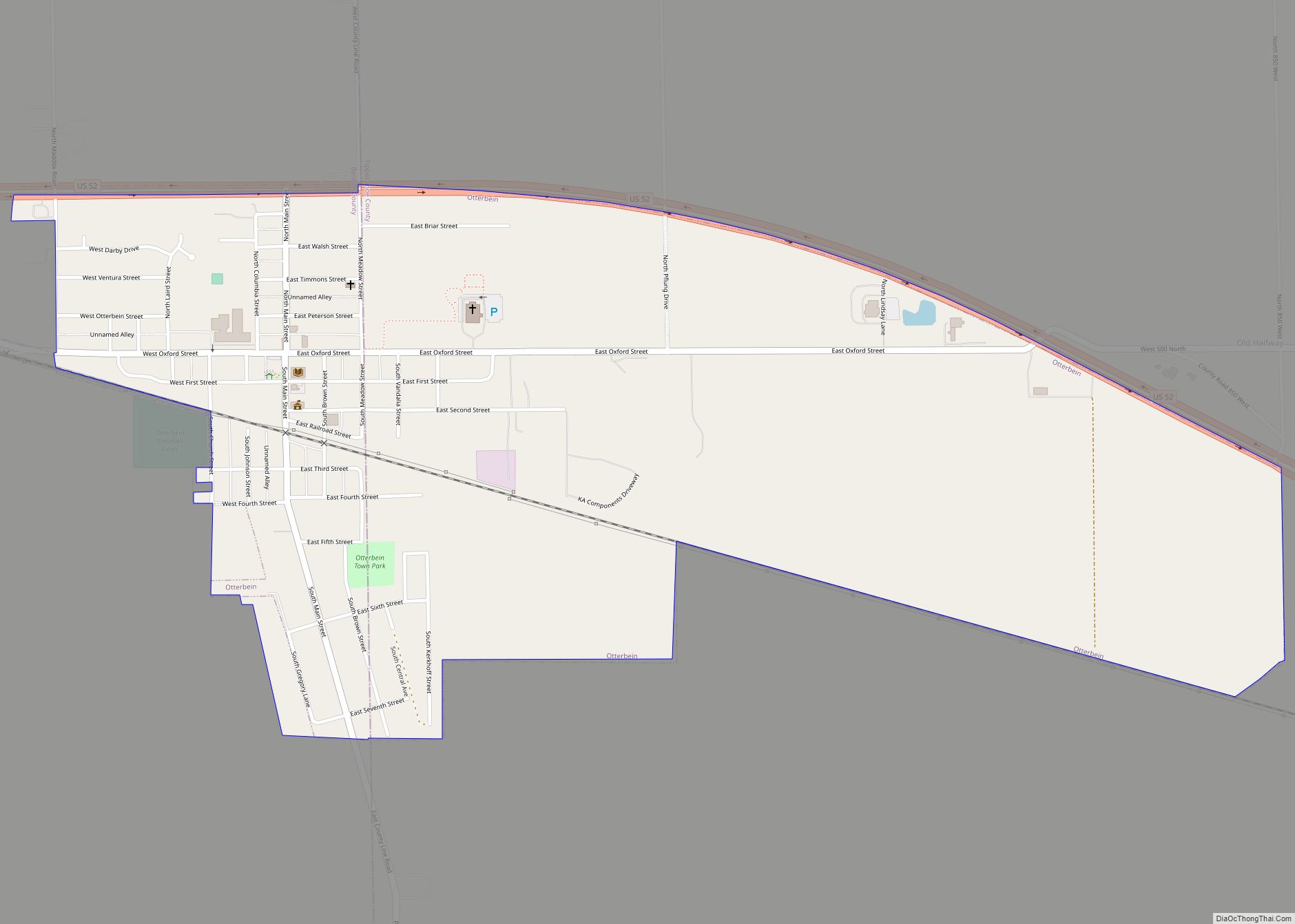
Otterbein is a town in Bolivar Township, Benton County and Shelby Township, Tippecanoe County, Indiana, named for William Otterbein Brown who donated land for the town. As of the 2010 census, its population was 1,262. It is part of the Lafayette, Indiana Metropolitan Statistical Area. Otterbein town overview: Name: Otterbein town LSAD Code: 43 LSAD ... Read more
Map of Otterbein town
Map of Ossian town, Indiana
Ossian is a town in Jefferson Township, Wells County, in the U.S. state of Indiana. The town was named after Ossian, the narrator of a cycle of epic poems by the Scottish poet James Macpherson. The population was 3,289 at the 2010 census. Ossian town overview: Name: Ossian town LSAD Code: 43 LSAD Description: town ... Read more
Map of Ossian town, Indiana
Map of Oxford town, Indiana
Oxford is a town in Oak Grove Township, Benton County, Indiana. The population was 1,162 at the 2010 census. It is part of the Lafayette, Indiana, Metropolitan Statistical Area. Oxford town overview: Name: Oxford town LSAD Code: 43 LSAD Description: town (suffix) State: Indiana County: Benton County Elevation: 735 ft (224 m) Total Area: 0.55 sq mi (1.42 km²) Land ... Read more
Map of Oxford town, Indiana
Map of Owensville town, Indiana
Owensville is the third largest town and the smallest of the five larger communities in Gibson County, Indiana, United States. The population was 1,330 in 2017. Owensville town overview: Name: Owensville town LSAD Code: 43 LSAD Description: town (suffix) State: Indiana County: Gibson County Elevation: 525 ft (160 m) Total Area: 0.57 sq mi (1.47 km²) Land Area: 0.57 sq mi (1.47 km²) ... Read more
Map of Owensville town, Indiana
Map of Owensburg CDP
Owensburg is an unincorporated community and census-designated place (CDP) in Jackson Township, Greene County, Indiana, United States. It was named in honor of the Owens family of early settlers. As of the 2010 census it had a population of 406. Owensburg CDP overview: Name: Owensburg CDP LSAD Code: 57 LSAD Description: CDP (suffix) State: Indiana ... Read more
Map of Owensburg CDP
Map of Painted Hills CDP
Painted Hills is an unincorporated community and census-designated place (CDP) in Jackson Township, Morgan County, in the U.S. state of Indiana. Its population was 766 as of the 2020 census, up from 677 in 2010. The community is located on the shores of Lake Holiday and Lake Nebo southeast of Martinsville, the Morgan county seat. ... Read more
Map of Painted Hills CDP
Map of Paoli town, Indiana
Paoli (/peɪˈoʊli/ pay-OH-lee) is a town within Paoli Township and the county seat of Orange County, in the U.S. state of Indiana. The population was 3,677 at the 2010 census. Paoli town overview: Name: Paoli town LSAD Code: 43 LSAD Description: town (suffix) State: Indiana County: Orange County Elevation: 617 ft (188 m) Total Area: 3.75 sq mi (9.72 km²) ... Read more
Map of Paoli town, Indiana
Map of Palmyra town, Indiana
Palmyra is a town in Morgan Township, Harrison County, Indiana, United States. The population was 930 at the 2010 census. Palmyra town overview: Name: Palmyra town LSAD Code: 43 LSAD Description: town (suffix) State: Indiana County: Harrison County Elevation: 774 ft (236 m) Total Area: 1.24 sq mi (3.21 km²) Land Area: 1.20 sq mi (3.10 km²) Water Area: 0.04 sq mi (0.11 km²) Total Population: ... Read more
Map of Palmyra town, Indiana
Map of Parkers Settlement CDP
Parkers Settlement is an unincorporated community and census-designated place in Robinson Township, Posey County, in the U.S. state of Indiana. Parkers Settlement CDP overview: Name: Parkers Settlement CDP LSAD Code: 57 LSAD Description: CDP (suffix) State: Indiana County: Posey County Elevation: 430 ft (130 m) Total Area: 1.75 sq mi (4.54 km²) Land Area: 1.75 sq mi (4.54 km²) Water Area: 0.00 sq mi (0.00 km²) ... Read more
Map of Parkers Settlement CDP
Map of Parker City town
Parker City is a town in Monroe Township, Randolph County, in the U.S. state of Indiana. The population was 1,419 at the 2010 census. Parker City town overview: Name: Parker City town LSAD Code: 43 LSAD Description: town (suffix) State: Indiana County: Randolph County Elevation: 1,024 ft (312 m) Total Area: 0.57 sq mi (1.49 km²) Land Area: 0.57 sq mi (1.49 km²) ... Read more
Map of Parker City town
Map of Paragon town
Paragon is a town in Ray Township, Morgan County, in the U.S. state of Indiana. The population was 556 at the 2020 census, down from 659 in 2010. Paragon town overview: Name: Paragon town LSAD Code: 43 LSAD Description: town (suffix) State: Indiana County: Morgan County Elevation: 581 ft (177 m) Total Area: 0.28 sq mi (0.71 km²) Land Area: ... Read more
Map of Paragon town
Map of Pendleton town, Indiana
Pendleton is a town in Fall Creek Township, Madison County, Indiana, United States. The population was 4,717 at the 2020 census, up from 4,253 in 2010. Pendleton town overview: Name: Pendleton town LSAD Code: 43 LSAD Description: town (suffix) State: Indiana County: Madison County Elevation: 846 ft (258 m) Total Area: 13.43 sq mi (34.79 km²) Land Area: 13.36 sq mi (34.61 km²) ... Read more
Map of Pendleton town, Indiana