Map of Remington town, Indiana
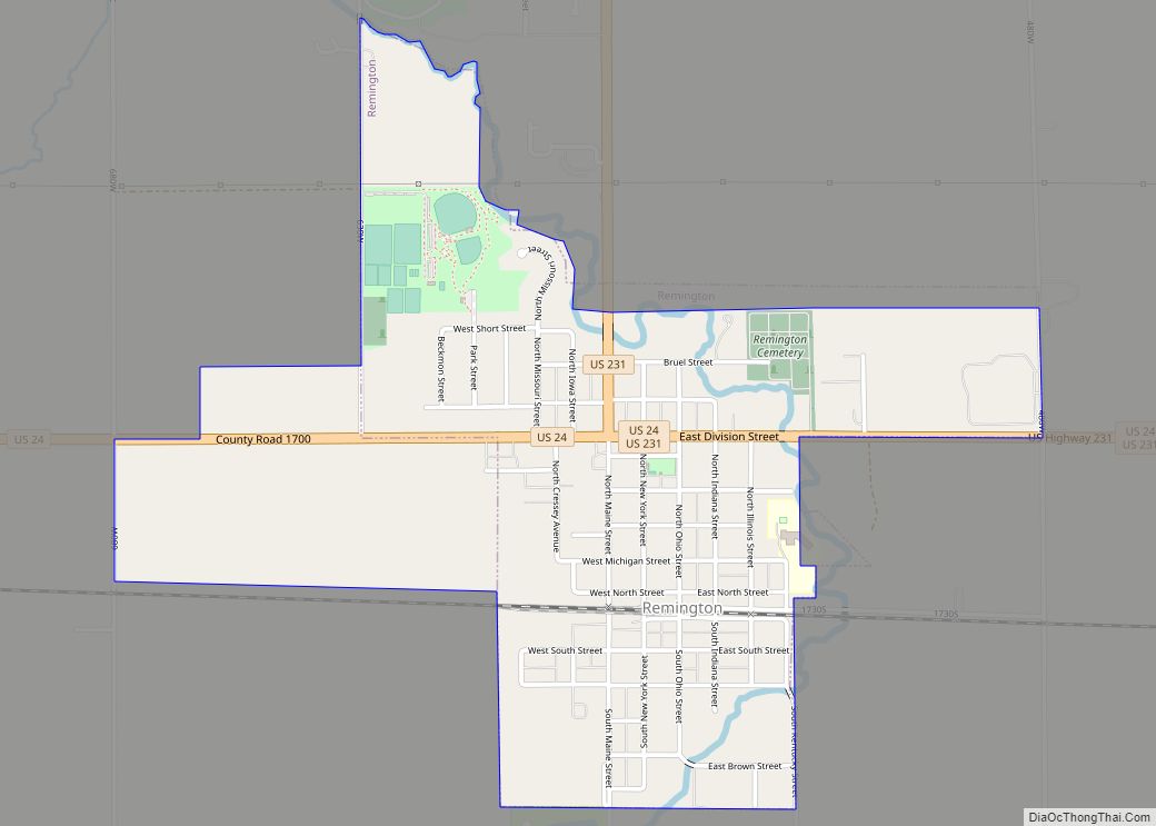
Remington is a town in Carpenter Township, Jasper County, Indiana, United States. The population was 1,185 at the 2010 census. Remington town overview: Name: Remington town LSAD Code: 43 LSAD Description: town (suffix) State: Indiana County: Jasper County Elevation: 725 ft (221 m) Total Area: 3.84 sq mi (9.95 km²) Land Area: 3.81 sq mi (9.88 km²) Water Area: 0.03 sq mi (0.07 km²) Total Population: ... Read more
Map of Remington town, Indiana
Map of Redkey town
Redkey is a town in Richland Township, Jay County, Indiana, United States. The population was 1,353 at the 2010 census. Redkey town overview: Name: Redkey town LSAD Code: 43 LSAD Description: town (suffix) State: Indiana County: Jay County Elevation: 961 ft (293 m) Total Area: 0.87 sq mi (2.26 km²) Land Area: 0.87 sq mi (2.26 km²) Water Area: 0.00 sq mi (0.00 km²) Total Population: ... Read more
Map of Redkey town
Map of Richmond city, Indiana
Richmond (/ˈrɪtʃmənd/) is a city in eastern Wayne County, Indiana, United States. Bordering the state of Ohio, it is the county seat of Wayne County. In the 2020 census, the city had a population of 35,720. It is the principal city of the Richmond micropolitan area. Situated largely within Wayne Township, its area includes a ... Read more
Map of Richmond city, Indiana
Map of Richland town, Indiana
Richland town overview: Name: Richland town LSAD Code: 43 LSAD Description: town (suffix) State: Indiana County: Spencer County FIPS code: 1864206 Online Interactive Map Richland online map. Source: Basemap layers from Google Map, Open Street Map (OSM), Arcgisonline, Wmflabs. Boundary Data from Database of Global Administrative Areas. Richland location map. Where is Richland town? Richland ... Read more
Map of Richland town, Indiana
Map of Reynolds town, Indiana
Reynolds is a town in Honey Creek Township, White County, in the U.S. state of Indiana. The population was 533 at the 2010 census. Reynolds town overview: Name: Reynolds town LSAD Code: 43 LSAD Description: town (suffix) State: Indiana County: White County Elevation: 699 ft (213 m) Total Area: 0.55 sq mi (1.43 km²) Land Area: 0.55 sq mi (1.43 km²) Water Area: ... Read more
Map of Reynolds town, Indiana
Map of Rising Sun city, Indiana
Rising Sun is a city in Randolph Township and the county seat of Ohio County, Indiana, United States, along the Ohio River. It is also the only incorporated community in the county. The population of Rising Sun was 2,304 at the 2010 census. Rising Sun city overview: Name: Rising Sun city LSAD Code: 25 LSAD ... Read more
Map of Rising Sun city, Indiana
Map of Riley town, Indiana
Riley, once known as Lockport, is a town in Riley Township, Vigo County, in the U.S. state of Indiana. The population was 221 at the 2010 census. It is part of the Terre Haute Metropolitan Statistical Area. Riley town overview: Name: Riley town LSAD Code: 43 LSAD Description: town (suffix) State: Indiana County: Vigo County ... Read more
Map of Riley town, Indiana
Map of Ridgeville town, Indiana
Ridgeville is a town in Franklin Township, Randolph County, Indiana, United States, along the Mississinewa River. The population was 803 at the 2010 census. Ridgeville town overview: Name: Ridgeville town LSAD Code: 43 LSAD Description: town (suffix) State: Indiana County: Randolph County Elevation: 997 ft (304 m) Total Area: 0.56 sq mi (1.44 km²) Land Area: 0.56 sq mi (1.44 km²) Water Area: ... Read more
Map of Ridgeville town, Indiana
Map of Roann town
Roann is a town in Paw Paw Township, Wabash County, in the U.S. state of Indiana. The population was 479 at the 2010 census. Roann town overview: Name: Roann town LSAD Code: 43 LSAD Description: town (suffix) State: Indiana County: Wabash County Elevation: 755 ft (230 m) Total Area: 0.23 sq mi (0.59 km²) Land Area: 0.23 sq mi (0.59 km²) Water Area: ... Read more
Map of Roann town
Map of Roachdale town
Roachdale is a town in Franklin and Jackson townships, Putnam County, in the U.S. state of Indiana. The population was 926 at the 2010 census. Roachdale town overview: Name: Roachdale town LSAD Code: 43 LSAD Description: town (suffix) State: Indiana County: Putnam County Elevation: 843 ft (257 m) Total Area: 0.51 sq mi (1.31 km²) Land Area: 0.51 sq mi (1.31 km²) Water ... Read more
Map of Roachdale town
Map of River Forest town, Indiana
River Forest is a town in Anderson Township, Madison County, Indiana, United States. It is part of the Indianapolis–Carmel–Anderson metropolitan statistical area. The population was 26 at the 2020 census. River Forest town overview: Name: River Forest town LSAD Code: 43 LSAD Description: town (suffix) State: Indiana County: Madison County Elevation: 873 ft (266 m) Total Area: ... Read more
Map of River Forest town, Indiana
Map of Rockport city, Indiana
Rockport is a city in Ohio Township and the county seat of Spencer County, Indiana, along the Ohio River. The population was 2,270 at the 2010 census. Once the largest community in Spencer County, the city has recently been surpassed by the town of Santa Claus. At 37°53’1″ north, Rockport is also the southernmost city ... Read more
Map of Rockport city, Indiana