Map of Troy town, Indiana
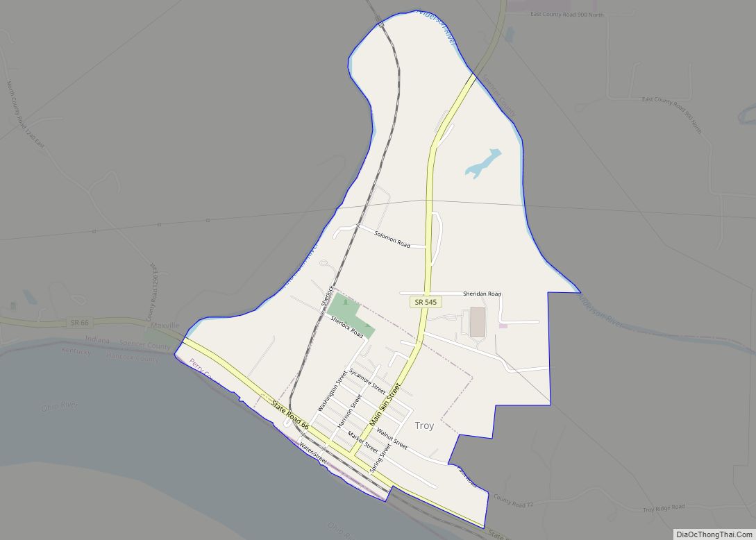
Troy is a town in Troy Township, Perry County, Indiana, along the Ohio River near the mouth of the Anderson River. It is the second oldest city in Indiana. The population was 385 at the 2010 census. Troy town overview: Name: Troy town LSAD Code: 43 LSAD Description: town (suffix) State: Indiana County: Perry County ... Read more
Map of Troy town, Indiana
Map of Tri-Lakes CDP
Tri-Lakes is an unincorporated community and census-designated place in Thorncreek and Smith townships in Whitley County, Indiana, United States. Tri-Lakes CDP overview: Name: Tri-Lakes CDP LSAD Code: 57 LSAD Description: CDP (suffix) State: Indiana County: Whitley County Elevation: 938 ft (286 m) Total Area: 4.02 sq mi (10.41 km²) Land Area: 3.42 sq mi (8.85 km²) Water Area: 0.60 sq mi (1.56 km²) Total Population: 1,329 ... Read more
Map of Tri-Lakes CDP
Map of Universal town
Universal is a town in Clinton Township, Vermillion County, in the U.S. state of Indiana. The population was 362 at the 2010 census. Universal town overview: Name: Universal town LSAD Code: 43 LSAD Description: town (suffix) State: Indiana County: Vermillion County Elevation: 581 ft (177 m) Total Area: 0.36 sq mi (0.93 km²) Land Area: 0.36 sq mi (0.93 km²) Water Area: 0.00 sq mi ... Read more
Map of Universal town
Map of Uniondale town, Indiana
Uniondale is a town in Union and Rockcreek townships, Wells County, in the U.S. state of Indiana. The population was 310 at the 2010 census. Uniondale town overview: Name: Uniondale town LSAD Code: 43 LSAD Description: town (suffix) State: Indiana County: Wells County Elevation: 814 ft (248 m) Total Area: 0.21 sq mi (0.55 km²) Land Area: 0.21 sq mi (0.54 km²) Water ... Read more
Map of Uniondale town, Indiana
Map of Union City, Indiana
Union City is a city in Wayne Township, Randolph County, Indiana, United States. As of the 2010 census, the city had a population of 3,584. Union City was a stop along the Pittsburgh, Cincinnati, Chicago and St. Louis Railroad, a forerunner of the Pennsylvania Railroad that connected Pittsburgh to Chicago and St. Louis. The Cleveland, ... Read more
Map of Union City, Indiana
Map of Vallonia CDP
Vallonia is an unincorporated community and census-designated place (CDP) in Driftwood and Brownstown townships, Jackson County, Indiana, United States. It was an 18th-century French settlement and 19th-century American frontier fortification known as Fort Vallonia. As of the 2010 census, Vallonia had a population of 336. Vallonia CDP overview: Name: Vallonia CDP LSAD Code: 57 LSAD ... Read more
Map of Vallonia CDP
Map of Utica town, Indiana
Utica is a town in Utica Township, Clark County, Indiana, United States. The population was 776 at the 2010 census. Utica town overview: Name: Utica town LSAD Code: 43 LSAD Description: town (suffix) State: Indiana County: Clark County Elevation: 443 ft (135 m) Total Area: 1.44 sq mi (3.73 km²) Land Area: 1.19 sq mi (3.08 km²) Water Area: 0.25 sq mi (0.65 km²) Total Population: ... Read more
Map of Utica town, Indiana
Map of Upland town, Indiana
Upland (pronounced as “up-land”) is a town in Jefferson Township, Grant County, Indiana, United States. The population was 3,845 at the 2010 census. It is most notable for being the home of Taylor University, a Christian college with 2,103 students, as of 2016. Upland town overview: Name: Upland town LSAD Code: 43 LSAD Description: town ... Read more
Map of Upland town, Indiana
Map of Van Buren town, Indiana
Van Buren is a town in Van Buren Township, Grant County, Indiana, United States. The population was 864 at the 2010 census. Van Buren town overview: Name: Van Buren town LSAD Code: 43 LSAD Description: town (suffix) State: Indiana County: Grant County Elevation: 846 ft (258 m) Total Area: 0.58 sq mi (1.51 km²) Land Area: 0.58 sq mi (1.51 km²) Water Area: ... Read more
Map of Van Buren town, Indiana
Map of Van Bibber Lake CDP
Van Bibber Lake is an unincorporated community and census-designated place in Clinton Township, Putnam County, in the U.S. state of Indiana. Its population was 485 as of the 2010 census. The community is located on the shores of Glenn Flint Lake and its namesake lake. Van Bibber Lake CDP overview: Name: Van Bibber Lake CDP ... Read more
Map of Van Bibber Lake CDP
Map of Valparaiso city, Indiana
Valparaiso (/ˌvɑːlpəˈreɪzoʊ/ vahl-pə-RAY-zoh), colloquially Valpo, is a city and the county seat of Porter County, Indiana, United States. The population was 34,151 at the 2020 census. Valparaiso city overview: Name: Valparaiso city LSAD Code: 25 LSAD Description: city (suffix) State: Indiana County: Porter County Incorporated: February 29, 1835 Elevation: 794 ft (242 m) Total Area: 16.43 sq mi (42.57 km²) ... Read more
Map of Valparaiso city, Indiana
Map of Vernon town, Indiana
Vernon is a town within Vernon Township and the county seat of Jennings County, Indiana, United States. With a population of 318 in the 2010 census, it is the smallest town with that designation in the state of Indiana, lying just south of the much larger North Vernon. It is also the smallest county seat ... Read more
Map of Vernon town, Indiana