Map of Mansfield city, Louisiana
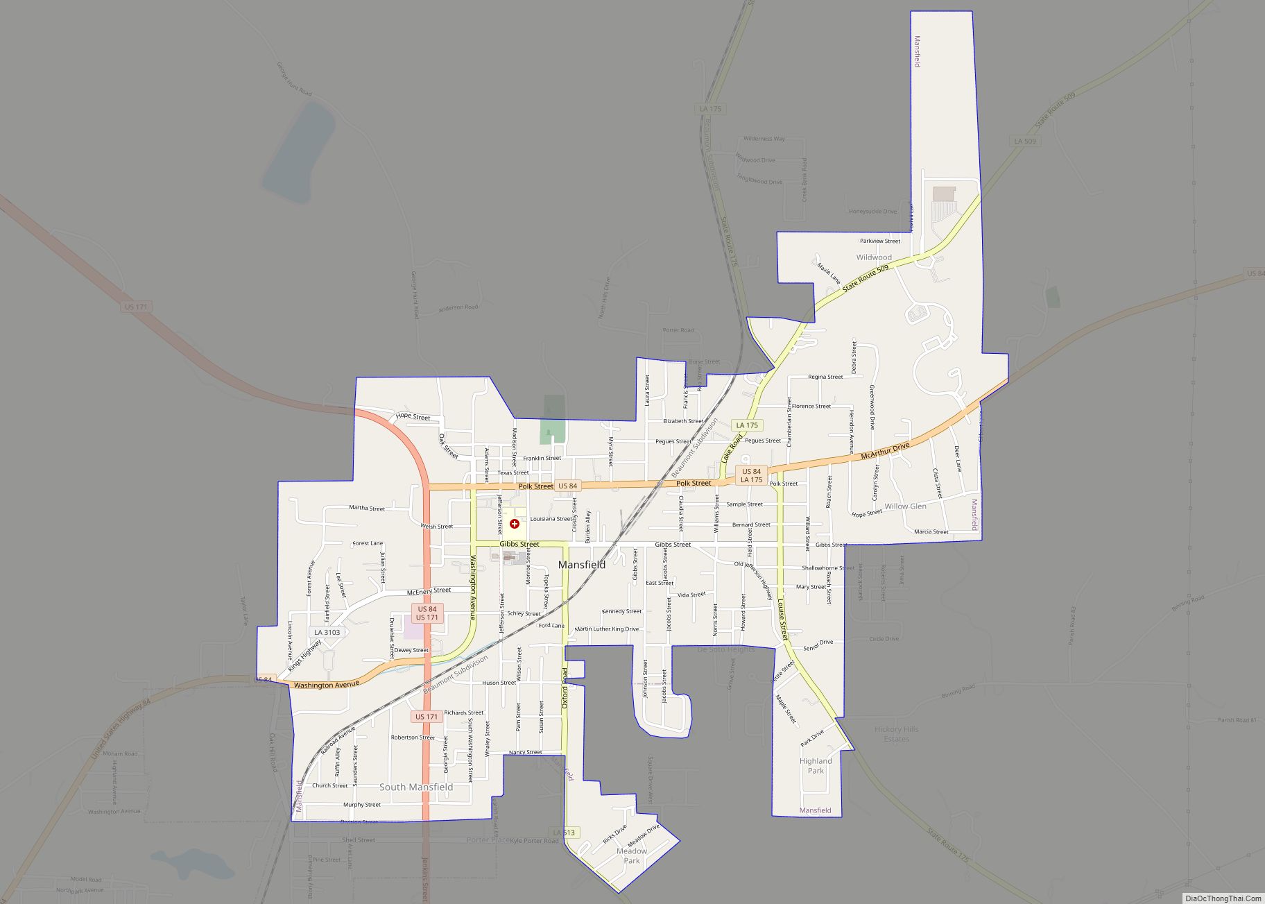
Mansfield is a small city in, and the parish seat of, DeSoto Parish, Louisiana, United States. Mansfield is part of the Shreveport–Bossier City metropolitan statistical area, with a 2020 population of 4,714. Mansfield city overview: Name: Mansfield city LSAD Code: 25 LSAD Description: city (suffix) State: Louisiana County: De Soto Parish Total Area: 3.66 sq mi (9.48 km²) ... Read more
Map of Mansfield city, Louisiana
Map of Marksville city
Marksville is a small city in and the parish seat of Avoyelles Parish, Louisiana, United States. The population was 5,702 at the 2010 census, an increase of 165 over the 2000 tabulation of 5,537. Louisiana’s first land-based casino, Paragon Casino Resort, opened in Marksville in June 1994. It is operated by the federally recognized Tunica-Biloxi ... Read more
Map of Marksville city
Map of Marion town, Louisiana
Marion is a town in Union Parish, Louisiana, United States. The population was 765 at the 2010 census, a decrease from 806 at the 2000 census. This population includes the village of Truxno in the northwestern corner of the city limits. It is part of the Monroe Metropolitan Statistical Area. Marion town overview: Name: Marion ... Read more
Map of Marion town, Louisiana
Map of Maringouin town
Maringouin is a town in Iberville Parish, Louisiana, United States. The population was 1,098 at the 2010 census, down from 1,262 at the 2000 census. At the 2020 population estimates program, its population was 966. It is part of the Baton Rouge metropolitan statistical area. Maringouin town overview: Name: Maringouin town LSAD Code: 43 LSAD ... Read more
Map of Maringouin town
Map of Mathews CDP, Louisiana
Mathews is a census-designated place (CDP) on Bayou Lafourche in Lafourche Parish, Louisiana, United States. The population was 2,273 in 2020. It is part of the Houma–Bayou Cane–Thibodaux metropolitan statistical area. Mathews CDP overview: Name: Mathews CDP LSAD Code: 57 LSAD Description: CDP (suffix) State: Louisiana County: Lafourche Parish Elevation: 10 ft (3 m) Total Area: 3.98 sq mi ... Read more
Map of Mathews CDP, Louisiana
Map of Martin village, Louisiana
Martin is a village in Red River Parish, Louisiana, United States. The population was 594 at the 2010 census. Martin village overview: Name: Martin village LSAD Code: 47 LSAD Description: village (suffix) State: Louisiana County: Red River Parish Elevation: 233 ft (71 m) Total Area: 11.59 sq mi (30.02 km²) Land Area: 11.55 sq mi (29.91 km²) Water Area: 0.04 sq mi (0.10 km²) Total Population: ... Read more
Map of Martin village, Louisiana
Map of Marrero CDP
Marrero is a census-designated place (CDP) in Jefferson Parish, Louisiana, United States. Marrero is on the south side (referred to as the “West Bank”) of the Mississippi River, within the New Orleans–Metairie–Kenner metropolitan statistical area. The population was 32,382 at the 2020 U.S. census. Marrero CDP overview: Name: Marrero CDP LSAD Code: 57 LSAD Description: ... Read more
Map of Marrero CDP
Map of Melville town, Louisiana
Melville is a town in St. Landry Parish, Louisiana, United States. The population was 1,041 at the 2010 census. It is part of the Opelousas−Eunice Micropolitan Statistical Area. It was founded in 1889 and is known as the Atchafalaya River Catfish Capital of Louisiana. Melville town overview: Name: Melville town LSAD Code: 43 LSAD Description: ... Read more
Map of Melville town, Louisiana
Map of McNary village, Louisiana
McNary is a village in Rapides Parish, Louisiana, United States. It is part of the Alexandria, Louisiana, Metropolitan Statistical Area. The population was 211 at the 2000 census. McNary was established as a company lumber town that grew to a population of around 3,000 with a hospital, several stores, a theater, and even a pool. ... Read more
Map of McNary village, Louisiana
Map of Maurice village, Louisiana
Maurice is a town in Vermilion Parish, Louisiana, United States. The population was 964 at the 2010 census and 2,118 for the 2020 Census. It is part of the Abbeville micropolitan statistical area. Maurice village overview: Name: Maurice village LSAD Code: 47 LSAD Description: village (suffix) State: Louisiana County: Vermilion Parish Total Area: 2.78 sq mi (7.21 km²) ... Read more
Map of Maurice village, Louisiana
Map of Mermentau village
Mermentau is a village in Acadia Parish, Louisiana, United States. The population was 661 at the 2010 census. It is part of the Crowley Micropolitan Statistical Area. Mermentau village overview: Name: Mermentau village LSAD Code: 47 LSAD Description: village (suffix) State: Louisiana County: Acadia Parish Elevation: 7 ft (2 m) Total Area: 2.30 sq mi (5.96 km²) Land Area: 2.13 sq mi ... Read more
Map of Mermentau village
Map of Meraux CDP
Meraux is a census-designated place (CDP) in St. Bernard Parish, Louisiana, United States. The population was 6,804 in 2020. It is part of the New Orleans–Metairie–Kenner Metropolitan Statistical Area. Meraux CDP overview: Name: Meraux CDP LSAD Code: 57 LSAD Description: CDP (suffix) State: Louisiana County: St. Bernard Parish Elevation: 7 ft (2 m) Total Area: 4.81 sq mi (12.46 km²) ... Read more
Map of Meraux CDP