Map of White Haven borough, Pennsylvania
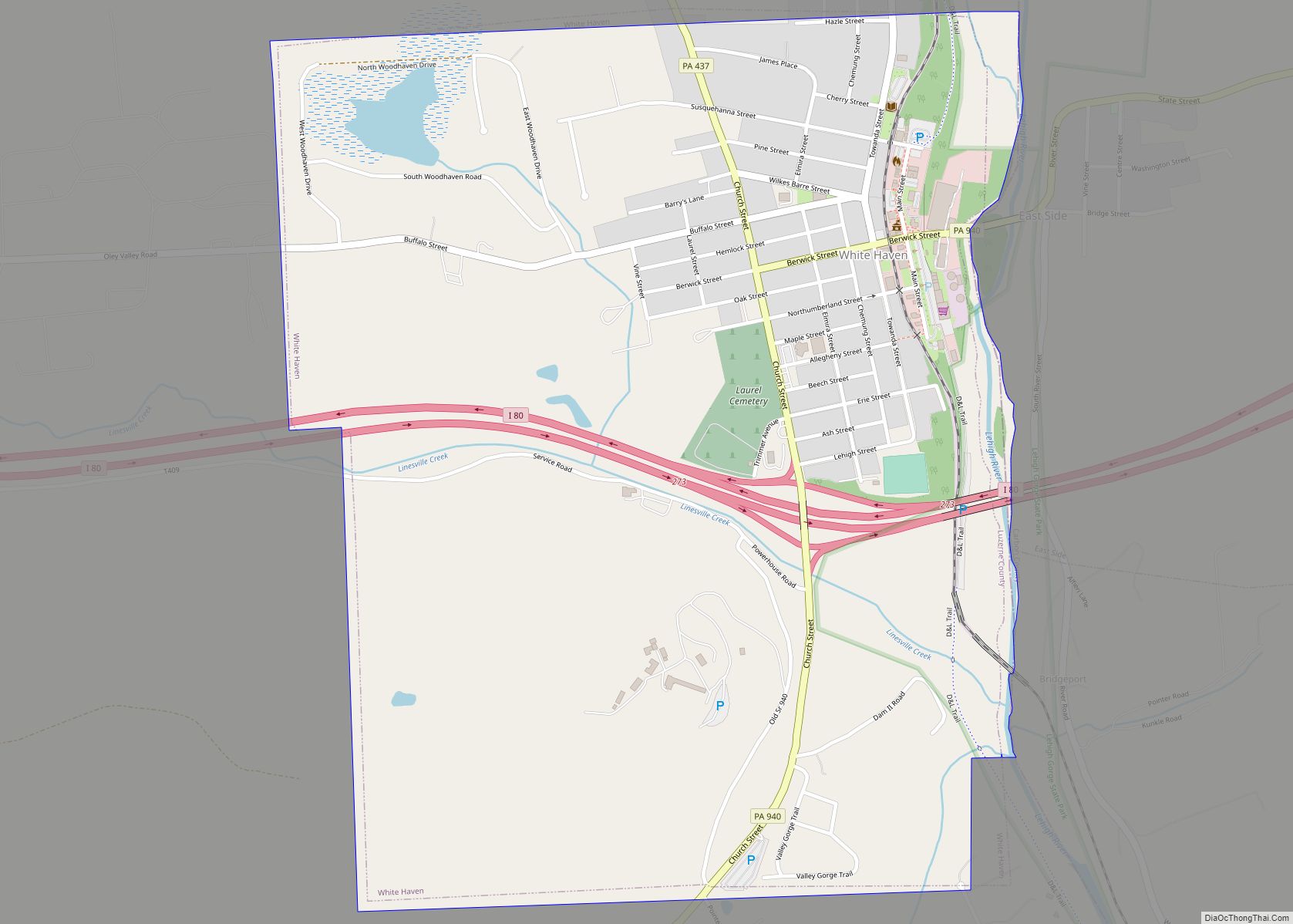
White Haven is a borough in Luzerne County, Pennsylvania, United States. It is located along the Lehigh River. The population was 1,163 at the 2020 census. White Haven borough overview: Name: White Haven borough LSAD Code: 21 LSAD Description: borough (suffix) State: Pennsylvania County: Luzerne County Incorporated: 1842 Elevation: 1,221 ft (372 m) Total Area: 1.23 sq mi (3.19 km²) ... Read more
Map of White Haven borough, Pennsylvania
Map of Whitaker borough
Whitaker is a borough in Allegheny County, Pennsylvania, United States, and is on the Monongahela River 3 miles (5 km) upriver from Pittsburgh. The population was 1,179 at the 2020 census. The borough is named for James Whitaker, a pioneer settler. Whitaker was incorporated January 4, 1904, from part of the former Mifflin Township. Whitaker borough ... Read more
Map of Whitaker borough
Map of Wheatland borough, Pennsylvania
Wheatland is a borough in Mercer County, Pennsylvania, United States, along the Shenango River. The population was 583 at the 2020 census. It is part of the Youngstown-Warren metropolitan area. Wheatland suffered catastrophic damage on May 31, 1985, when an F5 tornado struck the area. In Wheatland, over 100 buildings were leveled, and 18 fatalities ... Read more
Map of Wheatland borough, Pennsylvania
Map of Wilburton Number One CDP
Wilburton Number One is a census-designated place (CDP) in Columbia County, Pennsylvania, United States. It is part of Northeastern Pennsylvania. The population was 196 at the 2010 census. It is part of the Bloomsburg-Berwick micropolitan area. Wilburton Number One CDP overview: Name: Wilburton Number One CDP LSAD Code: 57 LSAD Description: CDP (suffix) State: Pennsylvania ... Read more
Map of Wilburton Number One CDP
Map of Wilmerding borough
Wilmerding is a borough in Allegheny County, Pennsylvania, United States. The population was 1,781 at the 2020 census. It is located 12 miles (19 km) southeast of Pittsburgh. At the start of the twentieth century, it had extensive foundries and machine shops of the Westinghouse Air Brake Company. Wilmerding is adjacent to the borough of Turtle ... Read more
Map of Wilmerding borough
Map of Willow Street CDP
Willow Street is an unincorporated community and census-designated place (CDP) in Lancaster County, Pennsylvania, United States. The population was 7,578 at the 2010 census. In the early part of the 20th century, the main thoroughfare in town was lined with willow trees on both sides for the length of the town, hence the community’s name. ... Read more
Map of Willow Street CDP
Map of Willow Grove CDP
Willow Grove is a census-designated place (CDP) in Montgomery County, Pennsylvania, United States. A community in Philadelphia‘s northern suburbs, the population was 13,730 at the 2020 census. It is located in Upper Dublin Township, Abington Township and Upper Moreland Township. Willow Grove was once known for Willow Grove Park, an amusement park that was open ... Read more
Map of Willow Grove CDP
Map of Williamstown borough, Pennsylvania
Williamstown is a borough in Dauphin County, Pennsylvania, United States. The borough is 38 miles (61 km) northeast of Harrisburg. Formerly, anthracite coal mines and hosiery mills were located in the borough. The population was 1,303 at the 2020 census. Williamstown is part of the Harrisburg–Carlisle Metropolitan Statistical Area. Williamstown borough overview: Name: Williamstown borough LSAD ... Read more
Map of Williamstown borough, Pennsylvania
Map of Williamsport city, Pennsylvania
Williamsport is a city in, and the county seat of, Lycoming County, Pennsylvania, United States. As of the 2020 census, it had a population of 27,754. It is the principal city of the Williamsport Metropolitan Statistical Area, which has a population of about 114,000. Williamsport is the larger principal city of the Williamsport-Lock Haven Combined ... Read more
Map of Williamsport city, Pennsylvania
Map of Williamsburg borough, Pennsylvania
Williamsburg in Morrisons Cove, is a borough in Blair County, Pennsylvania, United States. The population was 1,241 at the 2020 census. It is part of the Altoona, PA Metropolitan Statistical Area. Williamsburg borough overview: Name: Williamsburg borough LSAD Code: 21 LSAD Description: borough (suffix) State: Pennsylvania County: Blair County Incorporated: 1827 Elevation: 846 ft (258 m) Total ... Read more
Map of Williamsburg borough, Pennsylvania
Map of Wilkinsburg borough
Wilkinsburg is a borough in Allegheny County, Pennsylvania, United States. The borough has a population of 14,349 as of the 2020 census. Wilkinsburg is part of the Pittsburgh metropolitan area. The borough was named for John Wilkins Jr., a United States Army officer who served as Quartermaster General of the United States Army from 1796 ... Read more
Map of Wilkinsburg borough
Map of Wilkes-Barre city
Wilkes-Barre (/ˈwɪlksbɛər/ WILKS-bair or /-bɛəri/ -⁠bair-ee) is a city in and the county seat of Luzerne County, Pennsylvania, United States. Located at the center of the Wyoming Valley in Northeastern Pennsylvania, it had a population of 44,328 in the 2020 census. It is the second-largest city, after Scranton, in the Scranton–Wilkes-Barre–Hazleton, PA Metropolitan Statistical Area, ... Read more
Map of Wilkes-Barre city