Map of Dallas town, South Dakota

Map of Dallas town, South Dakota

Dallas is a town in Gregory County, South Dakota, United States. The population was 89 at the 2020 census. Dallas town overview: Name: Dallas town LSAD Code: 43 LSAD Description: town (suffix) State: South Dakota County: Gregory County Incorporated: 1908 Elevation: 2,234 ft (681 m) Total Area: 0.51 sq mi (1.31 km²) Land Area: 0.51 sq mi (1.31 km²) Water Area: 0.00 sq mi (0.00 km²) … Read more

Map of Dakota Dunes CDP

Map of Dakota Dunes CDP

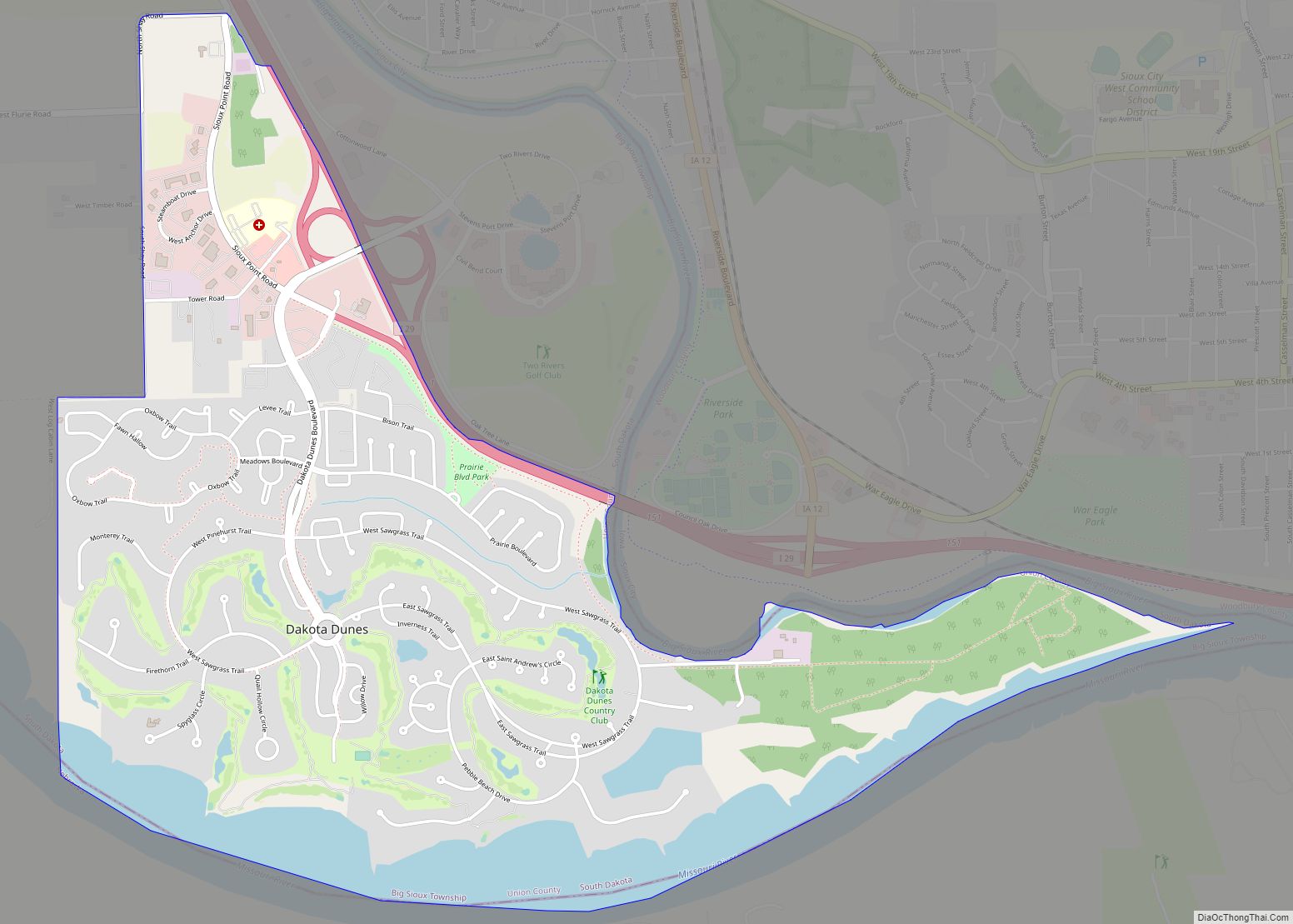
Dakota Dunes is an unincorporated community and census-designated place (CDP), master-planned residential and commercial development covering about 2,000 acres (8.1 km) in Union County in the extreme southeast corner of the U.S. state of South Dakota. The population was 4,020 at the 2020 census. Dakota Dunes CDP overview: Name: Dakota Dunes CDP LSAD Code: 57 LSAD … Read more

Map of Custer city, South Dakota

Map of Custer city, South Dakota

Custer is a city in Custer County, South Dakota, United States. The population was 1,919 at the 2020 census. It is the county seat of Custer County. Custer city overview: Name: Custer city LSAD Code: 25 LSAD Description: city (suffix) State: South Dakota County: Custer County Founded: 1875 Elevation: 5,315 ft (1,620 m) Total Area: 2.54 sq mi (6.58 km²) … Read more

Map of Crooks city

Map of Crooks city

Crooks is a city in Minnehaha County, South Dakota, United States and is a suburb of Sioux Falls. The population was 1,362 at the 2020 census. Crooks was named New Hope until 1904. The town’s present name honors W. A. Crooks, a local politician. Crooks city overview: Name: Crooks city LSAD Code: 25 LSAD Description: … Read more

Map of Delmont city, South Dakota

Map of Delmont city, South Dakota

Delmont is a city in southeastern Douglas County, South Dakota, United States. The population was 153 at the 2020 census. Delmont was laid out in 1886. Delmont city overview: Name: Delmont city LSAD Code: 25 LSAD Description: city (suffix) State: South Dakota County: Douglas County Incorporated: 1913 Elevation: 1,493 ft (455 m) Total Area: 0.76 sq mi (1.98 km²) Land … Read more

Map of Dell Rapids city

Map of Dell Rapids city

Dell Rapids is a city in Minnehaha County, South Dakota, United States. The population was 3,996 at the 2020 census. It is known as “The Little City with the Big Attractions.” The city took its name from the Dells of the Wisconsin River, which were likened to the local rapids on the Big Sioux River. … Read more

Map of Deadwood city

Map of Deadwood city

Deadwood (Lakota: Owáyasuta; “To approve or confirm things”) is a city that serves as county seat of Lawrence County, South Dakota, United States. It was named by early settlers after the dead trees found in its gulch. The city had its heyday from 1876 to 1879, after gold deposits had been discovered there, leading to … Read more

Map of De Smet city, South Dakota

Map of De Smet city, South Dakota

De Smet is a city in and the county seat of Kingsbury County, South Dakota, United States. The population was 1,089 at the 2010 census. De Smet city overview: Name: De Smet city LSAD Code: 25 LSAD Description: city (suffix) State: South Dakota County: Kingsbury County Founded: 1880 Incorporated: 1883 Elevation: 1,726 ft (526 m) Total Area: … Read more

Map of Davis town, South Dakota

Map of Davis town, South Dakota

Davis is a town in Turner County, South Dakota, United States. The population was 54 at the 2020 census. Davis was laid out in 1893, and named for a first settler. Davis town overview: Name: Davis town LSAD Code: 43 LSAD Description: town (suffix) State: South Dakota County: Turner County Incorporated: 1896 Elevation: 1,250 ft (381 m) … Read more

Map of Elk Point city

Map of Elk Point city

Elk Point is a city in and county seat of Union County, South Dakota, United States. The population was 2,149 as of the 2020 census. Elk Point city overview: Name: Elk Point city LSAD Code: 25 LSAD Description: city (suffix) State: South Dakota County: Union County Incorporated: 1873 Elevation: 1,125 ft (343 m) Total Area: 1.55 sq mi (4.01 km²) … Read more

Map of Egan city, South Dakota

Map of Egan city, South Dakota

Egan is a city in Moody County, South Dakota, United States. The population was 241 at the 2020 census. The city has the name of a railroad employee. Egan city overview: Name: Egan city LSAD Code: 25 LSAD Description: city (suffix) State: South Dakota County: Moody County Incorporated: 1881 Elevation: 1,529 ft (466 m) Total Area: 1.07 sq mi … Read more

Map of Edgemont city, South Dakota

Map of Edgemont city, South Dakota

Edgemont is a city in Fall River County, South Dakota, United States. The population was 725 at the 2020 census. The city lies on the far southern edge of the Black Hills in southwestern South Dakota. Edgemont is a crew change point for BNSF freight trains in the Gillette, Wyoming–Alliance, Nebraska division. Edgemont city overview: … Read more