Map of Huntingdon town, Tennessee

Map of Huntingdon town, Tennessee

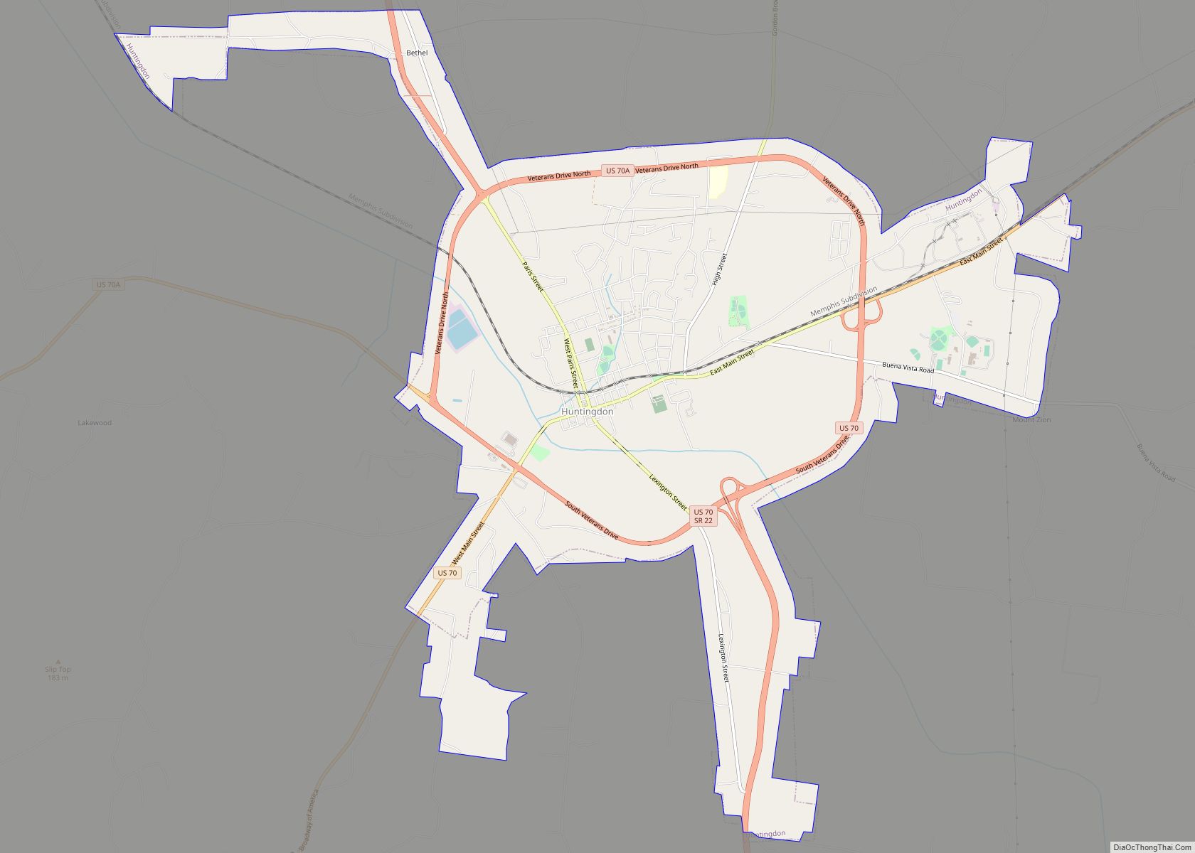
Huntingdon is a town in Carroll County, Tennessee, United States. The population was 4,439 at the 2020 census and 3,985 in 2010. It is the county seat of Carroll County. Huntingdon town overview: Name: Huntingdon town LSAD Code: 43 LSAD Description: town (suffix) State: Tennessee County: Carroll County Elevation: 410 ft (120 m) Total Area: 11.89 sq mi (30.79 km²) … Read more

Map of Hunter CDP, Tennessee

Map of Hunter CDP, Tennessee

Hunter (also called Stoney Creek) is a census-designated place (CDP) and unincorporated community located northeast of Elizabethton in Carter County, Tennessee, United States, along Tennessee State Route 91 and the Watauga River. Its population was 1,854 as of the 2010 census. It is part of the Johnson City Metropolitan Statistical Area, which is a component … Read more

Map of Humboldt city, Tennessee

Map of Humboldt city, Tennessee

Humboldt is a city in Gibson and Madison counties, Tennessee. The population was 8,452 at the 2010 census, a decline of 1,015 from 2000. It is the principal city of and is included in the Humboldt, Tennessee Micropolitan Statistical Area, which is included in the Jackson, Tennessee-Humboldt, Tennessee Combined Statistical Area. Humboldt city overview: Name: … Read more

Map of Hornsby town

Map of Hornsby town

Hornsby is a town in Hardeman County, Tennessee. The population was 303 at the 2010 census. The town is just east of Bolivar along U.S. Highway 64. Hornsby town overview: Name: Hornsby town LSAD Code: 43 LSAD Description: town (suffix) State: Tennessee County: Hardeman County Elevation: 381 ft (116 m) Total Area: 1.05 sq mi (2.72 km²) Land Area: 1.05 sq mi … Read more

Map of Hornbeak town

Map of Hornbeak town

Hornbeak is a town in Obion County, Tennessee, United States. The population was 424 as of the 2010 census. It is part of the Union City, TN–KY Micropolitan Statistical Area. Hornbeak was originally known as Wilsonville, not to be confused with the settlement of the same name in Cocke County. It was renamed Hornbeak after … Read more

Map of Jefferson City, Tennessee

Map of Jefferson City, Tennessee

Jefferson City (originally named Mossy Creek) is a city in Jefferson County, Tennessee, United States. It is part of the Morristown Metropolitan Statistical Area. As of the 2020 census the population was 8,419. Jefferson City overview: Name: Jefferson City LSAD Code: 25 LSAD Description: city (suffix) State: Tennessee County: Jefferson County Incorporated: 1901 Elevation: 1,161 ft … Read more

Map of Jasper town, Tennessee

Map of Jasper town, Tennessee

Jasper is a town in and the county seat of Marion County, Tennessee, United States. The population was 3,612 at the 2020 census. The town was formed in 1820 from lands acquired from Betsy Pack (1770–1851), daughter of Cherokee Chief John Lowery. Jasper is part of the Chattanooga, TN–GA Metropolitan Statistical Area. Jasper town overview: … Read more

Map of Jamestown city, Tennessee

Map of Jamestown city, Tennessee

Jamestown is a city in and the county seat of Fentress County, Tennessee, United States. The population of the city was 1,959 at the 2010 census. Jamestown city overview: Name: Jamestown city LSAD Code: 25 LSAD Description: city (suffix) State: Tennessee County: Fentress County Founded: 1823 Incorporated: 1837 Elevation: 1,716 ft (523 m) Total Area: 3.11 sq mi (8.07 km²) … Read more

Map of Kingston Springs town

Map of Kingston Springs town

Kingston Springs is a town in Cheatham County, Tennessee, United States. The population was 2,824 at the 2020 census and 2,756 at the 2010 census. Kingston Springs town overview: Name: Kingston Springs town LSAD Code: 43 LSAD Description: town (suffix) State: Tennessee County: Cheatham County Elevation: 522 ft (159 m) Total Area: 10.06 sq mi (26.04 km²) Land Area: 10.05 sq mi … Read more

Map of Kingsport city

Map of Kingsport city

Kingsport is a city in Sullivan and Hawkins counties in the U.S. state of Tennessee. As of the 2020 census, its population was 55,442. Lying along the Holston River, Kingsport is commonly included in what is known as the Mountain Empire, which spans a portion of southwest Virginia and the mountainous counties in northeastern Tennessee. … Read more

Map of Kimball town, Tennessee

Map of Kimball town, Tennessee

Kimball is a town in Marion County, Tennessee, United States. The population was 1,545 at the 2020 census and 1,395 in 2010. It is part of the Chattanooga, TN–GA Metropolitan Statistical Area. Kimball town overview: Name: Kimball town LSAD Code: 43 LSAD Description: town (suffix) State: Tennessee County: Marion County Elevation: 676 ft (206 m) Total Area: … Read more

Map of Kenton town, Tennessee

Map of Kenton town, Tennessee

Kenton is a town in Gibson and Obion counties, Tennessee. The population was 1,281 at the 2010 census, a decline of 25 from 2000. The Gibson County portion of Kenton is part of the Humboldt, TN Micropolitan Statistical Area, while the Obion County portion is part of the Union City, TN–KY Micropolitan Statistical Area. Kenton … Read more