Map of Baileyton town, Tennessee

Map of Baileyton town, Tennessee

Baileyton is a town in northern Greene County, Tennessee, United States. The population was 431 at the 2010 census, down from 504 at the 2000 census. Baileyton is located 13 miles (21 km) north of Greeneville and 18 miles (29 km) southeast of Rogersville. Baileyton town overview: Name: Baileyton town LSAD Code: 43 LSAD Description: town (suffix) … Read more

Map of Auburntown town

Map of Auburntown town

Auburntown is a town in Cannon County, Tennessee, United States. The population was 272 as of the 2020 census, up from 269 at the 2010 census. Auburntown town overview: Name: Auburntown town LSAD Code: 43 LSAD Description: town (suffix) State: Tennessee County: Cannon County Incorporated: 1949 Elevation: 715 ft (218 m) Total Area: 0.58 sq mi (1.50 km²) Land Area: … Read more

Map of Atwood town, Tennessee

Map of Atwood town, Tennessee

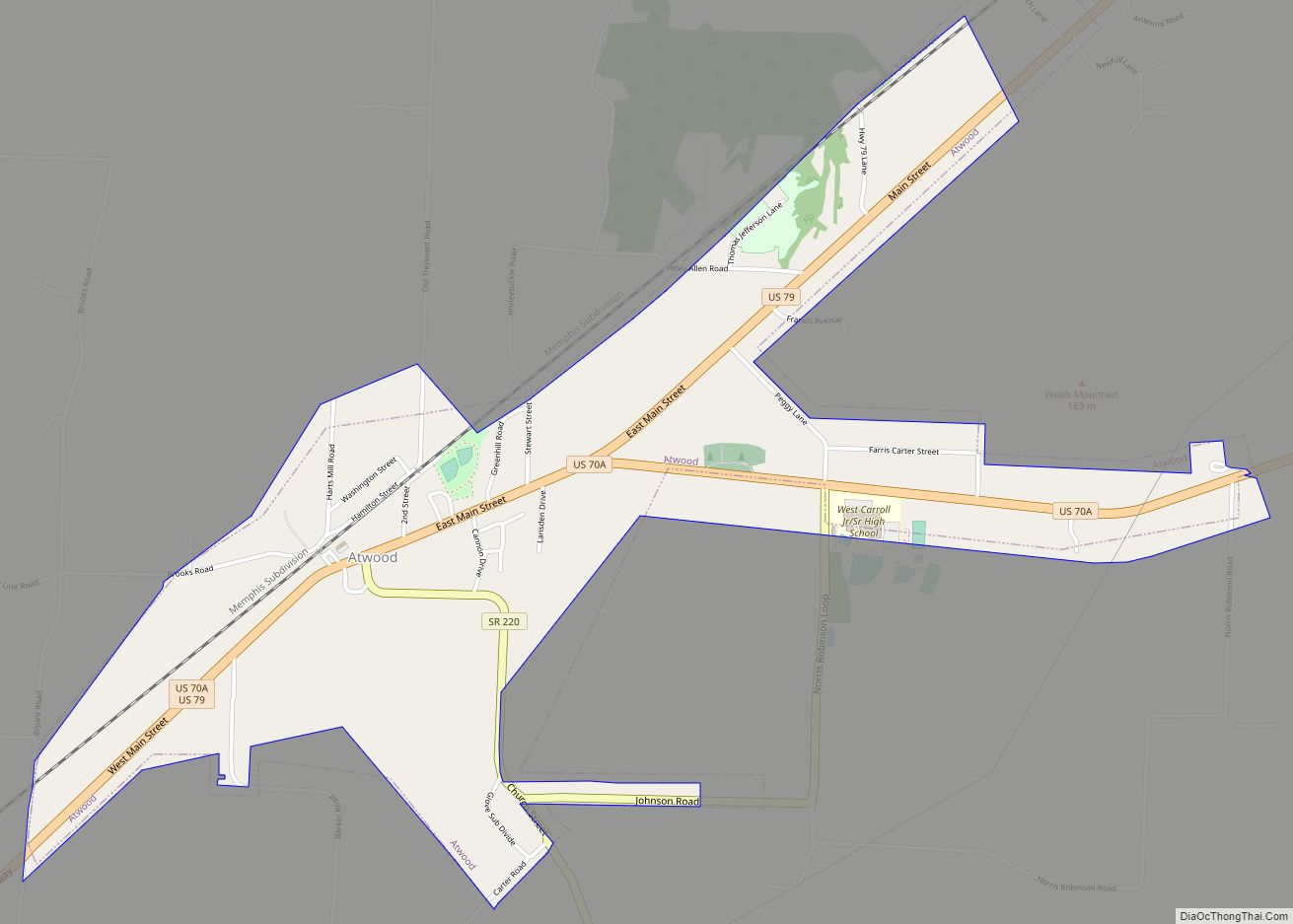
Atwood is a town in Carroll County, Tennessee, United States. The population was 1,008 at the 2020 census. Atwood was incorporated as a town in 1941. Atwood town overview: Name: Atwood town LSAD Code: 43 LSAD Description: town (suffix) State: Tennessee County: Carroll County Incorporated: 1941 Elevation: 443 ft (135 m) Total Area: 1.73 sq mi (4.49 km²) Land Area: … Read more

Map of Atoka town, Tennessee

Map of Atoka town, Tennessee

Atoka (/əˈtoʊkə/) is a local government area with a town charter in Tipton County, Tennessee, United States. In 1888, Atoka was a stop on the Newport News & Mississippi Valley Railroad. Today the City of New Orleans Amtrak passenger train makes its daily route between New Orleans and Chicago, through Atoka. The population was 10,008 … Read more

Map of Bethel Springs town

Map of Bethel Springs town

Bethel Springs is a town in McNairy County, Tennessee. The population was 998 at the 2020 census. Bethel Springs town overview: Name: Bethel Springs town LSAD Code: 43 LSAD Description: town (suffix) State: Tennessee County: McNairy County Elevation: 479 ft (146 m) Total Area: 2.23 sq mi (5.78 km²) Land Area: 2.23 sq mi (5.78 km²) Water Area: 0.00 sq mi (0.00 km²) Total Population: 742 … Read more

Map of Berry Hill city

Map of Berry Hill city

Berry Hill is a city in Davidson County, Tennessee. As of the 2020 census, the population was 2,112, up from o at the 2010 census010 census 2010 census 537. The current mayor is Dennis Sheffield. Berry Hill city overview: Name: Berry Hill city LSAD Code: 25 LSAD Description: city (suffix) State: Tennessee County: Davidson County … Read more

Map of Benton town, Tennessee

Map of Benton town, Tennessee

Benton is a town in Polk County, Tennessee, United States. The population was 1,532 at the 2020 census. It is the county seat of Polk County. Benton is included in the Cleveland Metropolitan Statistical Area. Nancy Ward, a Cherokee known as Nanyehi, was a Beloved Woman, a leader among her people. For many years, she … Read more

Map of Bells city

Map of Bells city, Tennessee

Bells is a city in Crockett County, Tennessee. The population was 2,437 at the 2010 census. Bells city overview: Name: Bells city LSAD Code: 25 LSAD Description: city (suffix) State: Tennessee County: Crockett County Elevation: 325 ft (99 m) Total Area: 2.38 sq mi (6.16 km²) Land Area: 2.37 sq mi (6.14 km²) Water Area: 0.01 sq mi (0.02 km²) Total Population: 2,463 Population Density: 1,038.80/sq mi … Read more

Map of Belle Meade city

Map of Belle Meade city

Belle Meade is a city in Davidson County, Tennessee. Its total land area is 3.1 square miles (8.0 km), and its population was 2,912 at the time of the 2010 census. Belle Meade operates independently as a city, complete with its own regulations, a city hall, and police force, but it is also integrated with the … Read more

Map of Bell Buckle town

Map of Bell Buckle town

Bell Buckle is a town in Bedford County, Tennessee, United States. The population was 500 at the 2010 census. The downtown area is listed on the National Register of Historic Places as the Bell Buckle Historic District. Bell Buckle town overview: Name: Bell Buckle town LSAD Code: 43 LSAD Description: town (suffix) State: Tennessee County: … Read more

Map of Beersheba Springs town

Map of Beersheba Springs town

Beersheba Springs /ˈbɜːrʃəbə/ is a town in Grundy County, Tennessee, United States. The population was 477 at the 2010 census. A resort town in the 19th century, Beersheba Springs was the summer home of author Mary Noailles Murfree. It now serves as a major summer meeting center for the Tennessee United Methodist Church. Beersheba Springs … Read more

Map of Bean Station city

Map of Bean Station city

Bean Station is a town in Grainger and Hawkins counties in the state of Tennessee, United States. As of the 2020 census, the population was 2,967. Established in 1776 as a frontier outpost by William Bean, it is considered one of the earliest permanently settled communities in Tennessee. It would grow throughout the rest of … Read more