Map of Tellico Plains town

Map of Tellico Plains town

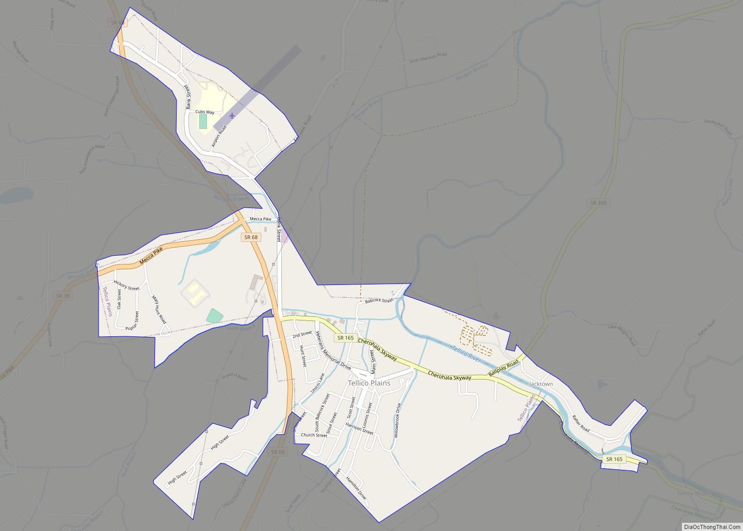
Tellico Plains is a town in Monroe County, Tennessee, United States. The population was 859 at the 2000 census and 880 at the 2010 census. Tellico Plains town overview: Name: Tellico Plains town LSAD Code: 43 LSAD Description: town (suffix) State: Tennessee County: Monroe County Incorporated: 1911 Elevation: 876 ft (267 m) Total Area: 1.95 sq mi (5.06 km²) Land … Read more

Map of Telford CDP, Tennessee

Map of Telford CDP, Tennessee

Telford is a census-designated place and unincorporated community in Washington County, Tennessee, United States, located between Jonesborough and Limestone. As of the 2010 census, it had a population of 921. The community is part of the Johnson City Metropolitan Statistical Area, which is a component of the Johnson City–Kingsport–Bristol, TN-VA Combined Statistical Area – commonly … Read more

Map of Tazewell town

Map of Tazewell town, Tennessee

Tazewell is a town in and the county seat of Claiborne County, Tennessee, United States. The population was 2,165 at the 2000 census and 2,218 at the 2010 census, and 2,348 at the 2020 census. The town is named for Tazewell, Virginia, which itself was named for Henry Tazewell (1753–1799), a U.S. senator from Virginia. … Read more

Map of Hartsville/Trousdale County

Map of Hartsville/Trousdale County, Tennessee

Hartsville/Trousdale County overview: Name: Hartsville/Trousdale County LSAD Code: 00 LSAD Description: 0 State: Tennessee County: Trousdale County FIPS code: 4732742 Online Interactive Map Hartsville/Trousdale County online map. Source: Basemap layers from Google Map, Open Street Map (OSM), Arcgisonline, Wmflabs. Boundary Data from Database of Global Administrative Areas. Hartsville/Trousdale County location map. Where is Hartsville/Trousdale County? … Read more

Map of Trimble town, Tennessee

Map of Trimble town, Tennessee

Trimble is a town in Dyer and Obion counties in the U.S. state of Tennessee. The population was 637 at the 2010 census. The Dyer County portion of Trimble is part of the Dyersburg, TN Micropolitan Statistical Area, while the Obion County portion is part of the Union City, TN–KY Micropolitan Statistical Area. Trimble town … Read more

Map of Trezevant town

Map of Trezevant town

Trezevant is a town in Carroll County, Tennessee. The population was 1,001 at the 2020 census and 959 at the 2010 census. Trezevant town overview: Name: Trezevant town LSAD Code: 43 LSAD Description: town (suffix) State: Tennessee County: Carroll County Founded: 1857 Incorporated: 1911 Elevation: 459 ft (140 m) Total Area: 1.42 sq mi (3.68 km²) Land Area: 1.42 sq mi (3.68 km²) … Read more

Map of Trenton city, Tennessee

Map of Trenton city, Tennessee

Trenton is the county seat and fourth largest city of Gibson County, Tennessee, United States. The population was 4,264 at the 2010 census, down from 4,683 in 2000. Trenton city overview: Name: Trenton city LSAD Code: 25 LSAD Description: city (suffix) State: Tennessee County: Gibson County Incorporated: 1847 Elevation: 331 ft (101 m) Total Area: 8.09 sq mi (20.95 km²) … Read more

Map of Tracy City town

Map of Tracy City town

Tracy City is a town in Grundy County, Tennessee, United States. Incorporated in 1915, the population was 1,481 at the 2010 census. Named after financier Samuel Franklin Tracy, the city developed out of railroad and mining interests after coal was found in 1840. In 2010 the people of Tracy City elected a dead man, Carl … Read more

Map of Union City, Tennessee

Map of Union City, Tennessee

Union City is located in Obion County, Tennessee, United States. 11,170 people were living in the town as of the 2020 census. It is the principal urban settlement of the surrounding micropolitan area, which includes Obion County and Fulton County, Kentucky. Union City is home to Discovery Park of America which is a world-renowned encyclopedic … Read more

Map of Unicoi town

Map of Unicoi town

Unicoi is a town in Unicoi County, Tennessee, United States. The population was 3,519 at the 2000 census and 3,632 at the 2010 census. It is part of the Johnson City Metropolitan Statistical Area, which is a component of the Johnson City–Kingsport–Bristol–Erwin–Flag Pond Combined Statistical Area – commonly known as the “Tri-Cities” region. Unicoi town … Read more

Map of Tusculum city

Map of Tusculum city

Tusculum is a city in Greene County, Tennessee, United States. The population was 3,298 at the 2020 census. It is the site of Tusculum University, the oldest university in Tennessee and the 28th oldest in the United States. Tusculum is a suburb of nearby Greeneville. The population of both Greeneville and Tusculum combined was approximately … Read more

Map of Tullahoma city

Map of Tullahoma city

Tullahoma is a city in Coffee and Franklin counties in southern Middle Tennessee, United States. The population was 20,339 at the 2020 census. In 2019, the population was estimated to be 19,555. It is the principal city of the Tullahoma micropolitan area (a 2009 estimate placed it at 99,927), which consists of Coffee, Franklin, and … Read more