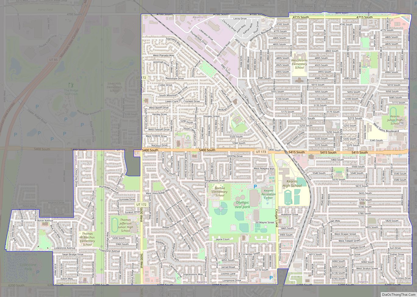
Map of Hatch town, Utah

Map of Hatch town, Utah

Hatch is a town in Garfield County, Utah, United States. The population was 133 at the 2010 census. It is 260 miles (420 km) south of Salt Lake City. Hatch town overview: Name: Hatch town LSAD Code: 43 LSAD Description: town (suffix) State: Utah County: Garfield County Incorporated: January 3, 1934 Elevation: 6,919 ft (2,109 m) Total Area: … Read more

Map of Harrisville city, Utah

Map of Harrisville city, Utah

Harrisville is a city in Weber County, Utah, United States. The population was 5,567 at the 2010 census. It is part of the Ogden–Clearfield, Utah Metropolitan Statistical Area. The current mayor is Michelle Tait. Harrisville city overview: Name: Harrisville city LSAD Code: 25 LSAD Description: city (suffix) State: Utah County: Weber County Elevation: 4,291 ft (1,308 m) … Read more

Map of Hanksville town

Map of Hanksville town

Hanksville is a small town in Wayne County, Utah, United States, at the junction of State Routes 24 and 95. The population was 219 at the 2010 census. Situated in the Colorado Plateau’s cold desert ecological region, the town is just south of the confluence of the Fremont River and Muddy Creek, which together form … Read more

Map of Halls Crossing CDP

Map of Halls Crossing CDP

Halls Crossing is a census-designated place (CDP) on the western edge of San Juan County, Utah, United States. The population was six at the 2010 Census. State Route 276 crosses the Colorado River at Halls Crossing using the Charles Hall Ferry. Halls Crossing CDP overview: Name: Halls Crossing CDP LSAD Code: 57 LSAD Description: CDP … Read more

Map of Halchita CDP

Map of Halchita CDP

Halchita is a census-designated place (CDP) in San Juan County, Utah, United States. The population was 270 at the 2000 census. Halchita CDP overview: Name: Halchita CDP LSAD Code: 57 LSAD Description: CDP (suffix) State: Utah County: San Juan County Elevation: 4,380 ft (1,335 m) Total Area: 17.1 sq mi (44.3 km²) Land Area: 17.1 sq mi (44.3 km²) Water Area: 0.0 sq mi (0.0 km²) … Read more

Map of Gunnison city, Utah

Map of Gunnison city, Utah

Gunnison is a city in the Sevier Valley in southwestern Sanpete County, Utah, United States. The population was 3,509 at the 2020 census. The city was named in honor of John W. Gunnison, a United States Army officer who surveyed for the transcontinental railroad in 1853. Gunnison city overview: Name: Gunnison city LSAD Code: 25 … Read more

Map of Green River city

Map of Green River city, Utah

Green River is a city in Emery County, Utah. The population was 847 at the 2020 census. Green River city overview: Name: Green River city LSAD Code: 25 LSAD Description: city (suffix) State: Utah County: Emery County Incorporated: 1906 Elevation: 4,078 ft (1,243 m) Total Area: 27.26 sq mi (70.61 km²) Land Area: 27.14 sq mi (70.29 km²) Water Area: 0.12 sq mi (0.32 km²) Total … Read more

Map of Grantsville city, Utah

Map of Grantsville city, Utah

Grantsville is the second most populous city in Tooele County, Utah, United States. It is part of the Salt Lake City, Utah Metropolitan Statistical Area. The population was 12,617 at the 2020 census. The city has grown slowly and steadily throughout most of its existence, but rapid increases in growth occurred during the 1970s, 1990s, … Read more

Map of Granite CDP, Utah

Map of Granite CDP, Utah

Granite is a census-designated place (CDP) in Salt Lake County, Utah, United States, adjoining the City of Sandy on the east. As of the 2000 census, the CDP population was 2,018, a decrease from the 1990 population of 3,300 largely due to annexations by Sandy. Salt Lake County has designated a Granite “Community Council” for … Read more

Map of Goshen town, Utah

Map of Goshen town, Utah

Goshen is a town in Utah County, Utah, United States. It is part of the Provo–Orem Metropolitan Statistical Area. The population was 921 at the 2010 census. Goshen town overview: Name: Goshen town LSAD Code: 43 LSAD Description: town (suffix) State: Utah County: Utah County Incorporated: 1910 Elevation: 4,551 ft (1,387 m) Total Area: 0.83 sq mi (2.14 km²) Land … Read more

Map of Helper city

Map of Helper city

Helper is a city in Carbon County, Utah, United States, approximately 110 miles (180 km) southeast of Salt Lake City and 7 miles (11 km) northwest of the city of Price. The population was 2,201 at the 2010 census. The city is located along the Price River and U.S. Route 6/U.S. Route 191, a shortcut between Provo … Read more

Map of Heber city, Utah

Map of Heber city, Utah

Heber city overview: Name: Heber city LSAD Code: 25 LSAD Description: city (suffix) State: Utah County: Wasatch County FIPS code: 4934200 Online Interactive Map Heber online map. Source: Basemap layers from Google Map, Open Street Map (OSM), Arcgisonline, Wmflabs. Boundary Data from Database of Global Administrative Areas. Heber location map. Where is Heber city? Heber … Read more