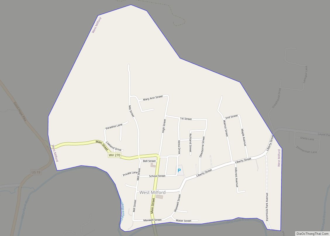
Map of Moorefield town, West Virginia

Map of Moorefield town, West Virginia

Moorefield is a town and the county seat of Hardy County, West Virginia, United States. It is located at the confluence of the South Branch Potomac River and the South Fork South Branch Potomac River. Moorefield was originally chartered in 1777; it was named for Conrad Moore, who owned the land upon which the town … Read more

Map of Montrose town, West Virginia

Map of Montrose town, West Virginia

Montrose is a town in Randolph County, West Virginia, United States. The population was 141 at the 2020 census. The town was so named on account of wild rose bushes near the original town site. Montrose town overview: Name: Montrose town LSAD Code: 43 LSAD Description: town (suffix) State: West Virginia County: Randolph County Elevation: … Read more

Map of Montgomery city, West Virginia

Map of Montgomery city, West Virginia

Montgomery is a city in West Virginia, along the Kanawha River. Most of the city is in Fayette County, with the remainder in Kanawha County. The population was 1,280 at the 2020 census. From 1876 to 1890, the town was called Coal Valley Post Office. The name then changed to Montgomery’s Landing, then to Coal … Read more

Map of Montcalm CDP

Map of Montcalm CDP

Montcalm is a census-designated place (CDP) in Mercer County, West Virginia, United States. The population was 726 at the 2010 census. It is part of the Bluefield, WV-VA micropolitan area which has a population of 107,342. Residents of Montcalm are called Montcalmers. Montcalm CDP overview: Name: Montcalm CDP LSAD Code: 57 LSAD Description: CDP (suffix) … Read more

Map of Monongah town

Map of Monongah town

Monongah is a town in Marion County, West Virginia, United States, situated where Booths Creek flows into the West Fork River. The population was 972 at the 2020 census. Monongah was chartered in 1891, based on Chapter 47 of West Virginia code. Its name is derived from the nearby Monongahela River. Monongah town overview: Name: … Read more

Map of Monaville CDP

Map of Monaville CDP

Monaville is an unincorporated community and census-designated place (CDP) in Logan County, West Virginia, United States. As of the 2010 census, its population was 309. Monaville CDP overview: Name: Monaville CDP LSAD Code: 57 LSAD Description: CDP (suffix) State: West Virginia County: Logan County Elevation: 712 ft (217 m) Total Area: 0.464 sq mi (1.20 km²) Land Area: 0.457 sq mi (1.18 km²) … Read more

Map of Mitchell Heights town

Map of Mitchell Heights town

Mitchell Heights is a town in Logan County, West Virginia, United States. The population was 315 at the 2020 census. The town was named for an early farm on which it was established. Mitchell Heights town overview: Name: Mitchell Heights town LSAD Code: 43 LSAD Description: town (suffix) State: West Virginia County: Logan County Elevation: … Read more

Map of Mineralwells CDP

Map of Mineralwells CDP

Mineralwells, also known as Mineral Wells, is a census-designated place (CDP) in Wood County, West Virginia, United States. It is part of the Parkersburg–Marietta–Vienna, WV-OH Metropolitan Statistical Area. The population was 1,950 at the 2010 census. The United States Census Bureau calls the community Mineralwells, although the United States Postal Service renamed the community’s post … Read more

Map of Pageton CDP

Map of Pageton CDP

Pageton is a census-designated place (CDP) in McDowell County, West Virginia, United States. As of the 2010 census, its population was 187. Pageton is located on the Tug Fork Branch of the Norfolk and Western Railway, along the Pocahontas seam of rich bituminous coal. Pageton is located on State Route 161 between Thorpe and Anawalt. … Read more

Map of New Cumberland city, West Virginia

Map of New Cumberland city, West Virginia

New Cumberland is a city in and the county seat of Hancock County, West Virginia, United States, along the Ohio River. The population was 1,020 as of the 2020 census. It is part of the Weirton–Steubenville metropolitan area. New Cumberland city overview: Name: New Cumberland city LSAD Code: 25 LSAD Description: city (suffix) State: West … Read more

Map of Page CDP, West Virginia

Map of Page CDP, West Virginia

Page is a census-designated place (CDP) and coal town in Fayette County, West Virginia, United States. As of the 2010 census, its population was 224. It was named for William Nelson Page (1854-1932), a civil engineer and industrialist who lived in nearby Ansted, where he managed Gauley Mountain Coal Company and many iron, coal, and … Read more

Map of Nettie CDP

Map of Nettie CDP

Nettie is a census-designated place (CDP) in Nicholas County, West Virginia, United States. Nettie is the location of the southern convergence of state routes 20 and 39. As of the 2020 census, its population was 494. Nettie CDP overview: Name: Nettie CDP LSAD Code: 57 LSAD Description: CDP (suffix) State: West Virginia County: Nicholas County … Read more